
BRUFJELL
General Cargo
Current Trip
| Time Travelled | 15 days |
|---|---|
| Remaining Time | 3 h, 30 mins |
| Distance Travelled | 1846.68 nm |
| Remaining Distance | 30.88 nm |
| AVG Speed | 9.2 Knots |
| MAX Speed | 13.7 Knots |
| AVG Wind | 13.2 knots |
| MAX Wind | 31.9 knots |
| MIN Temp | -10.8°C / 12.56°F |
| MAX Temp | 25.7°C / 78.26°F |
| Draught | 6.2 m |
| Position Received | Now |
Current Position
| Longitude | 3.80183° |
|---|---|
| Latitude | 52.32371° |
| Status | Under way using engine |
| Speed | 7.6 Knots |
| Course | 189.5° |
| Area | North Sea |
| Station | T-AIS |
| Position Received | Now |
Info
Information
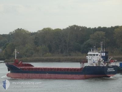
The current position of BRUFJELL is in North Sea with coordinates 52.32371° / 3.80183° as reported on 2024-04-28 04:28 by AIS to our vessel tracker app. The vessel's current speed is 7.6 Knots and is heading at the port of ROTTERDAM. The estimated time of arrival as calculated by MyShipTracking vessel tracking app is 2024-04-28 07:59 LT
The vessel BRUFJELL (IMO: 9346665, MMSI: 257094000) is a General Cargo that was built in 2007 ( 17 years old ). It's sailing under the flag of [NO] Norway.
In this page you can find informations about the vessels current position, last detected port calls, and current voyage information. If the vessels is not in coverage by AIS you will find the latest position.
The current position of BRUFJELL is detected by our AIS receivers and we are not responsible for the reliability of the data. The last position was recorded while the vessel was in Coverage by the Ais receivers of our vessel tracking app.
The current draught of BRUFJELL as reported by AIS is 6.2 meters
Weather
| Temperature | 11.6°C / 52.88°F |
|---|---|
| Wind Speed | 24 knots |
| Direction | 180° S |
| Pressure | 1001 hPa |
| Humidity | 85.5 % |
| Cloud Coverage | 100 % |
Featured Company
Last Port Calls
| Port | Arrival | Departure | Time In Port |
|---|---|---|---|
| 2024-04-11 08:43 | 2024-04-12 13:15 | 1 d | |
| 2024-04-08 09:56 | 2024-04-10 19:20 | 2 d | |
| 2024-03-29 10:01 | 2024-03-31 12:04 | 2 d | |
| 2024-03-26 16:35 | 2024-03-27 13:54 | 21 h | |
| 2024-03-19 01:59 | 2024-03-23 01:07 | 3 d | |
| 2024-03-13 18:04 | 2024-03-15 06:54 | 1 d | |
| 2024-03-11 01:25 | 2024-03-12 15:11 | 1 d | |
| 2024-02-04 09:30 | 2024-02-06 21:34 | 2 d |
Most Visited Ports (Last year)
| Port | Arrivals | |
|---|---|---|
| 4 | ||
| 3 | ||
| 2 | ||
| 2 | ||
| 2 | ||
| 2 |
Last Trips
| Origin | Departure | Destination | Arrival | Distance | |
|---|---|---|---|---|---|
| 2024-04-10 21:20 | 2024-04-11 10:43 | 132.75 nm | |||
| 2024-03-31 14:04 | 2024-04-08 11:56 | 1516.70 nm | |||
| 2024-03-27 14:54 | 2024-03-29 11:01 | 415.03 nm | |||
| 2024-03-23 02:07 | 2024-03-26 17:35 | 906.32 nm | |||
| 2024-03-15 07:54 | 2024-03-19 02:59 | 852.40 nm | |||
| 2024-03-12 16:11 | 2024-03-13 19:04 | 276.32 nm | |||
| 2024-02-06 22:34 | 2024-03-11 02:25 | 2547.76 nm | |||
| 2024-01-26 11:11 | 2024-02-04 10:30 | 1038.51 nm |
Events
| Time | Event | Details | Position / Dest | Info |
|---|---|---|---|---|
| 2024-04-28 03:21 | Status Changed | Under way using engine Default |
52.46703 / 3.84902
NLRTM
|
Speed: 8 kn Course: 190° |
| 2024-04-28 02:52 | Status Changed | Default Under way using engine |
52.53500 / 3.86667
NLRTM
|
Speed: 9 kn Course: 191.7° |
| 2024-04-28 02:40 | Status Changed | Under way using engine Default |
52.56601 / 3.87698
NLRTM
|
Speed: 9.3 kn Course: 189° |
| 2024-04-28 02:40 | IN Coverage |
52.56601 / 3.87698
North Sea
NLRTM
|
Speed: 9.1 kn Course: 188.4° |
|
| 2024-04-27 22:58 | Status Changed | Default Under way using engine |
53.10500 / 4.29833
NLRTM
|
Speed: 10.1 kn Course: 227.7° |
| 2024-04-27 22:54 | OUT of Coverage |
53.11221 / 4.31290
North Sea
NLRTM
|
Speed: 10.1 kn Course: 227.7° |
|
| 2024-04-27 22:26 | Status Changed | Under way using engine Default |
53.16488 / 4.40869
NLRTM
|
Speed: 9 kn Course: 204° |
| 2024-04-27 22:26 | IN Coverage |
53.16367 / 4.40644
North Sea
NLRTM
|
Speed: 9.7 kn Course: 227.4° |
|
| 2024-04-27 20:34 | Status Changed | Default Under way using engine |
53.44500 / 4.57500
NLRTM
|
Speed: 9.2 kn Course: 194.5° |
| 2024-04-27 20:27 | OUT of Coverage |
53.46202 / 4.58296
North Sea
NLRTM
|
Speed: 9.2 kn Course: 194.5° |