
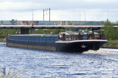
BELLA
Cargo
Current Trip
| Trip Time | 11 days |
|---|---|
| Trip Distance | 222.11 nm |
| AVG Speed | 5 Knots |
| MAX Speed | 5.9 Knots |
| Draught | 0 m |
| AVG Wind | 10.4 knots |
| MAX Wind | 15 knots |
| MIN Temp | 4.5°C / 40.1°F |
| MAX Temp | 11.7°C / 53.06°F |
| Position Received | 11 h, 59 m ago |
Current Position
| Longitude | --- |
|---|---|
| Latitude | --- |
| Status | Under way using engine |
| Speed | |
| Course | --- |
| Area | North Sea |
| Station | T-AIS |
| Position Received | 11 h, 59 m ago |
Info
Information
The current position of BELLA is in North Sea with coordinates 52.27350° / 7.61294° as reported on 2025-12-18 18:06 by AIS to our vessel tracker app. The vessel's current speed is 0 Knots and is currently inside the port of BERGESHOEVEDE.
The vessel BELLA (MMSI: 211517100) is a Cargo It's sailing under the flag of [DE] Germany.
In this page you can find informations about the vessels current position, last detected port calls, and current voyage information. If the vessels is not in coverage by AIS you will find the latest position.
The current position of BELLA is detected by our AIS receivers and we are not responsible for the reliability of the data. The last position was recorded while the vessel was in Coverage by the Ais receivers of our vessel tracking app.
Weather
| Temperature | 9.7°C / 49.46°F |
|---|---|
| Wind Speed | 15 knots |
| Direction | 176° S |
| Pressure | 1012.5 hPa |
| Humidity | 76 % |
| Cloud Coverage | 100 % |
Featured Company
Last Port Calls
| Port | Arrival | Departure | Time In Port |
|---|---|---|---|
| 2025-12-18 08:21 | |||
| 2025-12-06 10:11 | 2025-12-07 05:40 | 19 h | |
| 2025-12-05 10:48 | 2025-12-05 12:32 | 1 h | |
| 2025-12-04 17:51 | 2025-12-05 09:48 | 15 h | |
| 2025-11-29 16:30 | 2025-11-30 06:54 | 14 h | |
| 2025-11-29 13:12 | 2025-11-29 13:34 | 22 m |
Last Trips
| Origin | Departure | Destination | Arrival | Distance | |
|---|---|---|---|---|---|
| 2025-12-07 06:40 | 2025-12-18 09:21 | 222.11 nm | |||
| 2025-12-05 13:32 | 2025-12-06 11:11 | 70.03 nm | |||
| 2025-12-05 10:48 | 2025-12-05 11:48 | 5.46 nm | |||
| 2025-11-30 07:54 | 2025-12-04 18:51 | 61.96 nm | |||
| 2025-11-29 14:34 | 2025-11-29 17:30 | 23.95 nm | |||
| 2025-09-10 09:19 | 2025-11-29 14:12 | 489.84 nm |
Events
| Time | Event | Details | Position / Dest | Info |
|---|---|---|---|---|
| 2025-12-18 18:06 | OUT of Coverage |
52.27350 / 7.61294
North Sea
[DE] BERGESHOEVEDE
|
Speed: Course: 0° |
|
| 2025-12-18 17:48 | IN Coverage |
52.27348 / 7.61295
North Sea
[DE] BERGESHOEVEDE
|
Speed: Course: 0° |
|
| 2025-12-18 08:21 | PORT ARRIVAL |
|
52.27350 / 7.61294
[DE] BERGESHOEVEDE
|
Speed: 4.3 kn Course: 202° |
| 2025-12-18 08:07 | Status Changed | Under way using engine Default |
52.28946 / 7.60802
VEGHEL
|
Speed: 4.3 kn Course: -1° |
| 2025-12-18 08:07 | OUT of Coverage |
52.28946 / 7.60802
North Sea
|
Speed: 4.3 kn Course: 202° |
|
| 2025-12-18 08:06 | Status Changed | Default Under way using engine |
52.29126 / 7.60949
VEGHEL
|
Speed: 4.2 kn Course: 206.1° |
| 2025-12-18 07:38 | IN Coverage |
52.31700 / 7.62577
North Sea
|
Speed: 4 kn Course: 173.4° |
|
| 2025-12-17 07:29 | OUT of Coverage |
52.31896 / 9.07255
North Sea
|
Speed: 4.7 kn Course: 235.5° |
|
| 2025-12-17 07:29 | IN Coverage |
52.31896 / 9.07255
North Sea
|
Speed: 4.7 kn Course: 235.5° |
|
| 2025-12-17 06:29 | OUT of Coverage |
52.37122 / 9.16450
North Sea
|
Speed: 4.8 kn Course: 245.9° |