
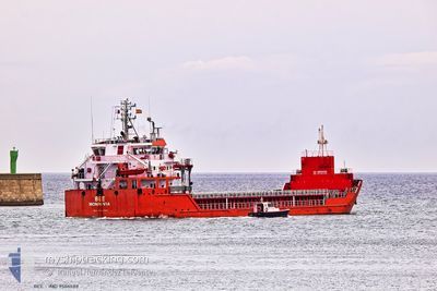
BEE
General Cargo
Current Trip
| Time Travelled | 18 days |
|---|---|
| Remaining Time | --- |
| Distance Travelled | 3074.80 nm |
| Remaining Distance | 375.64 nm |
| AVG Speed | 8.3 Knots |
| MAX Speed | 11.8 Knots |
| AVG Wind | 15.2 knots |
| MAX Wind | 34.5 knots |
| MIN Temp | 5.1°C / 41.18°F |
| MAX Temp | 18°C / 64.4°F |
| Draught | 6.7 m |
| Position Received | 6 d ago |
Current Position
| Longitude | --- |
|---|---|
| Latitude | --- |
| Status | Under way using engine |
| Speed | 11.8 Knots |
| Course | 82.1° |
| Area | Alboran Sea |
| Station | T-AIS |
| Position Received | 6 d ago |
Info
Information
The current position of BEE is in Alboran Sea with coordinates 35.99617° / -5.26281° as reported on 2025-12-16 13:59 by AIS to our vessel tracker app. The vessel's current speed is 11.8 Knots and is heading at the port of NEMRUT. The estimated time of arrival as calculated by MyShipTracking vessel tracking app is 2025-12-24 10:00 LT
The vessel BEE (IMO: 9506588, MMSI: 636016745) is a General Cargo that was built in 2011 ( 14 years old ). It's sailing under the flag of [LR] Liberia.
In this page you can find informations about the vessels current position, last detected port calls, and current voyage information. If the vessels is not in coverage by AIS you will find the latest position.
The current position of BEE is detected by our AIS receivers and we are not responsible for the reliability of the data. The last position was recorded while the vessel was in Coverage by the Ais receivers of our vessel tracking app.
The current draught of BEE as reported by AIS is 6.7 meters
Weather
| Temperature | 16°C / 60.8°F |
|---|---|
| Wind Speed | 15 knots |
| Direction | 64° ENE |
| Pressure | 1016.8 hPa |
| Humidity | 64.8 % |
| Cloud Coverage | 19 % |
Featured Company
Last Port Calls
| Port | Arrival | Departure | Time In Port |
|---|---|---|---|
| 2025-12-03 10:34 | 2025-12-04 19:45 | 1 d | |
| 2025-12-01 04:06 | 2025-12-02 21:03 | 1 d | |
| 2025-11-22 15:35 | 2025-11-28 14:33 | 5 d | |
| 2025-11-04 11:21 | 2025-11-07 14:16 | 3 d | |
| 2025-10-30 06:08 | 2025-11-02 00:20 | 2 d | |
| 2025-10-19 04:18 | 2025-10-23 16:05 | 4 d | |
| 2025-10-11 23:20 | 2025-10-15 15:00 | 3 d | |
| 2025-10-08 10:53 | 2025-10-10 08:23 | 1 d | |
| 2025-10-07 15:54 | 2025-10-08 10:05 | 18 h | |
| 2025-10-03 13:59 | 2025-10-05 06:18 | 1 d |
Last Trips
| Origin | Departure | Destination | Arrival | Distance | |
|---|---|---|---|---|---|
| 2025-12-02 21:03 | 2025-12-03 10:34 | 132.15 nm | |||
| 2025-11-28 14:33 | 2025-12-01 04:06 | 610.55 nm | |||
| 2025-11-07 14:16 | 2025-11-22 15:35 | 2931.59 nm | |||
| 2025-11-02 00:20 | 2025-11-04 11:21 | 532.26 nm | |||
| 2025-10-23 16:05 | 2025-10-30 06:08 | 796.05 nm | |||
| 2025-10-15 15:00 | 2025-10-19 04:18 | 242.13 nm | |||
| 2025-10-10 08:23 | 2025-10-11 23:20 | 270.31 nm | |||
| 2025-10-08 10:05 | 2025-10-08 10:53 | 6.43 nm | |||
| 2025-10-05 06:18 | 2025-10-07 15:54 | 70.30 nm | |||
| 2025-09-16 11:45 | 2025-10-03 13:59 | 3159.07 nm |
Events
| Time | Event | Details | Position / Dest | Info |
|---|---|---|---|---|
| 2025-12-20 09:25 | START Moving |
37.82189 / 9.47083
TR NEM
|
Speed: 3.6 kn Course: 96° |
|
| 2025-12-20 01:55 | STOP Moving |
37.80994 / 9.57286
TR NEM
|
Speed: 0.2 kn Course: 186° |
|
| 2025-12-20 01:53 | START Moving |
37.80981 / 9.57334
TR NEM
|
Speed: 4.3 kn Course: 187° |
|
| 2025-12-20 00:42 | STOP Moving |
37.80167 / 9.59167
TR NEM
|
Speed: Course: -1° |
|
| 2025-12-20 00:24 | START Moving |
37.79833 / 9.59666
TR NEM
|
Speed: 5 kn Course: 299° |
|
| 2025-12-19 23:36 | STOP Moving |
37.79333 / 9.61500
TR NEM
|
Speed: Course: -1° |
|
| 2025-12-19 19:21 | START Moving | 20.45 nm, North West of BIZERTE |
37.45622 / 9.51407
TR NEM
|
Speed: 4.5 kn Course: 5° |
| 2025-12-19 18:50 | STOP Moving | 19.9 nm, North West of BIZERTE |
37.45112 / 9.52368
TR NEM
|
Speed: 0.3 kn Course: 195° |
| 2025-12-16 14:02 | Status Changed | Default Under way using engine |
35.99732 / -5.25085
TR NEM
|
Speed: 11.8 kn Course: 82.1° |
| 2025-12-16 13:59 | OUT of Coverage |
35.99617 / -5.26281
Alboran Sea
TR NEM
|
Speed: 11.8 kn Course: 82.1° |