
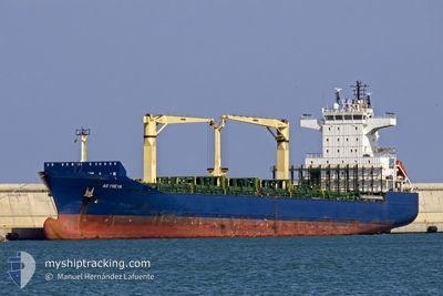
AS FREYA
Container Ship
Current Trip
| Time Travelled | 1 day |
|---|---|
| Remaining Time | 23 h, 23 mins |
| Distance Travelled | 715.19 nm |
| Remaining Distance | 653.45 nm |
| AVG Speed | 14.3 Knots |
| MAX Speed | 17.2 Knots |
| AVG Wind | 12.4 knots |
| MAX Wind | 18 knots |
| MIN Temp | 21.6°C / 70.88°F |
| MAX Temp | 27.3°C / 81.14°F |
| Draught | 8.3 m |
| Position Received | 1 d ago |
Current Position
| Longitude | --- |
|---|---|
| Latitude | --- |
| Status | Under way using engine |
| Speed | 16 Knots |
| Course | 122.6° |
| Area | North Atlantic Ocean |
| Station | T-AIS |
| Position Received | 1 d ago |
Info
Information
The current position of AS FREYA is in North Atlantic Ocean with coordinates 25.48022° / -76.31688° as reported on 2025-12-12 13:42 by AIS to our vessel tracker app. The vessel's current speed is 16 Knots and is heading at the port of PHILIPSBURG. The estimated time of arrival as calculated by MyShipTracking vessel tracking app is 2025-12-14 18:42 LT
The vessel AS FREYA (IMO: 9292436, MMSI: 636092837) is a Container Ship that was built in 2004 ( 21 years old ). It's sailing under the flag of [LR] Liberia.
In this page you can find informations about the vessels current position, last detected port calls, and current voyage information. If the vessels is not in coverage by AIS you will find the latest position.
The current position of AS FREYA is detected by our AIS receivers and we are not responsible for the reliability of the data. The last position was recorded while the vessel was in Coverage by the Ais receivers of our vessel tracking app.
The current draught of AS FREYA as reported by AIS is 8.3 meters
Weather
| Temperature | 27.2°C / 80.96°F |
|---|---|
| Wind Speed | 18 knots |
| Direction | 91° E |
| Pressure | 1017.3 hPa |
| Humidity | 77.8 % |
| Cloud Coverage | --- |
Featured Company
Last Port Calls
| Port | Arrival | Departure | Time In Port |
|---|---|---|---|
| 2025-12-10 07:10 | 2025-12-11 19:20 | 1 d | |
| 2025-12-06 16:56 | 2025-12-07 10:03 | 17 h | |
| 2025-12-03 05:34 | 2025-12-04 20:39 | 1 d | |
| 2025-11-27 08:30 | 2025-11-28 18:48 | 1 d | |
| 2025-11-26 13:04 | |||
| 2025-11-23 18:50 | 2025-11-23 20:33 | 1 h | |
| 2025-11-23 15:11 | 2025-11-23 18:42 | 3 h | |
| 2025-11-23 09:37 | 2025-11-23 15:06 | 5 h | |
| 2025-11-23 06:40 | 2025-11-23 09:30 | 2 h | |
| 2025-11-22 13:13 | 2025-11-22 18:30 | 5 h |
Most Visited Ports (Last year)
| Port | Arrivals | |
|---|---|---|
| 77 | ||
| 20 | ||
| 16 | ||
| 9 | ||
| 9 | ||
| 8 |
Last Trips
| Origin | Departure | Destination | Arrival | Distance | |
|---|---|---|---|---|---|
| 2025-12-07 10:03 | 2025-12-10 07:10 | 956.17 nm | |||
| 2025-12-04 20:39 | 2025-12-06 16:56 | 401.62 nm | |||
| 2025-11-28 18:48 | 2025-12-03 05:34 | 1173.74 nm | |||
| 2025-11-23 20:33 | 2025-11-27 08:30 | 1083.53 nm | |||
| 2025-11-23 20:33 | 2025-11-26 13:04 | 1081.67 nm | |||
| 2025-11-23 18:42 | 2025-11-23 18:50 | 0.13 nm | |||
| 2025-11-23 15:06 | 2025-11-23 15:11 | 0.13 nm | |||
| 2025-11-23 09:30 | 2025-11-23 09:37 | 0.13 nm | |||
| 2025-11-22 18:30 | 2025-11-23 06:40 | 193.40 nm | |||
| 2025-11-22 00:06 | 2025-11-22 13:13 | 197.34 nm |
Events
| Time | Event | Details | Position / Dest | Info |
|---|---|---|---|---|
| 2025-12-12 13:48 | Status Changed | Default Under way using engine |
25.46582 / -76.29162
SXPHI
|
Speed: 16 kn Course: 122.6° |
| 2025-12-12 13:42 | OUT of Coverage |
25.48022 / -76.31688
North Atlantic Ocean
SXPHI
|
Speed: 16 kn Course: 122.6° |
|
| 2025-12-12 10:57 | Change Sea Area | Bahamas part of the North Atlantic Ocean United States part of the North Atlantic Ocean |
25.73587 / -77.09495
North Atlantic Ocean
SXPHI
|
Speed: 16.4 kn Course: 103.2° |
| 2025-12-12 10:57 | Status Changed | Under way using engine Default |
25.73587 / -77.09495
SXPHI
|
Speed: 16 kn Course: 104° |
| 2025-12-12 10:48 | IN Coverage |
25.73587 / -77.09495
North Atlantic Ocean
SXPHI
|
Speed: 16.4 kn Course: 103.2° |
|
| 2025-12-12 01:39 | Status Changed | Default Under way using engine |
26.10167 / -79.80334
SXPHI
|
Speed: 15.3 kn Course: 86.5° |
| 2025-12-12 01:31 | OUT of Coverage |
26.10094 / -79.84531
North Atlantic Ocean
SXPHI
|
Speed: 15.3 kn Course: 86.5° |
|
| 2025-12-12 01:20 | Status Changed | Under way using engine Default |
26.09764 / -79.89387
SXPHI
|
Speed: 15 kn Course: 85° |
| 2025-12-12 01:18 | Status Changed | Default Under way using engine |
26.09667 / -79.90334
SXPHI
|
Speed: 15.5 kn Course: 86.8° |
| 2025-12-12 00:20 | PORT DEPARTURE |
|
26.08720 / -80.11368
SXPHI
|
Speed: 4.9 kn Course: 346° |