
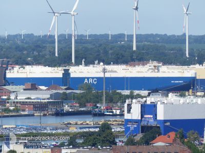
ARC COMMITMENT
Vehicles Carrier
Current Trip
| Time Travelled | 4 days |
|---|---|
| Remaining Time | --- |
| Distance Travelled | 1344.49 nm |
| Remaining Distance | --- |
| AVG Speed | 13.1 Knots |
| MAX Speed | 18.2 Knots |
| AVG Wind | 10.9 knots |
| MAX Wind | 20.8 knots |
| MIN Temp | 5.7°C / 42.26°F |
| MAX Temp | 16.4°C / 61.52°F |
| Draught | 8.3 m |
| Position Received | 3 d ago |
Current Position
| Longitude | --- |
|---|---|
| Latitude | --- |
| Status | Under way using engine |
| Speed | 10 Knots |
| Course | 137.1° |
| Area | North Atlantic Ocean |
| Station | T-AIS |
| Position Received | 3 d ago |
Info
Information
The current position of ARC COMMITMENT is in North Atlantic Ocean with coordinates 36.90663° / -75.92850° as reported on 2026-01-07 05:37 by AIS to our vessel tracker app. The vessel's current speed is 10 Knots and is heading at the port of THESSALONIKI. The estimated time of arrival as calculated by MyShipTracking vessel tracking app is 2026-01-22 09:00 LT
The vessel ARC COMMITMENT (IMO: 9505039, MMSI: 368444000) is a Vehicles Carrier that was built in 2011 ( 15 years old ). It's sailing under the flag of [US] USA.
In this page you can find informations about the vessels current position, last detected port calls, and current voyage information. If the vessels is not in coverage by AIS you will find the latest position.
The current position of ARC COMMITMENT is detected by our AIS receivers and we are not responsible for the reliability of the data. The last position was recorded while the vessel was in Coverage by the Ais receivers of our vessel tracking app.
The current draught of ARC COMMITMENT as reported by AIS is 8.3 meters
Weather
| Temperature | 15.3°C / 59.54°F |
|---|---|
| Wind Speed | 4 knots |
| Direction | 255° WSW |
| Pressure | 1027.5 hPa |
| Humidity | 54.5 % |
| Cloud Coverage | 76 % |
Featured Company
Last Port Calls
Most Visited Ports (Last year)
| Port | Arrivals | |
|---|---|---|
| 5 | ||
| 5 | ||
| 5 | ||
| 3 | ||
| 2 | ||
| 2 |
Last Trips
| Origin | Departure | Destination | Arrival | Distance | |
|---|---|---|---|---|---|
| 2025-12-30 07:39 | 2026-01-04 16:48 | 1931.93 nm | |||
| 2025-11-28 13:43 | 2025-12-26 16:26 | 7098.62 nm | |||
| 2025-11-21 09:36 | 2025-11-28 06:40 | 1018.47 nm | |||
| 2025-11-13 19:08 | 2025-11-13 19:35 | 0.34 nm | |||
| 2025-11-06 07:06 | 2025-11-06 07:48 | 0.57 nm |
Events
| Time | Event | Details | Position / Dest | Info |
|---|---|---|---|---|
| 2026-01-07 05:43 | Status Changed | Default Under way using engine |
36.89471 / -75.91490
GR SKG
|
Speed: 10 kn Course: 137.1° |
| 2026-01-07 05:37 | Status Changed | Under way using engine Default |
36.90663 / -75.92850
GR SKG
|
Speed: 10.1 kn Course: 136° |
| 2026-01-07 05:37 | OUT of Coverage |
36.90663 / -75.92850
North Atlantic Ocean
GR SKG
|
Speed: 10 kn Course: 137.1° |
|
| 2026-01-07 05:18 | Status Changed | Default Under way using engine |
36.94088 / -75.97292
GR SKG
|
Speed: 9.4 kn Course: 125.7° |
| 2026-01-07 03:48 | Status Changed | Under way using engine Default |
37.24965 / -76.13064
GR SKG
|
Speed: 17.3 kn Course: 198° |
| 2026-01-07 03:47 | Status Changed | Default Under way using engine |
37.25471 / -76.12860
GR SKG
|
Speed: 17.3 kn Course: 195.9° |
| 2026-01-07 03:46 | Status Changed | Under way using engine Default |
37.25887 / -76.12698
GR SKG
|
Speed: 17.3 kn Course: 198° |
| 2026-01-07 03:35 | IN Coverage |
37.25887 / -76.12698
North Atlantic Ocean
GR SKG
|
Speed: 17.3 kn Course: 195.9° |
|
| 2026-01-06 23:35 | Status Changed | Default Under way using engine |
38.39635 / -76.35261
GR SKG
|
Speed: 17.9 kn Course: 157.2° |
| 2026-01-06 23:27 | OUT of Coverage |
38.43240 / -76.37304
North Atlantic Ocean
GR SKG
|
Speed: 17.9 kn Course: 157.2° |