
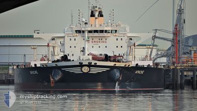
APACHE
Tanker
Current Trip
| Time Travelled | --- |
|---|---|
| Remaining Time | 8 h, 18 mins |
| Distance Travelled | 14209.41 nm |
| Remaining Distance | 100.33 nm |
| AVG Speed | 11.7 Knots |
| MAX Speed | 15.8 Knots |
| AVG Wind | 12.2 knots |
| MAX Wind | 37.8 knots |
| MIN Temp | 1.8°C / 35.24°F |
| MAX Temp | 30°C / 86°F |
| Draught | 15 m |
| Position Received | 2 m ago |
Current Position
| Longitude | -5.17845° |
|---|---|
| Latitude | 54.59949° |
| Status | Under way using engine |
| Speed | 9.2 Knots |
| Course | 344.4° |
| Area | Inner Seas off the West Coast of Scotland |
| Station | T-AIS |
| Position Received | 2 m ago |
Info
Information
The current position of APACHE is in Inner Seas off the West Coast of Scotland with coordinates 54.59949° / -5.17845° as reported on 2024-04-25 08:03 by AIS to our vessel tracker app. The vessel's current speed is 9.2 Knots and is heading at the port of FINNART. The estimated time of arrival as calculated by MyShipTracking vessel tracking app is 2024-04-25 16:23 LT
The vessel APACHE (IMO: 9749489, MMSI: 241458000) is a Tanker It's sailing under the flag of [GR] Greece.
In this page you can find informations about the vessels current position, last detected port calls, and current voyage information. If the vessels is not in coverage by AIS you will find the latest position.
The current position of APACHE is detected by our AIS receivers and we are not responsible for the reliability of the data. The last position was recorded while the vessel was in Coverage by the Ais receivers of our vessel tracking app.
The current draught of APACHE as reported by AIS is 15 meters
Weather
| Temperature | 7.6°C / 45.68°F |
|---|---|
| Wind Speed | 13 knots |
| Direction | 323° NW |
| Pressure | 1005 hPa |
| Humidity | 75.4 % |
| Cloud Coverage | 100 % |
Featured Company
Last Port Calls
| Port | Arrival | Departure | Time In Port |
|---|---|---|---|
| 2024-02-22 22:42 | 2024-02-24 13:02 | 1 d | |
| 2024-02-01 23:55 | 2024-02-03 17:26 | 1 d |
Most Visited Ports (Last year)
| Port | Arrivals | |
|---|---|---|
| 2 | ||
| 2 | ||
| 1 | ||
| 1 | ||
| 1 | ||
| 1 |
Last Trips
| Origin | Departure | Destination | Arrival | Distance | |
|---|---|---|---|---|---|
| 2024-02-03 18:26 | 2024-02-22 16:42 | 5061.39 nm | |||
| 2023-12-25 16:36 | 2024-02-02 00:55 | 7274.75 nm |
Events
| Time | Event | Details | Position / Dest | Info |
|---|---|---|---|---|
| 2024-04-25 07:36 | Change Sea Area | United Kingdom part of the Inner Seas off the West Coast of Scotland United Kingdom part of the Irish Sea and St. George's Channel |
54.52904 / -5.15268
Inner Seas off the West Coast of Scotland
GB FNT
|
Speed: 9.9 kn Course: 348.1° |
| 2024-04-25 07:36 | Status Changed | Under way using engine Default |
54.52904 / -5.15268
GB FNT
|
Speed: 10.1 kn Course: 345° |
| 2024-04-25 07:34 | Status Changed | Default Under way using engine |
54.52493 / -5.15093
GB FNT
|
Speed: 10.3 kn Course: 348.9° |
| 2024-04-25 04:32 | Status Changed | Under way using engine Default |
53.90398 / -5.16814
GB FNT
|
Speed: 12.6 kn Course: 3° |
| 2024-04-25 04:27 | IN Coverage |
53.90398 / -5.16814
Irish Sea and St. George's Channel
GB FNT
|
Speed: 12.6 kn Course: 3.2° |
|
| 2024-04-25 03:14 | Status Changed | Default Under way using engine |
53.64395 / -5.18907
GB FNT
|
Speed: 11.3 kn Course: 3.6° |
| 2024-04-25 03:09 | Status Changed | Under way using engine Default |
53.62742 / -5.19073
GB FNT
|
Speed: 11.3 kn Course: 3° |
| 2024-04-25 03:09 | OUT of Coverage |
53.62742 / -5.19073
Irish Sea and St. George's Channel
GB FNT
|
Speed: 11.3 kn Course: 3.6° |
|
| 2024-04-25 02:19 | Status Changed | Default Under way using engine |
53.47026 / -5.20607
GB FNT
|
Speed: 11 kn Course: 3.2° |
| 2024-04-25 02:14 | Status Changed | Under way using engine Default |
53.45548 / -5.20755
GB FNT
|
Speed: 11 kn Course: 4° |