
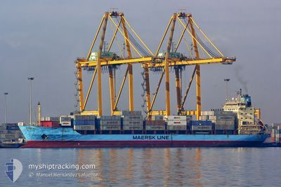
MAERSK ANTWERP
Container Ship
Current Trip
NG APP
| Time Travelled | 1 day |
|---|---|
| Remaining Time | --- |
| Distance Travelled | 194.87 nm |
| Remaining Distance | --- |
| AVG Speed | 12.4 Knots |
| MAX Speed | 17 Knots |
| AVG Wind | 7.4 knots |
| MAX Wind | 13.9 knots |
| MIN Temp | 24.5°C / 76.1°F |
| MAX Temp | 29.7°C / 85.46°F |
| Draught | 9.5 m |
| Position Received | 2022-07-05 18:25 |
Current Position
| Longitude | -17.75759° |
|---|---|
| Latitude | 14.30584° |
| Status | Under way using engine |
| Speed | 12.7 Knots |
| Course | 171.8° |
| Area | North Atlantic Ocean |
| Station | T-AIS |
| Position Received | 2022-07-05 18:25 |
Info
Information
The current position of MAERSK ANTWERP is in North Atlantic Ocean with coordinates 14.30584° / -17.75759° as reported on 2022-07-05 18:25 by AIS to our vessel tracker app. The vessel's current speed is 12.7 Knots
The vessel MAERSK ANTWERP (IMO: 9175781, MMSI: 477958500) is a Container Ship that was built in 1999 ( 25 years old ). It's sailing under the flag of [HK] Hong Kong.
In this page you can find informations about the vessels current position, last detected port calls, and current voyage information. If the vessels is not in coverage by AIS you will find the latest position.
The current position of MAERSK ANTWERP is detected by our AIS receivers and we are not responsible for the reliability of the data. The last position was recorded while the vessel was in Coverage by the Ais receivers of our vessel tracking app.
The current draught of MAERSK ANTWERP as reported by AIS is 9.5 meters
Weather
| Temperature | 29.2°C / 84.56°F |
|---|---|
| Wind Speed | 1 knots |
| Direction | 185° S |
| Pressure | 1011.1 hPa |
| Humidity | 71.9 % |
| Cloud Coverage | 40 % |
Featured Company
Last Port Calls
| Port | Arrival | Departure | Time In Port |
|---|---|---|---|
| 2024-05-07 05:47 | 2024-05-08 17:19 | 1 d | |
| 2024-04-25 15:31 | 2024-04-26 22:59 | 1 d | |
| 2024-04-12 15:11 | 2024-04-13 06:32 | 15 h | |
| 2024-04-08 18:44 | 2024-04-11 16:53 | 2 d | |
| 2024-04-01 10:33 | 2024-04-04 00:01 | 2 d | |
| 2024-03-24 14:48 | 2024-03-26 12:00 | 1 d | |
| 2024-03-20 13:39 | 2024-03-20 18:43 | 5 h | |
| 2024-03-09 08:03 | 2024-03-10 08:02 | 23 h |
Most Visited Ports (Last year)
| Port | Arrivals | |
|---|---|---|
| 17 | ||
| 7 | ||
| 3 | ||
| 2 | ||
| 2 |
Last Trips
| Origin | Departure | Destination | Arrival | Distance | |
|---|---|---|---|---|---|
| 2024-04-26 23:59 | 2024-05-07 06:47 | 464.41 nm | |||
| 2024-04-13 07:32 | 2024-04-25 16:31 | 539.64 nm | |||
| 2024-04-11 17:53 | 2024-04-12 16:11 | 298.50 nm | |||
| 2024-04-04 01:01 | 2024-04-08 19:44 | 652.12 nm | |||
| 2024-03-26 13:00 | 2024-04-01 11:33 | 646.86 nm | |||
| 2024-03-20 19:43 | 2024-03-24 15:48 | 28.84 nm | |||
| 2024-03-10 09:02 | 2024-03-20 14:39 | 752.37 nm | |||
| 2024-02-22 14:26 | 2024-03-09 09:03 | 758.09 nm |
Events
| Time | Event | Details | Position / Dest | Info |
|---|---|---|---|---|
| 2024-05-10 02:54 | START Moving | 5.15 nm, West of SOYO |
-6.09333 / 12.24667
NG APP
|
Speed: 6 kn Course: 61° |
| 2024-05-09 03:33 | STOP Moving | 5.62 nm, West of SOYO |
-6.09500 / 12.23833
NG APP
|
Speed: Course: -1° |
| 2024-05-08 17:19 | PORT DEPARTURE |
|
-4.77131 / 11.83188
NG APP
|
Speed: 4.4 kn Course: 355° |
| 2024-05-08 17:10 | START Moving |
-4.78174 / 11.83073
[CG] POINTE NOIRE
|
Speed: 3.8 kn Course: 54° |
|
| 2024-05-07 06:06 | STOP Moving |
-4.78167 / 11.82667
[CG] POINTE NOIRE
|
Speed: Course: -1° |
|
| 2024-05-07 05:47 | PORT ARRIVAL |
|
-4.77563 / 11.83335
[CG] POINTE NOIRE
|
Speed: 5.2 kn Course: 138° |
| 2024-05-07 04:21 | START Moving | 5.49 nm, North West of POINTE NOIRE |
-4.74167 / 11.75167
NG APP
|
Speed: 4 kn Course: -1° |
| 2024-05-05 09:45 | STOP Moving | 5.53 nm, North West of POINTE NOIRE |
-4.73667 / 11.75333
NG APP
|
Speed: Course: -1° |
| 2024-05-04 13:57 | START Moving | 0.8 nm, South West of BOMA |
-5.86500 / 13.03667
NG APP
|
Speed: 7 kn Course: 211° |
| 2024-05-04 13:34 | STOP Moving | 0.47 nm, South West of BOMA |
-5.86307 / 13.04178
NG APP
|
Speed: 0.1 kn Course: 91° |