
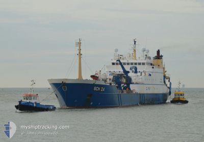
AFRIKA
Factory Trawler
Current Trip
| Time Travelled | 32 days |
|---|---|
| Remaining Time | 6 h, 31 mins |
| Distance Travelled | 952.64 nm |
| Remaining Distance | 97.53 nm |
| AVG Speed | 13.9 Knots |
| MAX Speed | 18.8 Knots |
| AVG Wind | 17.5 knots |
| MAX Wind | 35 knots |
| MIN Temp | 8.1°C / 46.58°F |
| MAX Temp | 19.9°C / 67.82°F |
| Draught | 7.5 m |
| Position Received | 1 m ago |
Current Position
| Longitude | 2.91876° |
|---|---|
| Latitude | 53.57643° |
| Status | Under way using engine |
| Speed | 14.4 Knots |
| Course | 145.9° |
| Area | North Sea |
| Station | T-AIS |
| Position Received | 1 m ago |
Info
Information
The current position of AFRIKA is in North Sea with coordinates 53.57643° / 2.91876° as reported on 2024-05-08 20:04 by AIS to our vessel tracker app. The vessel's current speed is 14.4 Knots and is heading at the port of IJMUIDEN. The estimated time of arrival as calculated by MyShipTracking vessel tracking app is 2024-05-09 02:36 LT
The vessel AFRIKA (IMO: 9175834, MMSI: 245811000) is a Factory Trawler that was built in 1999 ( 25 years old ). It's sailing under the flag of [NL] Netherlands.
In this page you can find informations about the vessels current position, last detected port calls, and current voyage information. If the vessels is not in coverage by AIS you will find the latest position.
The current position of AFRIKA is detected by our AIS receivers and we are not responsible for the reliability of the data. The last position was recorded while the vessel was in Coverage by the Ais receivers of our vessel tracking app.
The current draught of AFRIKA as reported by AIS is 7.5 meters
Weather
| Temperature | 10.8°C / 51.44°F |
|---|---|
| Wind Speed | 5 knots |
| Direction | 157° SSE |
| Pressure | 1029.1 hPa |
| Humidity | 84.2 % |
| Cloud Coverage | 31 % |
Featured Company
Last Port Calls
| Port | Arrival | Departure | Time In Port |
|---|---|---|---|
| 2024-03-27 17:03 | 2024-04-06 10:25 | 9 d | |
| 2024-03-02 22:06 | 2024-03-07 16:33 | 4 d | |
| 2024-03-02 21:06 | 2024-03-02 21:48 | 42 m |
Most Visited Ports (Last year)
| Port | Arrivals | |
|---|---|---|
| 8 | ||
| 2 | ||
| 2 | ||
| 1 |
Events
| Time | Event | Details | Position / Dest | Info |
|---|---|---|---|---|
| 2024-05-08 14:49 | IN Coverage |
54.57089 / 1.66895
North Sea
|
Speed: 14.3 kn Course: 142.2° |
|
| 2024-05-08 03:21 | OUT of Coverage |
56.74614 / -.48370
North Sea
|
Speed: 13.1 kn Course: 148.4° |
|
| 2024-05-08 03:16 | IN Coverage |
56.76087 / -.49993
North Sea
|
Speed: 13.2 kn Course: 148.6° |
|
| 2024-05-08 01:12 | OUT of Coverage |
57.17096 / -.93142
North Sea
|
Speed: 14.3 kn Course: 155.4° |
|
| 2024-05-07 20:45 | IN Coverage |
58.03265 / -2.02917
North Sea
|
Speed: 13.1 kn Course: 140.5° |
|
| 2024-05-07 18:11 | OUT of Coverage |
58.49593 / -2.72907
North Sea
|
Speed: 14.6 kn Course: 141.4° |
|
| 2024-05-07 16:22 | Change Sea Area | United Kingdom part of the North Sea United Kingdom part of the North Atlantic Ocean |
58.71633 / -3.40126
North Sea
|
Speed: 12.8 kn Course: 96.6° |
| 2024-05-07 14:07 | Destination Changed | IJMUIDEN NL FISHING GROUNDS |
58.72973 / -4.35393
IJMUIDEN NL
|
Speed: 12.3 kn Course: 96.4° |
| 2024-05-07 13:46 | IN Coverage |
58.73757 / -4.48799
North Atlantic Ocean
|
Speed: 11.6 kn Course: 97.6° |