
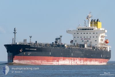
WISCO ADVENTURE
Tanker
Current Trip
| Time Travelled | 6 days |
|---|---|
| Remaining Time | 3 days |
| Distance Travelled | 1052.45 nm |
| Remaining Distance | 920.07 nm |
| AVG Speed | 9.2 Knop |
| MAX Speed | 15.1 Knop |
| AVG Wind | 11 knots |
| MAX Wind | 22.9 knots |
| MIN Temp | 9.1°C / 48.38°F |
| MAX Temp | 28.9°C / 84.02°F |
| Djupgående | 8 m |
| Position mottagen | 1 m sen |
Current Position
| Longitud | -79.76161° |
|---|---|
| Latitude | 24.70315° |
| Status | Under way using engine |
| Fart | 10.8 Knop |
| Kurs | 192.4° |
| Område | North Atlantic Ocean |
| Station | T-AIS |
| Position mottagen | 1 m sen |
Info
Information
The current position of WISCO ADVENTURE is in North Atlantic Ocean with coordinates 24.70315° / -79.76161° as reported on 2024-05-16 04:35 by AIS to our vessel tracker app. The vessel's current speed is 10.8 Knop and is heading at the port of LAKE CHARLES. The estimated time of arrival as calculated by MyShipTracking vessel tracking app is 2024-05-19 22:27 LT
The vessel WISCO ADVENTURE (MMSI: 355037000) is a Tanker It's sailing under the flag of [PA] Panama.
In this page you can find informations about the vessels current position, last detected port calls, and current voyage information. If the vessels is not in coverage by AIS you will find the latest position.
The current position of WISCO ADVENTURE is detected by our AIS receivers and we are not responsible for the reliability of the data. The last position was recorded while the vessel was in Coverage by the Ais receivers of our vessel tracking app.
The current draught of WISCO ADVENTURE as reported by AIS is 8 meters
Weather
| Temperature | 27.8°C / 82.04°F |
|---|---|
| Wind Speed | 12 knots |
| Direction | 170° S |
| Pressure | 1012.8 hPa |
| Humidity | 83.6 % |
| Cloud Coverage | --- |
Featured Company
Last Port Calls
| Port | Arrival | Departure | Time In Port |
|---|---|---|---|
| 2024-05-09 04:33 | 2024-05-09 23:26 | 18 h | |
| 2024-05-07 12:15 | 2024-05-07 21:47 | 9 h | |
| 2024-04-21 17:59 | 2024-04-23 10:09 | 1 d | |
| 2024-04-13 14:45 | 2024-04-15 11:28 | 1 d | |
| 2024-04-11 02:31 | 2024-04-12 08:00 | 1 d | |
| 2024-04-06 11:26 | 2024-04-09 07:06 | 2 d | |
| 2024-03-31 18:56 | 2024-04-02 17:47 | 1 d | |
| 2024-03-19 07:40 | 2024-03-20 19:48 | 1 d | |
| 2024-03-03 15:22 |
Last Trips
| Origin | Departure | Destination | Arrival | Distance | |
|---|---|---|---|---|---|
| 2024-05-07 17:47 | 2024-05-09 00:33 | 45.20 nm | |||
| 2024-04-23 13:09 | 2024-05-07 08:15 | 4129.34 nm | |||
| 2024-04-15 13:28 | 2024-04-21 20:59 | 587.07 nm | |||
| 2024-04-12 10:00 | 2024-04-13 16:45 | 70.73 nm | |||
| 2024-04-09 09:06 | 2024-04-11 04:31 | 544.69 nm | |||
| 2024-04-02 19:47 | 2024-04-06 13:26 | 65.51 nm | |||
| 2024-03-20 20:48 | 2024-03-31 20:56 | 2561.25 nm | |||
| 2024-03-03 16:22 | 2024-03-19 08:40 | 4238.09 nm |
Events
| Tid | Event | Detaljer | Position / Dest | Information |
|---|---|---|---|---|
| 2024-05-16 02:51 | Status ändrad | Under way using engine Default |
24.99987 / -79.65883
US LCH
|
Fart: 10.8 kn Kurs: 178° |
| 2024-05-16 02:51 | I täckningsområde |
24.99987 / -79.65883
North Atlantic Ocean
|
Fart: 11 kn Kurs: 176.9° |
|
| 2024-05-16 02:43 | Djupgående ändrat | 8 8.5 |
25.11529 / -79.66476
US LCH
|
Fart: 10.8 kn Kurs: 178° |
| 2024-05-16 01:05 | Status ändrad | Default Under way using engine |
25.31640 / -79.67423
US LCH
|
Fart: 10.3 kn Kurs: 177° |
| 2024-05-16 00:51 | UTANFÖR täckningsområde |
25.35766 / -79.67666
North Atlantic Ocean
US LCH
|
Fart: 10.3 kn Kurs: 177° |
|
| 2024-05-15 22:34 | Djupgående ändrat | 8.5 8 |
25.73261 / -79.70127
US LCH
|
Fart: 9.3 kn Kurs: 177.1° |
| 2024-05-15 22:34 | ETA ändrat | 2024/05/19 12:00 |
25.73261 / -79.70127
US LCH
|
Fart: 9.3 kn Kurs: 177.1° |
| 2024-05-15 22:30 | Djupgående ändrat | 8 8.5 |
25.74301 / -79.70192
US LCH
|
Fart: 9.3 kn Kurs: 177.2° |
| 2024-05-15 22:04 | Byter havsområde | Bahamas part of the North Atlantic Ocean United States part of the North Atlantic Ocean |
25.80804 / -79.70611
North Atlantic Ocean
US LCH
|
Fart: 9.1 kn Kurs: 176.8° |
| 2024-05-15 16:46 | Djupgående ändrat | 8.5 8 |
26.59775 / -79.66141
US LCH
|
Fart: 9.2 kn Kurs: 184.2° |