
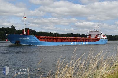
WILSON BREST
General Cargo
Current Trip
| Time Travelled | 4 days |
|---|---|
| Remaining Time | 7 h, 20 mins |
| Distance Travelled | 678.52 nm |
| Remaining Distance | 94.81 nm |
| AVG Speed | 8 Knop |
| MAX Speed | 12.5 Knop |
| AVG Wind | 10.5 knots |
| MAX Wind | 18 knots |
| MIN Temp | 7.9°C / 46.22°F |
| MAX Temp | 16.6°C / 61.88°F |
| Djupgående | 3.4 m |
| Position mottagen | 35 m sen |
Current Position
| Longitud | 17.27803° |
|---|---|
| Latitude | 54.87883° |
| Status | Under way using engine |
| Fart | 10 Knop |
| Kurs | 91.6° |
| Område | Baltic Sea |
| Station | T-AIS |
| Position mottagen | 35 m sen |
Info
Information
The current position of WILSON BREST is in Baltic Sea with coordinates 54.87883° / 17.27803° as reported on 2024-05-15 09:36 by AIS to our vessel tracker app. The vessel's current speed is 10 Knop and is heading at the port of GDANSK. The estimated time of arrival as calculated by MyShipTracking vessel tracking app is 2024-05-15 19:32 LT
The vessel WILSON BREST (IMO: 9126900, MMSI: 314547000) is a General Cargo that was built in 1995 ( 29 År gammal ). It's sailing under the flag of [BB] Barbados.
In this page you can find informations about the vessels current position, last detected port calls, and current voyage information. If the vessels is not in coverage by AIS you will find the latest position.
The current position of WILSON BREST is detected by our AIS receivers and we are not responsible for the reliability of the data. The last position was recorded while the vessel was in Coverage by the Ais receivers of our vessel tracking app.
The current draught of WILSON BREST as reported by AIS is 3.4 meters
Weather
| Temperature | 12.2°C / 53.96°F |
|---|---|
| Wind Speed | 11 knots |
| Direction | 104° ESE |
| Pressure | 1020.3 hPa |
| Humidity | 77.6 % |
| Cloud Coverage | 75 % |
Featured Company
Last Port Calls
| Port | Arrival | Departure | Time In Port |
|---|---|---|---|
| 2024-05-09 03:16 | 2024-05-10 21:28 | 1 d | |
| 2024-05-07 06:22 | 2024-05-07 18:39 | 12 h | |
| 2024-05-04 23:14 | 2024-05-05 02:55 | 3 h | |
| 2024-05-03 22:15 | 2024-05-04 19:17 | 21 h | |
| 2024-04-26 06:40 | 2024-04-27 09:19 | 1 d | |
| 2024-04-23 20:24 | 2024-04-24 22:21 | 1 d | |
| 2024-04-12 23:34 | 2024-04-13 03:40 | 4 h | |
| 2024-04-05 15:32 | 2024-04-08 14:43 | 2 d | |
| 2024-03-28 06:13 | 2024-03-28 18:19 | 12 h | |
| 2024-03-18 10:12 | 2024-03-19 15:51 | 1 d |
Most Visited Ports (Last year)
| Port | Arrivals | |
|---|---|---|
| 2 | ||
| 2 | ||
| 2 | ||
| 2 | ||
| 2 | ||
| 2 |
Last Trips
| Origin | Departure | Destination | Arrival | Distance | |
|---|---|---|---|---|---|
| 2024-05-07 18:39 | 2024-05-09 03:16 | 306.91 nm | |||
| 2024-05-05 02:55 | 2024-05-07 06:22 | 457.38 nm | |||
| 2024-05-04 19:17 | 2024-05-04 23:14 | 36.50 nm | |||
| 2024-04-27 09:19 | 2024-05-03 22:15 | 1047.97 nm | |||
| 2024-04-24 22:21 | 2024-04-26 06:40 | 283.99 nm | |||
| 2024-04-13 03:40 | 2024-04-23 20:24 | 2119.57 nm | |||
| 2024-04-08 14:43 | 2024-04-12 23:34 | 920.04 nm | |||
| 2024-03-28 18:19 | 2024-04-05 15:32 | 667.77 nm | |||
| 2024-03-19 15:51 | 2024-03-28 06:13 | 1874.40 nm | |||
| 2024-03-13 21:14 | 2024-03-18 10:12 | 845.96 nm |
Events
| Tid | Event | Detaljer | Position / Dest | Information |
|---|---|---|---|---|
| 2024-05-15 09:34 | I täckningsområde |
54.87900 / 17.26842
Baltic Sea
PL GDN
|
Fart: 9.9 kn Kurs: 91.7° |
|
| 2024-05-15 08:23 | UTANFÖR täckningsområde |
54.81863 / 16.94731
Baltic Sea
PL GDN
|
Fart: 9.9 kn Kurs: 80.5° |
|
| 2024-05-15 00:32 | Byter havsområde | Polish part of the Baltic Sea German part of the Baltic Sea |
54.50450 / 14.75378
Baltic Sea
PL GDN
|
Fart: 9.8 kn Kurs: 74.2° |
| 2024-05-14 17:14 | Djupgående ändrat | 3.4 5.7 |
54.30369 / 13.11460
PL GDN
|
Fart: 3.8 kn Kurs: 135° |
| 2024-05-14 17:14 | ETA ändrat | 2024/05/15 21:00 2024/05/15 12:00 |
54.30369 / 13.11460
PL GDN
|
Fart: 3.8 kn Kurs: 135° |
| 2024-05-14 17:13 | STARTAR förflyttning | 0.89 nm, East of STRALSUND |
54.30376 / 13.11445
PL GDN
|
Fart: 3.6 kn Kurs: 135° |
| 2024-05-14 17:10 | Status ändrad | Under way using engine Default |
54.30354 / 13.11117
PL GDN
|
Fart: 0.4 kn Kurs: 21° |
| 2024-05-14 16:58 | I täckningsområde |
54.30392 / 13.11147
Baltic Sea
PL GDN
|
Fart: 2.6 kn Kurs: 30.2° |
|
| 2024-05-14 14:13 | Status ändrad | Default Moored |
54.30310 / 13.11023
PL GDN
|
Fart: 0.1 kn Kurs: 18° |
| 2024-05-14 14:07 | UTANFÖR täckningsområde |
54.30315 / 13.11034
Baltic Sea
PL GDN
|
Fart: 0.1 kn Kurs: 169.6° |