
TOTAL ENERGY
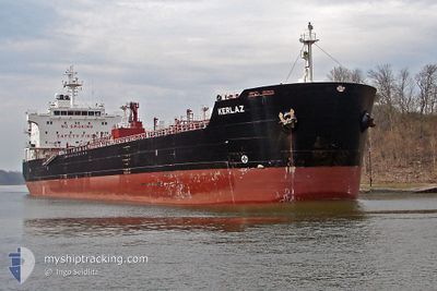
Oil/Chemical Tanker
Current Trip
KARIMUN
| Time Travelled | 3 days |
|---|---|
| Remaining Time | --- |
| Distance Travelled | 108.29 nm |
| Remaining Distance | --- |
| AVG Speed | 8.4 Knop |
| MAX Speed | 13.8 Knop |
| AVG Wind | 6 knots |
| MAX Wind | 10 knots |
| MIN Temp | 28.1°C / 82.58°F |
| MAX Temp | 30.7°C / 87.26°F |
| Djupgående | 7.5 m |
| Position mottagen | 13 h, 52 m sen |
Current Position
| Longitud | 103.28884° |
|---|---|
| Latitude | 1.06122° |
| Status | At anchor |
| Fart | 3.7 Knop |
| Kurs | 39° |
| Område | Malacca Strait |
| Station | T-AIS |
| Position mottagen | 13 h, 52 m sen |
Info
Information
The current position of TOTAL ENERGY is in Malacca Strait with coordinates 1.06122° / 103.28884° as reported on 2024-04-27 14:56 by AIS to our vessel tracker app. The vessel's current speed is 3.7 Knop
The vessel TOTAL ENERGY (IMO: 9302657, MMSI: 525119146) is a Oil/Chemical Tanker that was built in 2004 ( 20 År gammal ). It's sailing under the flag of [ID] Indonesia.
In this page you can find informations about the vessels current position, last detected port calls, and current voyage information. If the vessels is not in coverage by AIS you will find the latest position.
The current position of TOTAL ENERGY is detected by our AIS receivers and we are not responsible for the reliability of the data. The last position was recorded while the vessel was in Coverage by the Ais receivers of our vessel tracking app.
The current draught of TOTAL ENERGY as reported by AIS is 7.5 meters
Weather
| Temperature | 28.9°C / 84.02°F |
|---|---|
| Wind Speed | 6 knots |
| Direction | 159° SSE |
| Pressure | 1009.7 hPa |
| Humidity | 77.3 % |
| Cloud Coverage | 100 % |
Featured Company
Last Port Calls
| Port | Arrival | Departure | Time In Port |
|---|---|---|---|
| 2024-04-23 22:50 | 2024-04-24 22:08 | 23 h | |
| 2024-04-14 06:38 | 2024-04-15 00:15 | 17 h | |
| 2024-03-26 08:11 | 2024-03-30 05:56 | 3 d | |
| 2024-03-08 04:03 | 2024-03-10 05:06 | 2 d | |
| 2024-02-29 17:18 | 2024-03-01 22:11 | 1 d | |
| 2024-02-19 23:25 | 2024-02-21 05:08 | 1 d |
Most Visited Ports (Last year)
| Port | Arrivals | |
|---|---|---|
| 6 | ||
| 5 | ||
| 4 | ||
| 2 | ||
| 1 | ||
| 1 |
Last Trips
| Origin | Departure | Destination | Arrival | Distance | |
|---|---|---|---|---|---|
| 2024-04-15 08:15 | 2024-04-24 06:50 | 51.60 nm | |||
| 2024-03-30 11:26 | 2024-04-14 14:38 | 1641.63 nm | |||
| 2024-03-10 11:06 | 2024-03-26 13:41 | 608.85 nm | |||
| 2024-03-02 06:11 | 2024-03-08 10:03 | 1500.22 nm | |||
| 2024-02-21 13:08 | 2024-03-01 01:18 | 183.71 nm | |||
| 2024-01-31 21:08 | 2024-02-20 07:25 | 3513.31 nm |
Events
| Tid | Event | Detaljer | Position / Dest | Information |
|---|---|---|---|---|
| 2024-04-27 15:35 | STOPPAR förflyttning |
1.07471 / 103.30491
KARIMUN
|
Fart: 0.2 kn Kurs: 1° |
|
| 2024-04-27 15:04 | Status ändrad | Default At anchor |
1.06825 / 103.29551
KARIMUN
|
Fart: 3.7 kn Kurs: 39° |
| 2024-04-27 14:56 | UTANFÖR täckningsområde |
1.06122 / 103.28884
Malacca Strait
KARIMUN
|
Fart: 3.7 kn Kurs: 57.6° |
|
| 2024-04-27 14:53 | Status ändrad | At anchor Default |
1.05996 / 103.28695
KARIMUN
|
Fart: 2.9 kn Kurs: 26° |
| 2024-04-27 14:44 | Status ändrad | Default At anchor |
1.05578 / 103.27854
KARIMUN
|
Fart: 6 kn Kurs: 108.8° |
| 2024-04-27 14:36 | Status ändrad | At anchor Default |
1.05823 / 103.26659
KARIMUN
|
Fart: 6.7 kn Kurs: 117° |
| 2024-04-27 14:32 | Status ändrad | Default At anchor |
1.06043 / 103.26112
KARIMUN
|
Fart: 9 kn Kurs: 136.4° |
| 2024-04-27 14:27 | Status ändrad | At anchor Default |
1.06768 / 103.25241
KARIMUN
|
Fart: 11.5 kn Kurs: 164° |
| 2024-04-27 14:24 | Status ändrad | Default At anchor |
1.07414 / 103.24798
KARIMUN
|
Fart: 12.8 kn Kurs: 178.8° |
| 2024-04-27 14:14 | Byter havsområde | Indonesian part of the Malacca Strait Indonesian part of the Singapore Strait |
1.11063 / 103.24807
Malacca Strait
KARIMUN
|
Fart: 13.1 kn Kurs: 203.9° |