
TIDE NAVIGATOR
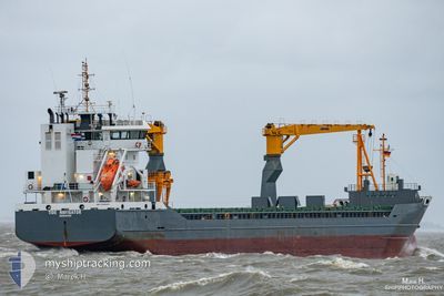
General Cargo
Current Trip
| Time Travelled | 10 days |
|---|---|
| Remaining Time | 1 day |
| Distance Travelled | 2474.81 nm |
| Remaining Distance | 362.12 nm |
| AVG Speed | 10.2 Knop |
| MAX Speed | 13.9 Knop |
| AVG Wind | 17.4 knots |
| MAX Wind | 28 knots |
| MIN Temp | 4.6°C / 40.28°F |
| MAX Temp | 17.4°C / 63.32°F |
| Djupgående | 7 m |
| Position mottagen | 19 m sen |
Current Position
| Longitud | 2.92305° |
|---|---|
| Latitude | 40.38588° |
| Status | Under way using engine |
| Fart | 10.3 Knop |
| Kurs | 48.7° |
| Område | Balearic Sea |
| Station | T-AIS |
| Position mottagen | 19 m sen |
Info
Information
The current position of TIDE NAVIGATOR is in Balearic Sea with coordinates 40.38588° / 2.92305° as reported on 2024-04-28 23:02 by AIS to our vessel tracker app. The vessel's current speed is 10.3 Knop and is heading at the port of GENOVA. The estimated time of arrival as calculated by MyShipTracking vessel tracking app is 2024-04-30 07:48 LT
The vessel TIDE NAVIGATOR (IMO: 9526083, MMSI: 245086000) is a General Cargo that was built in 2011 ( 13 År gammal ). It's sailing under the flag of [NL] Netherlands.
In this page you can find informations about the vessels current position, last detected port calls, and current voyage information. If the vessels is not in coverage by AIS you will find the latest position.
The current position of TIDE NAVIGATOR is detected by our AIS receivers and we are not responsible for the reliability of the data. The last position was recorded while the vessel was in Coverage by the Ais receivers of our vessel tracking app.
The current draught of TIDE NAVIGATOR as reported by AIS is 7 meters
Weather
| Temperature | 15.3°C / 59.54°F |
|---|---|
| Wind Speed | 14 knots |
| Direction | 28° NNE |
| Pressure | 1014.4 hPa |
| Humidity | 83.6 % |
| Cloud Coverage | 75 % |
Featured Company
Last Port Calls
| Port | Arrival | Departure | Time In Port |
|---|---|---|---|
| 2024-04-18 03:15 | 2024-04-18 15:24 | 12 h | |
| 2024-04-16 04:13 | 2024-04-16 11:43 | 7 h | |
| 2024-04-06 07:50 | 2024-04-11 06:46 | 4 d | |
| 2024-03-30 16:38 | 2024-04-03 12:27 | 3 d | |
| 2024-03-25 22:59 | 2024-03-27 23:11 | 2 d | |
| 2024-03-23 18:43 | 2024-03-24 11:07 | 16 h | |
| 2024-03-19 03:43 | 2024-03-19 22:00 | 18 h | |
| 2024-03-12 13:05 | 2024-03-12 13:09 | 4 m | |
| 2024-03-06 06:39 | 2024-03-07 16:04 | 1 d | |
| 2024-03-03 11:36 | 2024-03-05 16:24 | 2 d |
Last Trips
| Origin | Departure | Destination | Arrival | Distance | |
|---|---|---|---|---|---|
| 2024-04-16 13:43 | 2024-04-18 05:15 | 383.97 nm | |||
| 2024-04-11 08:46 | 2024-04-16 06:13 | 522.57 nm | |||
| 2024-04-03 14:27 | 2024-04-06 09:50 | 714.50 nm | |||
| 2024-03-28 00:11 | 2024-03-30 17:38 | 445.28 nm | |||
| 2024-03-24 12:07 | 2024-03-25 23:59 | 312.74 nm | |||
| 2024-03-19 23:00 | 2024-03-23 19:43 | 900.79 nm | |||
| 2024-03-12 14:09 | 2024-03-19 04:43 | 838.49 nm | |||
| 2024-03-07 17:04 | 2024-03-12 14:05 | 1067.69 nm | |||
| 2024-03-05 17:24 | 2024-03-06 07:39 | 133.46 nm | |||
| 2024-02-27 17:33 | 2024-03-03 12:36 | 919.85 nm |
Events
| Tid | Event | Detaljer | Position / Dest | Information |
|---|---|---|---|---|
| 2024-04-28 20:34 | I täckningsområde |
40.08801 / 2.48054
Balearic Sea
IT GOA
|
Fart: 11.3 kn Kurs: 49° |
|
| 2024-04-28 19:18 | UTANFÖR täckningsområde |
39.93250 / 2.25026
Balearic Sea
IT GOA
|
Fart: 11.2 kn Kurs: 49° |
|
| 2024-04-28 18:43 | Upptäckt i hav | Spanish part of the Balearic Sea |
39.86093 / 2.14444
Balearic Sea
IT GOA
|
Fart: 11 kn Kurs: 48.4° |
| 2024-04-28 18:43 | I täckningsområde |
39.86093 / 2.14444
Balearic Sea
IT GOA
|
Fart: 11 kn Kurs: 48.4° |
|
| 2024-04-28 06:44 | Status ändrad | Default Under way using engine |
38.33608 / .14699
IT GOA
|
Fart: 10.8 kn Kurs: 34.1° |
| 2024-04-28 06:37 | Status ändrad | Under way using engine Default |
38.31800 / .13181
IT GOA
|
Fart: 10.8 kn Kurs: 34° |
| 2024-04-28 06:37 | UTANFÖR täckningsområde |
38.31800 / .13181
Mediterranean Sea - Western Basin
IT GOA
|
Fart: 10.8 kn Kurs: 34.1° |
|
| 2024-04-28 06:32 | Status ändrad | Default Under way using engine |
38.30589 / .12152
IT GOA
|
Fart: 10.8 kn Kurs: 34.1° |
| 2024-04-28 06:17 | Status ändrad | Under way using engine Default |
38.26667 / .08841
IT GOA
|
Fart: 10.8 kn Kurs: 33° |
| 2024-04-28 06:12 | Status ändrad | Default Under way using engine |
38.25531 / .07886
IT GOA
|
Fart: 10.9 kn Kurs: 33.6° |