
SO LONG
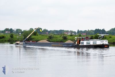
Cargo
Current Trip
Unknown
| Time Travelled | 17 h, 9 mins |
|---|---|
| Remaining Time | --- |
| Distance Travelled | 14.87 nm |
| Remaining Distance | --- |
| AVG Speed | 3.7 Knop |
| MAX Speed | 4.4 Knop |
| AVG Wind | 8.2 knots |
| MAX Wind | 10.6 knots |
| MIN Temp | 18.5°C / 65.3°F |
| MAX Temp | 22.8°C / 73.04°F |
| Djupgående | 0.1 m |
| Position mottagen | 11 h, 44 m sen |
Current Position
| Longitud | 5.70138° |
|---|---|
| Latitude | 51.41616° |
| Status | Constrained by her draught |
| Fart | |
| Kurs | --- |
| Område | North Sea |
| Station | T-AIS |
| Position mottagen | 11 h, 44 m sen |
Info
Information
The current position of SO LONG is in North Sea with coordinates 51.41616° / 5.70138° as reported on 2024-05-13 12:34 by AIS to our vessel tracker app. The vessel's current speed is 0 Knop
The vessel SO LONG (MMSI: 244780194) is a Cargo It's sailing under the flag of [NL] Netherlands.
In this page you can find informations about the vessels current position, last detected port calls, and current voyage information. If the vessels is not in coverage by AIS you will find the latest position.
The current position of SO LONG is detected by our AIS receivers and we are not responsible for the reliability of the data. The last position was recorded while the vessel was in Coverage by the Ais receivers of our vessel tracking app.
The current draught of SO LONG as reported by AIS is 0.1 meters
Weather
| Temperature | 22.9°C / 73.22°F |
|---|---|
| Wind Speed | 11 knots |
| Direction | 182° S |
| Pressure | 1010.3 hPa |
| Humidity | 59.7 % |
| Cloud Coverage | 16 % |
Featured Company
Last Port Calls
| Port | Arrival | Departure | Time In Port |
|---|---|---|---|
| 2024-05-12 18:00 | 2024-05-13 09:10 | 15 h | |
| 2024-05-07 09:37 | 2024-05-07 09:50 | 12 m | |
| 2024-05-07 06:47 | 2024-05-07 07:24 | 37 m | |
| 2024-05-06 05:49 | 2024-05-06 07:48 | 1 h | |
| 2024-05-02 19:30 | 2024-05-03 06:57 | 11 h | |
| 2024-04-30 19:11 | 2024-05-01 13:42 | 18 h | |
| 2024-04-25 20:24 | 2024-04-26 06:20 | 9 h | |
| 2024-04-25 18:07 | 2024-04-25 18:25 | 17 m | |
| 2024-04-24 14:48 | 2024-04-24 15:04 | 15 m | |
| 2024-04-24 11:00 | 2024-04-24 11:36 | 36 m |
Last Trips
| Origin | Departure | Destination | Arrival | Distance | |
|---|---|---|---|---|---|
| 2024-05-07 09:50 | 2024-05-12 18:00 | 71.87 nm | |||
| 2024-05-07 07:24 | 2024-05-07 09:37 | 7.62 nm | |||
| 2024-05-06 07:48 | 2024-05-07 06:47 | 68.71 nm | |||
| 2024-05-03 06:57 | 2024-05-06 05:49 | 60.09 nm | |||
| 2024-05-01 13:42 | 2024-05-02 19:30 | 62.38 nm | |||
| 2024-04-26 06:20 | 2024-04-30 19:11 | 67.26 nm | |||
| 2024-04-25 18:25 | 2024-04-25 20:24 | 8.40 nm | |||
| 2024-04-24 15:04 | 2024-04-25 18:07 | 76.16 nm | |||
| 2024-04-24 11:36 | 2024-04-24 14:48 | 8.05 nm | |||
| 2024-04-18 17:16 | 2024-04-24 11:00 | 161.05 nm |
Events
| Tid | Event | Detaljer | Position / Dest | Information |
|---|---|---|---|---|
| 2024-05-13 12:34 | UTANFÖR täckningsområde |
51.41616 / 5.70138
North Sea
|
Fart: Kurs: 195.6° |
|
| 2024-05-13 12:34 | STOPPAR förflyttning | 3.91 nm, South East of HELMOND |
51.41616 / 5.70138
|
Fart: Kurs: 511° |
| 2024-05-13 11:00 | STARTAR förflyttning | 8.02 nm, South East of HELMOND |
51.35273 / 5.74296
|
Fart: 3.1 kn Kurs: 352.6° |
| 2024-05-13 10:48 | STOPPAR förflyttning | 8.18 nm, South East of HELMOND |
51.35000 / 5.74341
|
Fart: 0.1 kn Kurs: 511° |
| 2024-05-13 10:29 | STARTAR förflyttning | 9.19 nm, South of HELMOND |
51.33251 / 5.74636
|
Fart: 3.1 kn Kurs: 354.4° |
| 2024-05-13 10:18 | STOPPAR förflyttning | 9.33 nm, South of HELMOND |
51.33006 / 5.74677
|
Fart: Kurs: 511° |
| 2024-05-13 07:54 | I täckningsområde |
51.19333 / 5.83671
North Sea
|
Fart: 3.9 kn Kurs: 329.5° |
|
| 2024-05-13 07:10 | AVGÅTT HAMN |
|
51.19125 / 5.83864
|
Fart: Kurs: 511° |
| 2024-05-13 06:07 | UTANFÖR täckningsområde |
51.14270 / 5.83253
North Sea
[BE] KESSENICH
|
Fart: Kurs: 296.5° |
|
| 2024-05-13 06:07 | I täckningsområde |
51.14270 / 5.83253
North Sea
[BE] KESSENICH
|
Fart: Kurs: 296.5° |