
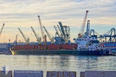
ROOSTER
Cargo
Current Trip
| Time Travelled | 5 days |
|---|---|
| Remaining Time | --- |
| Distance Travelled | 427.86 nm |
| Remaining Distance | --- |
| AVG Speed | 11.4 Knop |
| MAX Speed | 13 Knop |
| AVG Wind | 11.5 knots |
| MAX Wind | 20.8 knots |
| MIN Temp | 28.6°C / 83.48°F |
| MAX Temp | 30.5°C / 86.9°F |
| Djupgående | 6.6 m |
| Position mottagen | 11 m sen |
Current Position
| Longitud | -94.43743° |
|---|---|
| Latitude | 21.18489° |
| Status | Under way using engine |
| Fart | 12.7 Knop |
| Kurs | 19.1° |
| Område | Gulf of Mexico |
| Station | T-AIS |
| Position mottagen | 11 m sen |
Info
Information
The current position of ROOSTER is in Gulf of Mexico with coordinates 21.18489° / -94.43743° as reported on 2024-06-04 23:04 by AIS to our vessel tracker app. The vessel's current speed is 12.7 Knop and is heading at the port of LAKE CHARLES. The estimated time of arrival as calculated by MyShipTracking vessel tracking app is 2024-06-06 15:00 LT
The vessel ROOSTER (IMO: 9723942, MMSI: 538005945) is a Cargo It's sailing under the flag of [MH] Marshall Is.
In this page you can find informations about the vessels current position, last detected port calls, and current voyage information. If the vessels is not in coverage by AIS you will find the latest position.
The current position of ROOSTER is detected by our AIS receivers and we are not responsible for the reliability of the data. The last position was recorded while the vessel was in Coverage by the Ais receivers of our vessel tracking app.
The current draught of ROOSTER as reported by AIS is 6.6 meters
Weather
| Temperature | 29°C / 84.2°F |
|---|---|
| Wind Speed | 16 knots |
| Direction | 125° SE |
| Pressure | 1003.8 hPa |
| Humidity | 85.4 % |
| Cloud Coverage | 4 % |
Featured Company
Most Visited Ports (Last year)
| Port | Arrivals | |
|---|---|---|
| 2 | ||
| 2 | ||
| 2 | ||
| 2 | ||
| 1 | ||
| 1 |
Last Trips
Events
| Tid | Event | Detaljer | Position / Dest | Information |
|---|---|---|---|---|
| 2024-06-04 23:07 | Status ändrad | Default Under way using engine |
21.19500 / -94.43333
USLCH
|
Fart: 12.7 kn Kurs: 19.1° |
| 2024-06-04 23:04 | Status ändrad | Under way using engine Default |
21.18431 / -94.43766
USLCH
|
Fart: 12 kn Kurs: 18° |
| 2024-06-04 22:34 | Status ändrad | Default Under way using engine |
21.08500 / -94.47166
USLCH
|
Fart: 12.5 kn Kurs: 17.8° |
| 2024-06-04 22:21 | Status ändrad | Under way using engine Default |
21.04035 / -94.48859
USLCH
|
Fart: 12.7 kn Kurs: 18° |
| 2024-06-04 22:04 | I täckningsområde |
21.04035 / -94.48859
Gulf of Mexico
USLCH
|
Fart: 12.6 kn Kurs: 18.5° |
|
| 2024-06-04 20:29 | Status ändrad | Default Under way using engine |
20.67255 / -94.62217
USLCH
|
Fart: 12.3 kn Kurs: 17.8° |
| 2024-06-04 20:22 | UTANFÖR täckningsområde |
20.64787 / -94.63116
Gulf of Mexico
USLCH
|
Fart: 12.3 kn Kurs: 17.8° |
|
| 2024-06-04 19:59 | Destination ändrad | USLCH VERA CRUZ |
20.57267 / -94.65728
USLCH
|
Fart: 12.3 kn Kurs: 18.3° |
| 2024-06-04 19:59 | ETA ändrat | 2024/06/06 20:00 2024/05/24 07:00 |
20.57267 / -94.65728
USLCH
|
Fart: 12.3 kn Kurs: 18.3° |
| 2024-06-04 19:58 | Status ändrad | Under way using engine Default |
20.56948 / -94.65842
VERA CRUZ
|
Fart: 12 kn Kurs: 18° |