
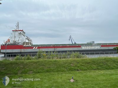
ROERBORG
General Cargo
Current Trip
US DVT
| Time Travelled | 2 days |
|---|---|
| Remaining Time | --- |
| Distance Travelled | 422.04 nm |
| Remaining Distance | --- |
| AVG Speed | 9.9 Knop |
| MAX Speed | 11.6 Knop |
| AVG Wind | 13.3 knots |
| MAX Wind | 27 knots |
| MIN Temp | 10.2°C / 50.36°F |
| MAX Temp | 21.8°C / 71.24°F |
| Djupgående | 8.4 m |
| Position mottagen | 2 d sen |
Current Position
| Longitud | --- |
|---|---|
| Latitude | --- |
| Status | Under way using engine |
| Fart | 11 Knop |
| Kurs | 123.5° |
| Område | Gulf of Mexico |
| Station | T-AIS |
| Position mottagen | 2 d sen |
Info
Information
The current position of ROERBORG is in Gulf of Mexico with coordinates 28.97684° / -94.11097° as reported on 2025-12-08 02:31 by AIS to our vessel tracker app. The vessel's current speed is 11 Knop
The vessel ROERBORG (IMO: 9592599, MMSI: 244820055) is a General Cargo that was built in 2014 ( 11 År gammal ). It's sailing under the flag of [NL] Netherlands.
In this page you can find informations about the vessels current position, last detected port calls, and current voyage information. If the vessels is not in coverage by AIS you will find the latest position.
The current position of ROERBORG is detected by our AIS receivers and we are not responsible for the reliability of the data. The last position was recorded while the vessel was in Coverage by the Ais receivers of our vessel tracking app.
The current draught of ROERBORG as reported by AIS is 8.4 meters
Weather
| Temperature | 8.5°C / 47.3°F |
|---|---|
| Wind Speed | 1 knots |
| Direction | 171° S |
| Pressure | 1017.5 hPa |
| Humidity | 92.6 % |
| Cloud Coverage | --- |
Featured Company
Last Port Calls
| Port | Arrival | Departure | Time In Port |
|---|---|---|---|
| 2025-12-06 10:21 | 2025-12-07 15:04 | 1 d | |
| 2025-11-30 20:16 | 2025-12-04 11:22 | 3 d | |
| 2025-11-19 21:46 | 2025-11-24 16:08 | 4 d | |
| 2025-10-26 09:29 | 2025-10-30 12:49 | 4 d | |
| 2025-10-19 09:24 | 2025-10-24 22:44 | 5 d | |
| 2025-10-07 10:52 | 2025-10-11 16:32 | 4 d |
Last Trips
| Origin | Departure | Destination | Arrival | Distance | |
|---|---|---|---|---|---|
| 2025-12-04 11:22 | 2025-12-06 10:21 | 516.03 nm | |||
| 2025-11-24 16:08 | 2025-11-30 20:16 | 1588.68 nm | |||
| 2025-10-30 12:49 | 2025-11-19 21:46 | 4587.76 nm | |||
| 2025-10-24 22:44 | 2025-10-26 09:29 | 325.29 nm | |||
| 2025-10-11 16:32 | 2025-10-19 09:24 | 1885.92 nm | |||
| 2025-09-23 21:21 | 2025-10-07 10:52 | 2488.54 nm |
Events
| Tid | Event | Detaljer | Position / Dest | Information |
|---|---|---|---|---|
| 2025-12-09 17:41 | STOPPAR förflyttning | 3.71 nm, East of MYRTLE GROVE |
29.60486 / -89.85192
US DVT
|
Fart: 0.1 kn Kurs: 305° |
| 2025-12-08 02:41 | Status ändrad | Default Under way using engine |
28.95949 / -94.08177
US DVT
|
Fart: 11 kn Kurs: 123.5° |
| 2025-12-08 02:31 | UTANFÖR täckningsområde |
28.97684 / -94.11097
Gulf of Mexico
US DVT
|
Fart: 11 kn Kurs: 123.5° |
|
| 2025-12-08 02:01 | Status ändrad | Under way using engine Default |
29.02845 / -94.19826
US DVT
|
Fart: 10.9 kn Kurs: 124° |
| 2025-12-08 01:55 | I täckningsområde |
29.02845 / -94.19826
Gulf of Mexico
US DVT
|
Fart: 11 kn Kurs: 124.5° |
|
| 2025-12-08 01:03 | Status ändrad | Default Under way using engine |
29.11925 / -94.36792
US DVT
|
Fart: 10.8 kn Kurs: 118.5° |
| 2025-12-08 00:56 | UTANFÖR täckningsområde |
29.12932 / -94.38912
Gulf of Mexico
US DVT
|
Fart: 10.8 kn Kurs: 118.5° |
|
| 2025-12-08 00:50 | Status ändrad | Under way using engine Default |
29.13745 / -94.40612
US DVT
|
Fart: 10.8 kn Kurs: 120° |
| 2025-12-08 00:50 | I täckningsområde |
29.13360 / -94.39810
Gulf of Mexico
US DVT
|
Fart: 10.8 kn Kurs: 118° |
|
| 2025-12-07 22:57 | UTANFÖR täckningsområde |
29.34445 / -94.70859
Gulf of Mexico
US DVT
|
Fart: 9.8 kn Kurs: 103.5° |