
OBAN
Passengers Ship
Current Trip
| Trip Time | 2 days |
|---|---|
| Trip Distance | 87.37 nm |
| AVG Speed | 4.9 Knop |
| MAX Speed | 7.2 Knop |
| Djupgående | 2.8 m |
| AVG Wind | 9.1 knots |
| MAX Wind | 14 knots |
| MIN Temp | 11.2°C / 52.16°F |
| MAX Temp | 16.3°C / 61.34°F |
| Position mottagen | 1 m sen |
Current Position
| Longitud | 10.15775° |
|---|---|
| Latitude | 54.33606° |
| Status | Under way sailing |
| Fart | |
| Kurs | --- |
| Område | Baltic Sea |
| Station | T-AIS |
| Position mottagen | 1 m sen |
Info
Information
The current position of OBAN is in Baltic Sea with coordinates 54.33606° / 10.15775° as reported on 2024-05-13 03:25 by AIS to our vessel tracker app. The vessel's current speed is 0 Knop and is currently inside the port of KIEL.
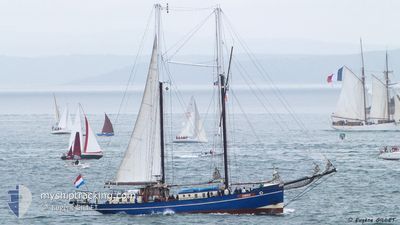
The vessel OBAN (IMO: 9096650, MMSI: 246085000) is a Passengers Ship that was built in 1903 ( 121 År gammal ). It's sailing under the flag of [NL] Netherlands.
In this page you can find informations about the vessels current position, last detected port calls, and current voyage information. If the vessels is not in coverage by AIS you will find the latest position.
The current position of OBAN is detected by our AIS receivers and we are not responsible for the reliability of the data. The last position was recorded while the vessel was in Coverage by the Ais receivers of our vessel tracking app.
The current draught of OBAN as reported by AIS is 2.8 meters
Weather
| Temperature | 8.3°C / 46.94°F |
|---|---|
| Wind Speed | 8 knots |
| Direction | 112° ESE |
| Pressure | 1018.1 hPa |
| Humidity | 78.6 % |
| Cloud Coverage | 9 % |
Featured Company
Last Port Calls
| Port | Arrival | Departure | Time In Port |
|---|---|---|---|
| 2024-05-12 11:44 | |||
| 2024-05-09 15:34 | 2024-05-10 07:42 | 16 h | |
| 2024-05-04 11:33 | 2024-05-09 07:56 | 4 d | |
| 2024-05-03 14:10 | 2024-05-04 06:02 | 15 h | |
| 2024-05-01 12:50 | 2024-05-02 08:04 | 19 h | |
| 2024-04-30 13:30 | 2024-05-01 07:35 | 18 h | |
| 2024-04-27 15:39 | 2024-04-28 08:08 | 16 h | |
| 2024-04-25 12:02 | 2024-04-27 08:59 | 1 d | |
| 2024-04-24 16:52 | 2024-04-25 07:27 | 14 h | |
| 2024-04-24 12:18 | 2024-04-24 12:25 | 6 m |
Last Trips
| Origin | Departure | Destination | Arrival | Distance | |
|---|---|---|---|---|---|
| 2024-05-10 09:42 | 2024-05-12 13:44 | 87.37 nm | |||
| 2024-05-09 09:56 | 2024-05-09 17:34 | 25.34 nm | |||
| 2024-05-04 08:02 | 2024-05-04 13:33 | 18.76 nm | |||
| 2024-05-02 10:04 | 2024-05-03 16:10 | 72.93 nm | |||
| 2024-05-01 09:35 | 2024-05-01 14:50 | 33.24 nm | |||
| 2024-04-28 10:08 | 2024-04-30 15:30 | 98.72 nm | |||
| 2024-04-27 10:59 | 2024-04-27 17:39 | 45.31 nm | |||
| 2024-04-25 09:27 | 2024-04-25 14:02 | 17.62 nm | |||
| 2024-04-24 14:25 | 2024-04-24 18:52 | 29.30 nm | |||
| 2024-04-22 09:09 | 2024-04-24 14:18 | 247.38 nm |
Events
| Tid | Event | Detaljer | Position / Dest | Information |
|---|---|---|---|---|
| 2024-05-12 12:11 | STOPPAR förflyttning |
54.33519 / 10.16069
[DE] KIEL
|
Fart: 0.3 kn Kurs: 511° |
|
| 2024-05-12 11:44 | ANLÄNDER HAMN |
|
54.36248 / 10.17169
[DE] KIEL
|
Fart: 4.1 kn Kurs: 202° |
| 2024-05-12 08:32 | Byter havsområde | German part of the Baltic Sea Danish part of the Baltic Sea |
54.60142 / 10.43476
Baltic Sea
|
Fart: 6.5 kn Kurs: 225.3° |
| 2024-05-12 06:29 | Byter havsområde | Danish part of the Baltic Sea Danish part of the Kattegat |
54.74322 / 10.64657
Baltic Sea
|
Fart: 4.3 kn Kurs: 215° |
| 2024-05-12 06:05 | STARTAR förflyttning | 7.98 nm, South East of MARSTAL |
54.75449 / 10.66895
WINDDEPING
|
Fart: 4.4 kn Kurs: 325.8° |
| 2024-05-11 14:15 | STOPPAR förflyttning | 8.12 nm, South East of MARSTAL |
54.75265 / 10.67152
WINDDEPING
|
Fart: 0.3 kn Kurs: 511° |
| 2024-05-11 11:54 | Status ändrad | Under way sailing Under way using engine |
54.83095 / 10.56639
WINDDEPING
|
Fart: 1.1 kn Kurs: 511° |
| 2024-05-11 07:53 | Status ändrad | Under way using engine Under way sailing |
55.05036 / 10.20130
WINDDEPING
|
Fart: 5.4 kn Kurs: 143.8° |
| 2024-05-11 07:38 | STARTAR förflyttning | 3.44 nm, South West of FAABORG |
55.05417 / 10.16258
WINDDEPING
|
Fart: 5.2 kn Kurs: 56.9° |
| 2024-05-10 13:32 | STOPPAR förflyttning | 3.59 nm, South West of FAABORG |
55.05245 / 10.15938
WINDDEPING
|
Fart: 0.2 kn Kurs: 511° |