
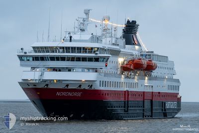
NORDNORGE
Ro-Ro/Passenger Ship
Current Trip
| Time Travelled | 59 mins |
|---|---|
| Remaining Time | 7 h, 23 mins |
| Distance Travelled | 8.50 nm |
| Remaining Distance | 102.20 nm |
| AVG Speed | 13.4 Knop |
| MAX Speed | 14 Knop |
| AVG Wind | 5 knots |
| MAX Wind | 8 knots |
| MIN Temp | -9.5°C / 14.9°F |
| MAX Temp | -2.4°C / 27.68°F |
| Djupgående | 5 m |
| Position mottagen | 2 m sen |
Current Position
| Longitud | --- |
|---|---|
| Latitude | --- |
| Status | Under way using engine |
| Fart | 12.6 Knop |
| Kurs | 228.2° |
| Område | Norwegian Sea |
| Station | T-AIS |
| Position mottagen | 2 m sen |
Info
Information
The current position of NORDNORGE is in Norwegian Sea with coordinates 61.80145° / 5.11912° as reported on 2026-01-04 06:00 by AIS to our vessel tracker app. The vessel's current speed is 12.6 Knop and is heading at the port of BERGEN. The estimated time of arrival as calculated by MyShipTracking vessel tracking app is 2026-01-04 14:26 LT
The vessel NORDNORGE (IMO: 9107784, MMSI: 259371000) is a Ro-Ro/Passenger Ship that was built in 1997 ( 29 År gammal ). It's sailing under the flag of [NO] Norway.
In this page you can find informations about the vessels current position, last detected port calls, and current voyage information. If the vessels is not in coverage by AIS you will find the latest position.
The current position of NORDNORGE is detected by our AIS receivers and we are not responsible for the reliability of the data. The last position was recorded while the vessel was in Coverage by the Ais receivers of our vessel tracking app.
The current draught of NORDNORGE as reported by AIS is 5 meters
Weather
| Temperature | -2.9°C / 26.78°F |
|---|---|
| Wind Speed | 3 knots |
| Direction | 22° NNE |
| Pressure | 1000.9 hPa |
| Humidity | 43.6 % |
| Cloud Coverage | 52 % |
Featured Company
Last Port Calls
| Port | Arrival | Departure | Time In Port |
|---|---|---|---|
| 2026-01-04 05:46 | 2026-01-04 06:04 | 18 m | |
| 2026-01-04 00:33 | 2026-01-04 01:27 | 53 m | |
| 2026-01-03 21:35 | 2026-01-03 22:00 | 25 m | |
| 2026-01-03 16:16 | 2026-01-03 17:42 | 1 h | |
| 2026-01-03 06:29 | 2026-01-03 09:36 | 3 h | |
| 2026-01-02 21:06 | 2026-01-02 21:31 | 25 m | |
| 2026-01-02 15:06 | 2026-01-02 17:37 | 2 h | |
| 2026-01-02 11:58 | 2026-01-02 12:21 | 23 m | |
| 2026-01-02 10:40 | 2026-01-02 10:56 | 16 m | |
| 2026-01-02 06:30 | 2026-01-02 06:52 | 21 m |
Last Trips
| Origin | Departure | Destination | Arrival | Distance | |
|---|---|---|---|---|---|
| 2026-01-04 01:27 | 2026-01-04 05:46 | 52.75 nm | |||
| 2026-01-03 22:00 | 2026-01-04 00:33 | 34.23 nm | |||
| 2026-01-03 17:42 | 2026-01-03 21:35 | 49.33 nm | |||
| 2026-01-03 09:36 | 2026-01-03 16:16 | 92.87 nm | |||
| 2026-01-02 21:31 | 2026-01-03 06:29 | 123.95 nm | |||
| 2026-01-02 17:37 | 2026-01-02 21:06 | 45.17 nm | |||
| 2026-01-02 12:21 | 2026-01-02 15:06 | 36.64 nm | |||
| 2026-01-02 10:56 | 2026-01-02 11:58 | 14.51 nm | |||
| 2026-01-02 06:52 | 2026-01-02 10:40 | 50.78 nm | |||
| 2026-01-02 03:37 | 2026-01-02 06:30 | 37.73 nm |
Events
| Tid | Event | Detaljer | Position / Dest | Information |
|---|---|---|---|---|
| 2026-01-04 05:04 | AVGÅTT HAMN |
|
61.92258 / 5.11624
NO BGO
|
Fart: 9.8 kn Kurs: 180° |
| 2026-01-04 04:58 | STARTAR förflyttning |
61.93823 / 5.12695
[NO] MALOY
|
Fart: 5.5 kn Kurs: 206° |
|
| 2026-01-04 04:46 | STOPPAR förflyttning |
61.93915 / 5.12265
[NO] MALOY
|
Fart: 0.2 kn Kurs: 24° |
|
| 2026-01-04 04:46 | ANLÄNDER HAMN |
|
61.93915 / 5.12265
[NO] MALOY
|
Fart: 3.8 kn Kurs: 345° |
| 2026-01-04 01:50 | STARTAR förflyttning | 2.11 nm, North East of MJOLSTADNESET |
62.33720 / 5.73620
NO BGO
|
Fart: 7.6 kn Kurs: 104.8° |
| 2026-01-04 01:39 | STOPPAR förflyttning | 1.9 nm, North East of MJOLSTADNESET |
62.33657 / 5.72829
NO BGO
|
Fart: 0.1 kn Kurs: 32° |
| 2026-01-04 00:27 | AVGÅTT HAMN |
|
62.47727 / 6.12927
NO BGO
|
Fart: 8.3 kn Kurs: 279° |
| 2026-01-04 00:25 | STARTAR förflyttning |
62.47655 / 6.14264
[NO] ALESUND
|
Fart: 8.3 kn Kurs: 279° |
|
| 2026-01-04 00:12 | Status ändrad | Under way using engine Moored |
62.47576 / 6.15278
[NO] ALESUND
|
Fart: Kurs: 252° |
| 2026-01-04 00:10 | Status ändrad | Moored Default |
62.47577 / 6.15277
[NO] ALESUND
|
Fart: Kurs: 252° |