
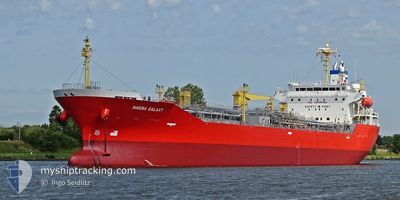
NAEBA GALAXY
Tanker
Current Trip
| Time Travelled | 4 days |
|---|---|
| Remaining Time | --- |
| Distance Travelled | 1280.79 nm |
| Remaining Distance | --- |
| AVG Speed | 13.9 Knop |
| MAX Speed | 16.5 Knop |
| AVG Wind | 13.3 knots |
| MAX Wind | 23 knots |
| MIN Temp | 21.3°C / 70.34°F |
| MAX Temp | 30.6°C / 87.08°F |
| Djupgående | 10 m |
| Position mottagen | 20 h, 49 m sen |
Current Position
| Longitud | -79.40199° |
|---|---|
| Latitude | 26.29688° |
| Status | Under way using engine |
| Fart | 16 Knop |
| Kurs | 0.9° |
| Område | North Atlantic Ocean |
| Station | T-AIS |
| Position mottagen | 20 h, 49 m sen |
Info
Information
The current position of NAEBA GALAXY is in North Atlantic Ocean with coordinates 26.29688° / -79.40199° as reported on 2024-05-01 01:11 by AIS to our vessel tracker app. The vessel's current speed is 16 Knop and is heading at the port of ANTWERP. The estimated time of arrival as calculated by MyShipTracking vessel tracking app is 2024-05-14 20:00 LT
The vessel NAEBA GALAXY (IMO: 9791169, MMSI: 563054800) is a Tanker It's sailing under the flag of [SG] Singapore.
In this page you can find informations about the vessels current position, last detected port calls, and current voyage information. If the vessels is not in coverage by AIS you will find the latest position.
The current position of NAEBA GALAXY is detected by our AIS receivers and we are not responsible for the reliability of the data. The last position was recorded while the vessel was in Coverage by the Ais receivers of our vessel tracking app.
The current draught of NAEBA GALAXY as reported by AIS is 10 meters
Weather
| Temperature | 22.8°C / 73.04°F |
|---|---|
| Wind Speed | 9 knots |
| Direction | 161° SSE |
| Pressure | 1014.8 hPa |
| Humidity | 79.8 % |
| Cloud Coverage | 8 % |
Featured Company
Last Port Calls
| Port | Arrival | Departure | Time In Port |
|---|---|---|---|
| 2024-04-26 18:02 | 2024-04-27 19:50 | 1 d | |
| 2024-04-22 02:44 | 2024-04-22 03:54 | 1 h | |
| 2024-04-20 16:33 | 2024-04-21 16:06 | 23 h | |
| 2024-04-13 15:03 | 2024-04-14 22:15 | 1 d | |
| 2024-04-05 07:53 | 2024-04-07 08:41 | 2 d | |
| 2024-03-29 09:09 | 2024-03-30 06:45 | 21 h | |
| 2024-03-24 05:15 | 2024-03-27 17:31 | 3 d | |
| 2024-03-20 07:21 | 2024-03-20 08:42 | 1 h | |
| 2024-03-13 08:48 | 2024-03-13 23:57 | 15 h | |
| 2024-03-09 07:54 | 2024-03-10 10:57 | 1 d |
Most Visited Ports (Last year)
| Port | Arrivals | |
|---|---|---|
| 12 | ||
| 7 | ||
| 5 | ||
| 4 | ||
| 3 | ||
| 3 |
Last Trips
| Origin | Departure | Destination | Arrival | Distance | |
|---|---|---|---|---|---|
| 2024-04-21 22:54 | 2024-04-26 13:02 | 581.52 nm | |||
| 2024-04-21 11:06 | 2024-04-21 21:44 | 102.65 nm | |||
| 2024-04-14 17:15 | 2024-04-20 11:33 | 70.89 nm | |||
| 2024-04-07 03:41 | 2024-04-13 10:03 | 75.94 nm | |||
| 2024-03-30 02:45 | 2024-04-05 02:53 | 1761.96 nm | |||
| 2024-03-27 12:31 | 2024-03-29 05:09 | 463.28 nm | |||
| 2024-03-20 03:42 | 2024-03-24 00:15 | 1137.18 nm | |||
| 2024-03-13 18:57 | 2024-03-20 02:21 | 178.00 nm | |||
| 2024-03-10 05:57 | 2024-03-13 03:48 | 710.06 nm | |||
| 2024-03-08 00:48 | 2024-03-09 01:54 | 72.23 nm |
Events
| Tid | Event | Detaljer | Position / Dest | Information |
|---|---|---|---|---|
| 2024-05-01 01:18 | Status ändrad | Default Under way using engine |
26.32655 / -79.40108
BE ANR
|
Fart: 16 kn Kurs: 0.9° |
| 2024-05-01 01:11 | UTANFÖR täckningsområde |
26.29688 / -79.40199
North Atlantic Ocean
BE ANR
|
Fart: 16 kn Kurs: 0.9° |
|
| 2024-05-01 00:28 | Status ändrad | Under way using engine Default |
26.10201 / -79.41355
BE ANR
|
Fart: 16.2 kn Kurs: 7° |
| 2024-05-01 00:20 | Status ändrad | Default Under way using engine |
26.06228 / -79.41773
BE ANR
|
Fart: 16 kn Kurs: 7.7° |
| 2024-04-30 22:03 | Byter havsområde | Bahamas part of the North Atlantic Ocean United States part of the Gulf of Mexico |
25.45767 / -79.52054
North Atlantic Ocean
BE ANR
|
Fart: 15.9 kn Kurs: 6.7° |
| 2024-04-30 22:03 | Status ändrad | Under way using engine Default |
25.45767 / -79.52054
BE ANR
|
Fart: 15.9 kn Kurs: 7° |
| 2024-04-30 21:52 | I täckningsområde |
25.45767 / -79.52054
North Atlantic Ocean
BE ANR
|
Fart: 15.9 kn Kurs: 6.7° |
|
| 2024-04-28 06:02 | Status ändrad | Default Under way using engine |
29.73202 / -89.99556
BE ANR
|
Fart: 13.7 kn Kurs: 149.8° |
| 2024-04-28 05:54 | UTANFÖR täckningsområde |
29.75321 / -90.02379
Gulf of Mexico
BE ANR
|
Fart: 13.7 kn Kurs: 149.8° |
|
| 2024-04-28 03:51 | Status ändrad | Under way using engine Default |
29.91255 / -90.13416
BE ANR
|
Fart: 13.9 kn Kurs: 149° |