
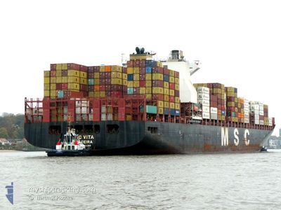
MSC VITA
Cargo A
Current Trip
| Trip Time | 3 days |
|---|---|
| Trip Distance | 1420.48 nm |
| AVG Speed | 17.8 Knop |
| MAX Speed | 20.5 Knop |
| Djupgående | 14.5 m |
| AVG Wind | 10.7 knots |
| MAX Wind | 24 knots |
| MIN Temp | 24.5°C / 76.1°F |
| MAX Temp | 28.1°C / 82.58°F |
| Position mottagen | 19 d sen |
Current Position
| Longitud | --- |
|---|---|
| Latitude | --- |
| Status | Under way using engine |
| Fart | 16.6 Knop |
| Kurs | 305.3° |
| Område | Malacca Strait |
| Station | T-AIS |
| Position mottagen | 19 d sen |
Info
Information
The current position of MSC VITA is in Malacca Strait with coordinates 2.25408° / 101.93202° as reported on 2025-11-20 11:59 by AIS to our vessel tracker app. The vessel's current speed is 16.6 Knop and is currently inside the port of COLOMBO.
The vessel MSC VITA (IMO: 9702089, MMSI: 255806493) is a Cargo A It's sailing under the flag of [PT] Portugal.
In this page you can find informations about the vessels current position, last detected port calls, and current voyage information. If the vessels is not in coverage by AIS you will find the latest position.
The current position of MSC VITA is detected by our AIS receivers and we are not responsible for the reliability of the data. The last position was recorded while the vessel was in Coverage by the Ais receivers of our vessel tracking app.
The current draught of MSC VITA as reported by AIS is 14.5 meters
Weather
| Temperature | 25.5°C / 77.9°F |
|---|---|
| Wind Speed | 16 knots |
| Direction | 29° NNE |
| Pressure | 1010.7 hPa |
| Humidity | 84.1 % |
| Cloud Coverage | 100 % |
Featured Company
Last Port Calls
| Port | Arrival | Departure | Time In Port |
|---|---|---|---|
| 2025-12-09 21:27 | |||
| 2025-12-04 10:57 | 2025-12-06 12:48 | 2 d | |
| 2025-11-29 03:47 | 2025-11-30 22:19 | 1 d | |
| 2025-11-26 02:35 | 2025-11-27 01:55 | 23 h | |
| 2025-11-01 20:04 | 2025-11-02 23:48 | 1 d | |
| 2025-10-10 06:30 | 2025-10-14 01:49 | 3 d |
Most Visited Ports (Last year)
| Port | Arrivals | |
|---|---|---|
| 8 | ||
| 4 | ||
| 3 | ||
| 3 | ||
| 3 | ||
| 2 |
Last Trips
| Origin | Departure | Destination | Arrival | Distance | |
|---|---|---|---|---|---|
| 2025-12-06 12:48 | 2025-12-09 21:27 | 1420.48 nm | |||
| 2025-11-30 22:19 | 2025-12-04 10:57 | 321.84 nm | |||
| 2025-11-27 01:55 | 2025-11-29 03:47 | 434.97 nm | |||
| 2025-11-02 23:48 | 2025-11-26 02:35 | 5752.01 nm | |||
| 2025-10-14 01:49 | 2025-11-01 20:04 | 6902.36 nm | |||
| 2025-09-28 17:46 | 2025-10-10 06:30 | 5414.46 nm |
Events
| Tid | Event | Detaljer | Position / Dest | Information |
|---|---|---|---|---|
| 2025-12-09 16:21 | STOPPAR förflyttning |
6.94671 / 79.83329
[LK] COLOMBO
|
Fart: 0.3 kn Kurs: 262° |
|
| 2025-12-09 15:57 | ANLÄNDER HAMN |
|
6.96141 / 79.83546
[LK] COLOMBO
|
Fart: 6.8 kn Kurs: 172° |
| 2025-12-06 07:48 | AVGÅTT HAMN |
|
24.78719 / 67.27546
INMUN
|
Fart: 7.2 kn Kurs: 313° |
| 2025-12-06 07:43 | STARTAR förflyttning |
24.76162 / 67.32261
[PK] PORT QASIM
|
Fart: 3.8 kn Kurs: 299° |
|
| 2025-12-04 05:57 | STOPPAR förflyttning |
24.76368 / 67.32316
[PK] PORT QASIM
|
Fart: 0.2 kn Kurs: 89° |
|
| 2025-12-04 05:57 | ANLÄNDER HAMN |
|
24.76368 / 67.32316
[PK] PORT QASIM
|
Fart: 1.7 kn Kurs: 77° |
| 2025-12-04 03:23 | STARTAR förflyttning | 16.2 nm, South of SALEHAABAD ISLAND |
24.53500 / 66.99333
INMUN
|
Fart: 6 kn Kurs: 107° |
| 2025-12-02 10:41 | STOPPAR förflyttning | 15.97 nm, South of SALEHAABAD ISLAND |
24.53860 / 66.98997
INMUN
|
Fart: 0.3 kn Kurs: 241° |
| 2025-12-02 08:09 | STARTAR förflyttning | 1.29 nm, East of SALEHAABAD ISLAND |
24.79854 / 66.99231
INMUN
|
Fart: 7.5 kn Kurs: 154° |
| 2025-12-01 16:04 | STOPPAR förflyttning | 0.95 nm, East of SALEHAABAD ISLAND |
24.80315 / 66.98704
INMUN
|
Fart: Kurs: 332° |