
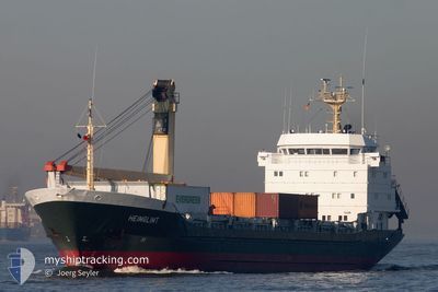
MOSTAFA B
General Cargo
Current Trip
| Time Travelled | 3 days |
|---|---|
| Remaining Time | --- |
| Distance Travelled | 356.00 nm |
| Remaining Distance | --- |
| AVG Speed | 9.2 Knop |
| MAX Speed | 12.7 Knop |
| AVG Wind | 9.3 knots |
| MAX Wind | 18.4 knots |
| MIN Temp | 9.8°C / 49.64°F |
| MAX Temp | 21.2°C / 70.16°F |
| Djupgående | 6.4 m |
| Position mottagen | 2 m sen |
Current Position
| Longitud | 28.93521° |
|---|---|
| Latitude | 40.97421° |
| Status | At anchor |
| Fart | |
| Kurs | 78° |
| Område | Sea of Marmara |
| Station | T-AIS |
| Position mottagen | 2 m sen |
Info
Information
The current position of MOSTAFA B is in Sea of Marmara with coordinates 40.97421° / 28.93521° as reported on 2024-05-17 12:56 by AIS to our vessel tracker app. The vessel's current speed is 0 Knop and is heading at the port of ALEXANDRIA. The estimated time of arrival as calculated by MyShipTracking vessel tracking app is 2024-05-21 18:00 LT
The vessel MOSTAFA B (IMO: 8403545, MMSI: 667002008) is a General Cargo that was built in 1985 ( 39 År gammal ). It's sailing under the flag of [SL] Sierra Leone.
In this page you can find informations about the vessels current position, last detected port calls, and current voyage information. If the vessels is not in coverage by AIS you will find the latest position.
The current position of MOSTAFA B is detected by our AIS receivers and we are not responsible for the reliability of the data. The last position was recorded while the vessel was in Coverage by the Ais receivers of our vessel tracking app.
The current draught of MOSTAFA B as reported by AIS is 6.4 meters
Weather
| Temperature | 21.2°C / 70.16°F |
|---|---|
| Wind Speed | 6 knots |
| Direction | 72° ENE |
| Pressure | 1017 hPa |
| Humidity | 50.4 % |
| Cloud Coverage | 74 % |
Featured Company
Last Port Calls
| Port | Arrival | Departure | Time In Port |
|---|---|---|---|
| 2024-05-08 10:12 | 2024-05-14 04:25 | 5 d | |
| 2024-04-26 15:32 | 2024-04-27 04:07 | 12 h | |
| 2024-04-23 20:05 | 2024-04-24 01:40 | 5 h | |
| 2024-04-23 08:05 | 2024-04-23 20:01 | 11 h | |
| 2024-04-15 18:07 | 2024-04-17 09:24 | 1 d | |
| 2024-04-13 07:05 | 2024-04-13 15:10 | 8 h | |
| 2024-04-11 10:21 | 2024-04-11 10:45 | 24 m | |
| 2024-03-23 11:33 | 2024-04-10 11:41 | 18 d | |
| 2024-03-22 05:56 | 2024-03-22 10:44 | 4 h | |
| 2024-03-14 02:23 | 2024-03-16 22:58 | 2 d |
Last Trips
| Origin | Departure | Destination | Arrival | Distance | |
|---|---|---|---|---|---|
| 2024-04-27 07:07 | 2024-05-08 13:12 | 122.96 nm | |||
| 2024-04-24 05:40 | 2024-04-26 18:32 | 571.94 nm | |||
| 2024-04-24 00:01 | 2024-04-24 00:05 | 0.72 nm | |||
| 2024-04-17 12:24 | 2024-04-23 12:05 | 391.90 nm | |||
| 2024-04-13 18:10 | 2024-04-15 21:07 | 8.98 nm | |||
| 2024-04-11 13:45 | 2024-04-13 10:05 | 396.32 nm | |||
| 2024-04-10 14:41 | 2024-04-11 13:21 | 68.86 nm | |||
| 2024-03-22 12:44 | 2024-03-23 13:33 | 74.12 nm | |||
| 2024-03-17 01:58 | 2024-03-22 07:56 | 394.29 nm | |||
| 2024-02-09 19:02 | 2024-03-14 05:23 | 982.72 nm |
Events
| Tid | Event | Detaljer | Position / Dest | Information |
|---|---|---|---|---|
| 2024-05-17 12:00 | STOPPAR förflyttning | 2.04 nm, East of ZEYTINBURNU |
40.97436 / 28.93733
ALEXANDRIA
|
Fart: 0.3 kn Kurs: 309° |
| 2024-05-17 11:59 | Status ändrad | At anchor Under way using engine |
40.97447 / 28.93745
ALEXANDRIA
|
Fart: 0.6 kn Kurs: 279° |
| 2024-05-17 09:52 | Byter havsområde | Turkish part of the Sea of Marmara Turkish part of the Black Sea |
41.23478 / 29.12481
Sea of Marmara
ALEXANDRIA
|
Fart: 5.5 kn Kurs: 164.9° |
| 2024-05-17 08:59 | STARTAR förflyttning | 3.02 nm, North West of RUMELI FENERI |
41.26712 / 29.06603
ALEXANDRIA
|
Fart: 3.2 kn Kurs: 98° |
| 2024-05-17 08:40 | Status ändrad | Under way using engine At anchor |
41.26817 / 29.06245
ALEXANDRIA
|
Fart: Kurs: 96° |
| 2024-05-17 07:33 | Status ändrad | At anchor Default |
41.26816 / 29.06230
ALEXANDRIA
|
Fart: 0.1 kn Kurs: 98° |
| 2024-05-17 07:27 | Status ändrad | Default At anchor |
41.26820 / 29.06224
ALEXANDRIA
|
Fart: 0.1 kn Kurs: 97° |
| 2024-05-17 04:48 | Status ändrad | At anchor Default |
41.26840 / 29.06238
ALEXANDRIA
|
Fart: Kurs: 98° |
| 2024-05-17 04:42 | Status ändrad | Default At anchor |
41.26838 / 29.06238
ALEXANDRIA
|
Fart: 0.1 kn Kurs: 101° |
| 2024-05-17 00:00 | Status ändrad | At anchor Default |
41.26846 / 29.06242
ALEXANDRIA
|
Fart: Kurs: -1° |