
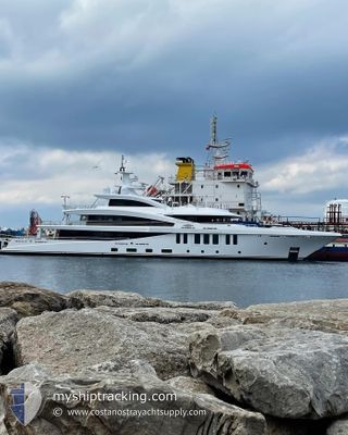
MOONSTONE
Pleasure Craft
Current Trip
| Time Travelled | 11 days |
|---|---|
| Remaining Time | 1 day |
| Distance Travelled | 2917.33 nm |
| Remaining Distance | 909.88 nm |
| AVG Speed | 13.1 Knop |
| MAX Speed | 15.1 Knop |
| AVG Wind | 10 knots |
| MAX Wind | 15 knots |
| MIN Temp | 18.1°C / 64.58°F |
| MAX Temp | 25.6°C / 78.08°F |
| Djupgående | 3.3 m |
| Position mottagen | 1 d sen |
Current Position
| Longitud | -23.89368° |
|---|---|
| Latitude | 37.09063° |
| Status | Under way using engine |
| Fart | 13.8 Knop |
| Kurs | 88.3° |
| Område | North Atlantic Ocean |
| Station | T-AIS |
| Position mottagen | 1 d sen |
Info
Information
The current position of MOONSTONE is in North Atlantic Ocean with coordinates 37.09063° / -23.89368° as reported on 2024-05-13 11:31 by AIS to our vessel tracker app. The vessel's current speed is 13.8 Knop and is heading at the port of GIBRALTAR. The estimated time of arrival as calculated by MyShipTracking vessel tracking app is 2024-05-16 07:38 LT
The vessel MOONSTONE (IMO: 9870379, MMSI: 319210300) is a Pleasure Craft It's sailing under the flag of [KY] Cayman Is.
In this page you can find informations about the vessels current position, last detected port calls, and current voyage information. If the vessels is not in coverage by AIS you will find the latest position.
The current position of MOONSTONE is detected by our AIS receivers and we are not responsible for the reliability of the data. The last position was recorded while the vessel was in Coverage by the Ais receivers of our vessel tracking app.
The current draught of MOONSTONE as reported by AIS is 3.3 meters
Weather
| Temperature | 18.9°C / 66.02°F |
|---|---|
| Wind Speed | 13 knots |
| Direction | 330° NNW |
| Pressure | 1026.8 hPa |
| Humidity | 91.1 % |
| Cloud Coverage | 100 % |
Featured Company
Last Port Calls
| Port | Arrival | Departure | Time In Port |
|---|---|---|---|
| 2024-04-24 19:36 | 2024-05-03 22:08 | 9 d | |
| 2024-04-24 19:21 | |||
| 2024-03-12 20:26 | 2024-03-24 14:56 | 11 d | |
| 2024-03-05 16:24 | 2024-03-10 17:23 | 5 d |
Most Visited Ports (Last year)
| Port | Arrivals | |
|---|---|---|
| 3 | ||
| 1 | ||
| 1 | ||
| 1 | ||
| 1 | ||
| 1 |
Last Trips
| Origin | Departure | Destination | Arrival | Distance | |
|---|---|---|---|---|---|
| 2024-03-24 10:56 | 2024-04-24 15:36 | 972.17 nm | |||
| 2024-03-24 10:56 | 2024-04-24 15:21 | 971.88 nm | |||
| 2024-03-10 13:23 | 2024-03-12 16:26 | 625.39 nm | |||
| 2024-02-19 17:53 | 2024-03-05 12:24 | 174.05 nm |
Events
| Tid | Event | Detaljer | Position / Dest | Information |
|---|---|---|---|---|
| 2024-05-13 11:31 | UTANFÖR täckningsområde |
37.09063 / -23.89368
North Atlantic Ocean
GIBRALTAR
|
Fart: 13.8 kn Kurs: 88.3° |
|
| 2024-05-13 03:17 | I täckningsområde |
37.05313 / -26.29715
North Atlantic Ocean
GIBRALTAR
|
Fart: 14.5 kn Kurs: 87.8° |
|
| 2024-05-13 02:14 | UTANFÖR täckningsområde |
37.04310 / -26.60365
North Atlantic Ocean
GIBRALTAR
|
Fart: 13.8 kn Kurs: 85.8° |
|
| 2024-05-12 23:46 | I täckningsområde |
37.01783 / -27.32760
North Atlantic Ocean
GIBRALTAR
|
Fart: 14.3 kn Kurs: 85.3° |
|
| 2024-05-12 22:14 | UTANFÖR täckningsområde |
37.00230 / -27.77313
North Atlantic Ocean
GIBRALTAR
|
Fart: 13.6 kn Kurs: 87.3° |
|
| 2024-05-12 22:14 | I täckningsområde |
37.00230 / -27.77313
North Atlantic Ocean
GIBRALTAR
|
Fart: 13.6 kn Kurs: 87.3° |
|
| 2024-05-12 18:20 | UTANFÖR täckningsområde |
36.95263 / -28.88137
North Atlantic Ocean
GIBRALTAR
|
Fart: 13.4 kn Kurs: 87.3° |
|
| 2024-05-12 17:22 | Byter havsområde | Portuguese (Azores) part of the North Atlantic Ocean United States part of the North Atlantic Ocean |
36.93858 / -29.16097
North Atlantic Ocean
GIBRALTAR
|
Fart: 13.4 kn Kurs: 85.7° |
| 2024-05-12 17:22 | I täckningsområde |
36.93858 / -29.16097
North Atlantic Ocean
GIBRALTAR
|
Fart: 13.4 kn Kurs: 85.7° |