
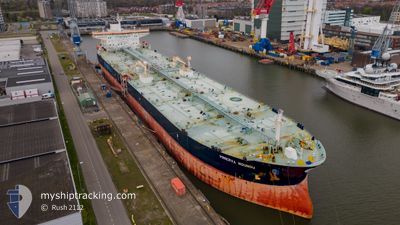
MINERVA NOUNOU
Crude Oil Tanker
Current Trip
| Time Travelled | 20 days |
|---|---|
| Remaining Time | 1 h, 17 mins |
| Distance Travelled | 5077.25 nm |
| Remaining Distance | 12.93 nm |
| AVG Speed | 12 Knop |
| MAX Speed | 14.4 Knop |
| AVG Wind | 16.9 knots |
| MAX Wind | 32.7 knots |
| MIN Temp | 10.7°C / 51.26°F |
| MAX Temp | 28°C / 82.4°F |
| Djupgående | 13.5 m |
| Position mottagen | 1 d sen |
Current Position
| Longitud | --- |
|---|---|
| Latitude | --- |
| Status | Under way using engine |
| Fart | 2.5 Knop |
| Kurs | 291° |
| Område | Bay of Biscay |
| Station | T-AIS |
| Position mottagen | 1 d sen |
Info
Information
The current position of MINERVA NOUNOU is in Bay of Biscay with coordinates 43.66735° / -3.16910° as reported on 2025-12-05 07:20 by AIS to our vessel tracker app. The vessel's current speed is 2.5 Knop and is heading at the port of BILBAO. The estimated time of arrival as calculated by MyShipTracking vessel tracking app is 2025-12-06 22:20 LT
The vessel MINERVA NOUNOU (IMO: 9309423, MMSI: 248884000) is a Crude Oil Tanker that was built in 2006 ( 19 År gammal ). It's sailing under the flag of [MT] Malta.
In this page you can find informations about the vessels current position, last detected port calls, and current voyage information. If the vessels is not in coverage by AIS you will find the latest position.
The current position of MINERVA NOUNOU is detected by our AIS receivers and we are not responsible for the reliability of the data. The last position was recorded while the vessel was in Coverage by the Ais receivers of our vessel tracking app.
The current draught of MINERVA NOUNOU as reported by AIS is 13.5 meters
Weather
| Temperature | 14.8°C / 58.64°F |
|---|---|
| Wind Speed | 9 knots |
| Direction | 137° SE |
| Pressure | 1017.4 hPa |
| Humidity | 86.9 % |
| Cloud Coverage | 100 % |
Featured Company
Most Visited Ports (Last year)
| Port | Arrivals | |
|---|---|---|
| 5 | ||
| 3 | ||
| 2 | ||
| 2 | ||
| 1 | ||
| 1 |
Last Trips
| Origin | Departure | Destination | Arrival | Distance | |
|---|---|---|---|---|---|
| 2025-11-02 12:01 | 2025-11-15 02:00 | 101.83 nm | |||
| 2025-09-16 02:12 | 2025-10-31 11:23 | 13034.92 nm |
Events
| Tid | Event | Detaljer | Position / Dest | Information |
|---|---|---|---|---|
| 2025-12-06 17:59 | STARTAR förflyttning | 12.85 nm, North of BILBAO |
43.56881 / -2.99360
ES BIO
|
Fart: 6 kn Kurs: 82° |
| 2025-12-06 04:19 | STOPPAR förflyttning | 14.51 nm, North West of BERMEO |
43.61106 / -2.91698
ES BIO
|
Fart: 0.3 kn Kurs: 290° |
| 2025-12-05 07:47 | STARTAR förflyttning | 18.47 nm, North East of LAREDO |
43.67538 / -3.18774
ES BIO
|
Fart: 3.2 kn Kurs: 77° |
| 2025-12-05 07:27 | Status ändrad | Default Under way using engine |
43.66864 / -3.17485
ES BIO
|
Fart: 2.5 kn Kurs: 291° |
| 2025-12-05 07:20 | UTANFÖR täckningsområde |
43.66735 / -3.16910
Bay of Biscay
|
Fart: 2.5 kn Kurs: 290.6° |
|
| 2025-12-05 06:13 | Status ändrad | Under way using engine Default |
43.65599 / -3.11500
ES BIO
|
Fart: 1.9 kn Kurs: 290° |
| 2025-12-05 06:03 | Status ändrad | Default Under way using engine |
43.65482 / -3.10790
ES BIO
|
Fart: 1.5 kn Kurs: 290° |
| 2025-12-05 05:56 | Status ändrad | Under way using engine Default |
43.65428 / -3.10390
ES BIO
|
Fart: 1.5 kn Kurs: 288° |
| 2025-12-05 05:55 | I täckningsområde |
43.65428 / -3.10390
Bay of Biscay
|
Fart: 1.5 kn Kurs: 275.2° |
|
| 2025-12-04 16:23 | STOPPAR förflyttning | 16.13 nm, North of BERMEO |
43.67022 / -2.84811
ES BIO
|
Fart: 0.3 kn Kurs: 287° |