
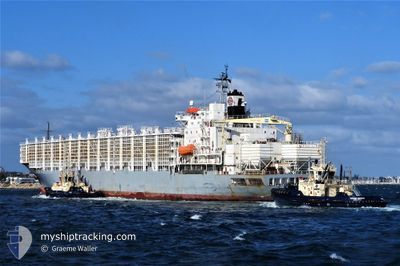
MAYSORA
Livestock Carrier
Current Trip
| Time Travelled | 8 days |
|---|---|
| Remaining Time | 3 days |
| Distance Travelled | 2077.49 nm |
| Remaining Distance | 1415.82 nm |
| AVG Speed | 13.6 Knop |
| MAX Speed | 16 Knop |
| AVG Wind | 9.5 knots |
| MAX Wind | 17.7 knots |
| MIN Temp | 9.6°C / 49.28°F |
| MAX Temp | 25.5°C / 77.9°F |
| Djupgående | 9.2 m |
| Position mottagen | 6 d sen |
Current Position
| Longitud | --- |
|---|---|
| Latitude | --- |
| Status | Under way using engine |
| Fart | 14.1 Knop |
| Kurs | 69.6° |
| Område | Persian Gulf |
| Station | T-AIS |
| Position mottagen | 6 d sen |
Info
Information
The current position of MAYSORA is in Persian Gulf with coordinates 26.22767° / 55.64467° as reported on 2026-01-01 17:34 by AIS to our vessel tracker app. The vessel's current speed is 14.1 Knop and is heading at the port of FUJAIRAH. The estimated time of arrival as calculated by MyShipTracking vessel tracking app is 2026-01-12 18:43 LT
The vessel MAYSORA (IMO: 8310542, MMSI: 511100869) is a Livestock Carrier that was built in 1989 ( 37 År gammal ). It's sailing under the flag of [PW] Palau.
In this page you can find informations about the vessels current position, last detected port calls, and current voyage information. If the vessels is not in coverage by AIS you will find the latest position.
The current position of MAYSORA is detected by our AIS receivers and we are not responsible for the reliability of the data. The last position was recorded while the vessel was in Coverage by the Ais receivers of our vessel tracking app.
The current draught of MAYSORA as reported by AIS is 9.2 meters
Weather
| Temperature | 25°C / 77°F |
|---|---|
| Wind Speed | 13 knots |
| Direction | 88° E |
| Pressure | 1017.3 hPa |
| Humidity | 66.4 % |
| Cloud Coverage | 6 % |
Featured Company
Last Port Calls
| Port | Arrival | Departure | Time In Port |
|---|---|---|---|
| 2025-12-28 03:20 | 2025-12-31 09:01 | 3 d | |
| 2025-12-16 08:17 | 2025-12-16 17:03 | 8 h | |
| 2025-11-23 22:31 | 2025-11-27 14:52 | 3 d |
Most Visited Ports (Last year)
| Port | Arrivals | |
|---|---|---|
| 4 | ||
| 3 | ||
| 3 | ||
| 2 | ||
| 2 | ||
| 1 |
Last Trips
| Origin | Departure | Destination | Arrival | Distance | |
|---|---|---|---|---|---|
| 2025-11-27 14:52 | 2025-12-28 03:20 | 8706.75 nm | |||
| 2025-11-27 14:52 | 2025-12-16 08:17 | 5275.22 nm | |||
| 2025-08-31 19:37 | 2025-11-23 22:31 | 336.75 nm |
Events
| Tid | Event | Detaljer | Position / Dest | Information |
|---|---|---|---|---|
| 2026-01-04 14:59 | STARTAR förflyttning | 8.36 nm, East of KHORFAKKAN |
25.34278 / 56.51473
AE FJR
|
Fart: 4.8 kn Kurs: 137° |
| 2026-01-03 01:25 | STOPPAR förflyttning | 8.06 nm, East of KHORFAKKAN |
25.34644 / 56.50962
AE FJR
|
Fart: Kurs: 253° |
| 2026-01-02 23:56 | STARTAR förflyttning | 14.96 nm, East of KHORFAKKAN |
25.30577 / 56.63114
AE FJR
|
Fart: 4.1 kn Kurs: 285° |
| 2026-01-02 23:20 | STOPPAR förflyttning | 15.19 nm, East of KHORFAKKAN |
25.31167 / 56.63667
AE FJR
|
Fart: Kurs: -1° |
| 2026-01-02 22:16 | STARTAR förflyttning | 14.04 nm, East of KHORFAKKAN |
25.32164 / 56.61713
AE FJR
|
Fart: 4.6 kn Kurs: 107° |
| 2026-01-02 21:47 | STOPPAR förflyttning | 13.25 nm, East of KHORFAKKAN |
25.31833 / 56.60166
AE FJR
|
Fart: Kurs: -1° |
| 2026-01-02 20:20 | STARTAR förflyttning | 8.2 nm, North East of FUJAIRAH |
25.24423 / 56.47265
AE FJR
|
Fart: 3.2 kn Kurs: 81° |
| 2026-01-02 04:57 | STOPPAR förflyttning | 8.32 nm, North East of FUJAIRAH |
25.24904 / 56.47045
AE FJR
|
Fart: 0.2 kn Kurs: 198° |
| 2026-01-01 17:41 | Status ändrad | Default Under way using engine |
26.23719 / 55.67389
AE FJR
|
Fart: 14.1 kn Kurs: 69.6° |
| 2026-01-01 17:34 | UTANFÖR täckningsområde |
26.22767 / 55.64467
Persian Gulf
AE FJR
|
Fart: 14.1 kn Kurs: 69.6° |