
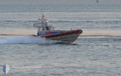
KNRM-ULY
Search and Rescue vessel
Current Trip
WESTKAPELLE
| Time Travelled | 1 day |
|---|---|
| Remaining Time | --- |
| Distance Travelled | 11.14 nm |
| Remaining Distance | --- |
| AVG Speed | 22.3 Knop |
| MAX Speed | 22.3 Knop |
| AVG Wind | 18.7 knots |
| MAX Wind | 19.5 knots |
| MIN Temp | 4.7°C / 40.46°F |
| MAX Temp | 6.1°C / 42.98°F |
| Djupgående | 1 m |
| Position mottagen | 1 d sen |
Current Position
| Longitud | --- |
|---|---|
| Latitude | --- |
| Status | Pushing Ahead - Towing |
| Fart | |
| Kurs | 35° |
| Område | North Sea |
| Station | T-AIS |
| Position mottagen | 1 d sen |
Info
Information
The current position of KNRM-ULY is in North Sea with coordinates 51.52258° / 3.44121° as reported on 2026-01-07 20:29 by AIS to our vessel tracker app. The vessel's current speed is 0 Knop
The vessel KNRM-ULY (MMSI: 244100267) is a Search and Rescue vessel It's sailing under the flag of [NL] Netherlands.
In this page you can find informations about the vessels current position, last detected port calls, and current voyage information. If the vessels is not in coverage by AIS you will find the latest position.
The current position of KNRM-ULY is detected by our AIS receivers and we are not responsible for the reliability of the data. The last position was recorded while the vessel was in Coverage by the Ais receivers of our vessel tracking app.
The current draught of KNRM-ULY as reported by AIS is 1 meters
Weather
| Temperature | 6°C / 42.8°F |
|---|---|
| Wind Speed | 19 knots |
| Direction | 287° WNW |
| Pressure | 1004 hPa |
| Humidity | 77.5 % |
| Cloud Coverage | 100 % |
Featured Company
Last Port Calls
| Port | Arrival | Departure | Time In Port |
|---|---|---|---|
| 2026-01-07 19:53 | 2026-01-07 20:37 | 43 m | |
| 2026-01-05 19:51 | 2026-01-05 20:09 | 17 m | |
| 2025-12-17 19:39 | 2025-12-17 20:18 | 38 m | |
| 2025-12-15 19:51 | 2025-12-15 20:46 | 55 m | |
| 2025-12-03 19:49 | 2025-12-03 20:12 | 22 m | |
| 2025-12-01 20:07 | 2025-12-01 20:36 | 28 m | |
| 2025-11-20 20:05 | 2025-11-20 20:24 | 19 m | |
| 2025-11-18 20:16 | 2025-11-18 21:06 | 50 m | |
| 2025-11-13 20:00 | 2025-11-13 20:12 | 11 m | |
| 2025-11-06 19:52 | 2025-11-06 20:36 | 43 m |
Most Visited Ports (Last year)
| Port | Arrivals | |
|---|---|---|
| 13 | ||
| 10 | ||
| 6 | ||
| 2 |
Last Trips
| Origin | Departure | Destination | Arrival | Distance | |
|---|---|---|---|---|---|
| 2026-01-05 20:09 | 2026-01-07 19:53 | 20.95 nm | |||
| 2025-12-17 20:18 | 2026-01-05 19:51 | 86.72 nm | |||
| 2025-12-15 20:46 | 2025-12-17 19:39 | 21.19 nm | |||
| 2025-12-03 20:12 | 2025-12-15 19:51 | 63.78 nm | |||
| 2025-12-01 20:36 | 2025-12-03 19:49 | 18.82 nm | |||
| 2025-11-20 20:24 | 2025-12-01 20:07 | 17.93 nm | |||
| 2025-11-18 21:06 | 2025-11-20 20:05 | 18.99 nm | |||
| 2025-11-13 20:12 | 2025-11-18 20:16 | 29.76 nm | |||
| 2025-11-06 20:36 | 2025-11-13 20:00 | 62.49 nm | |||
| 2025-09-23 20:12 | 2025-11-06 19:52 | 74.56 nm |
Events
| Tid | Event | Detaljer | Position / Dest | Information |
|---|---|---|---|---|
| 2026-01-07 20:29 | UTANFÖR täckningsområde |
51.52258 / 3.44121
North Sea
|
Fart: Kurs: 35° |
|
| 2026-01-07 20:07 | STOPPAR förflyttning | 6.68 nm, West of MIDDELBURG |
51.52098 / 3.44236
WESTKAPELLE
|
Fart: 0.3 kn Kurs: 227° |
| 2026-01-07 19:37 | AVGÅTT HAMN |
|
51.44652 / 3.66998
WESTKAPELLE
|
Fart: 30.3 kn Kurs: 206° |
| 2026-01-07 19:24 | STARTAR förflyttning |
51.45242 / 3.70853
[NL] VLISSINGEN
|
Fart: 6 kn Kurs: 272° |
|
| 2026-01-07 19:09 | STOPPAR förflyttning |
51.45335 / 3.71126
[NL] VLISSINGEN
|
Fart: 0.2 kn Kurs: 250° |
|
| 2026-01-07 18:53 | ANLÄNDER HAMN |
|
51.44803 / 3.67285
[NL] VLISSINGEN
|
Fart: 30.3 kn Kurs: 33.3° |
| 2026-01-07 18:27 | STARTAR förflyttning | 6.58 nm, West of MIDDELBURG |
51.51776 / 3.44397
WESTKAPELLE
|
Fart: 8.8 kn Kurs: 218.1° |
| 2026-01-07 18:26 | STOPPAR förflyttning | 6.49 nm, West of MIDDELBURG |
51.51878 / 3.44666
WESTKAPELLE
|
Fart: Kurs: 253° |
| 2026-01-07 18:22 | STARTAR förflyttning | 6.63 nm, West of MIDDELBURG |
51.52143 / 3.44377
WESTKAPELLE
|
Fart: 6 kn Kurs: 132.6° |
| 2026-01-07 18:15 | I täckningsområde |
51.52258 / 3.44119
North Sea
|
Fart: Kurs: 30° |