
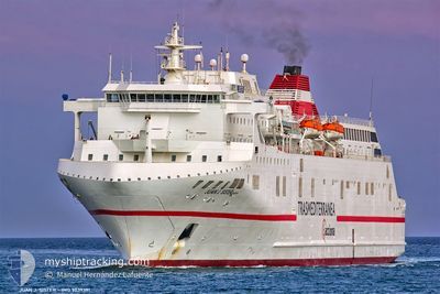
JUAN J SISTER
Ro-Ro/Passenger Ship
Current Trip
| Trip Time | 7 h, 24 mins |
|---|---|
| Trip Distance | 95.45 nm |
| AVG Speed | 12.5 Knop |
| MAX Speed | 16.7 Knop |
| Djupgående | 5.9 m |
| AVG Wind | 22.9 knots |
| MAX Wind | 31 knots |
| MIN Temp | 14.4°C / 57.92°F |
| MAX Temp | 17.1°C / 62.78°F |
| Position mottagen | 2 h, 15 m sen |
Current Position
| Longitud | --- |
|---|---|
| Latitude | --- |
| Status | Under way using engine |
| Fart | 15.2 Knop |
| Kurs | 1.4° |
| Område | Alboran Sea |
| Station | T-AIS |
| Position mottagen | 2 h, 15 m sen |
Info
Information
The current position of JUAN J SISTER is in Alboran Sea with coordinates 36.70844° / -2.46180° as reported on 2025-12-05 06:56 by AIS to our vessel tracker app. The vessel's current speed is 15.2 Knop and is currently inside the port of ALMERIA.
The vessel JUAN J SISTER (IMO: 9039391, MMSI: 224647000) is a Ro-Ro/Passenger Ship that was built in 1993 ( 32 År gammal ). It's sailing under the flag of [ES] Spain.
In this page you can find informations about the vessels current position, last detected port calls, and current voyage information. If the vessels is not in coverage by AIS you will find the latest position.
The current position of JUAN J SISTER is detected by our AIS receivers and we are not responsible for the reliability of the data. The last position was recorded while the vessel was in Coverage by the Ais receivers of our vessel tracking app.
The current draught of JUAN J SISTER as reported by AIS is 5.9 meters
Weather
| Temperature | 15.7°C / 60.26°F |
|---|---|
| Wind Speed | 3 knots |
| Direction | 4° N |
| Pressure | 1019.6 hPa |
| Humidity | 39.8 % |
| Cloud Coverage | 100 % |
Featured Company
Last Port Calls
| Port | Arrival | Departure | Time In Port |
|---|---|---|---|
| 2025-12-05 08:22 | |||
| 2025-12-04 21:14 | 2025-12-05 00:58 | 3 h | |
| 2025-12-04 08:14 | 2025-12-04 13:23 | 5 h | |
| 2025-12-03 19:08 | 2025-12-04 00:42 | 5 h | |
| 2025-12-02 12:55 | 2025-12-03 10:27 | 21 h | |
| 2025-12-01 07:46 | 2025-12-01 23:39 | 15 h | |
| 2025-11-30 08:39 | 2025-11-30 22:18 | 13 h | |
| 2025-11-29 08:05 | 2025-11-30 00:03 | 15 h | |
| 2025-11-28 08:38 | 2025-11-28 22:43 | 14 h | |
| 2025-11-27 07:57 | 2025-11-28 00:21 | 16 h |
Most Visited Ports (Last year)
| Port | Arrivals | |
|---|---|---|
| 305 | ||
| 305 | ||
| 164 | ||
| 158 | ||
| 3 | ||
| 3 |
Last Trips
| Origin | Departure | Destination | Arrival | Distance | |
|---|---|---|---|---|---|
| 2025-12-05 00:58 | 2025-12-05 08:22 | 95.45 nm | |||
| 2025-12-04 13:23 | 2025-12-04 21:14 | 105.86 nm | |||
| 2025-12-04 00:42 | 2025-12-04 08:14 | 95.43 nm | |||
| 2025-12-03 10:27 | 2025-12-03 19:08 | 105.78 nm | |||
| 2025-12-01 23:39 | 2025-12-02 12:55 | 98.41 nm | |||
| 2025-11-30 22:18 | 2025-12-01 07:46 | 95.06 nm | |||
| 2025-11-30 00:03 | 2025-11-30 08:39 | 95.02 nm | |||
| 2025-11-28 22:43 | 2025-11-29 08:05 | 94.57 nm | |||
| 2025-11-28 00:21 | 2025-11-28 08:38 | 94.44 nm | |||
| 2025-11-26 22:39 | 2025-11-27 07:57 | 94.57 nm |
Events
| Tid | Event | Detaljer | Position / Dest | Information |
|---|---|---|---|---|
| 2025-12-05 08:01 | STOPPAR förflyttning |
36.83375 / -2.46972
[ES] ALMERIA
|
Fart: Kurs: 230° |
|
| 2025-12-05 07:22 | ANLÄNDER HAMN |
|
36.81976 / -2.45654
[ES] ALMERIA
|
Fart: 9.5 kn Kurs: 341° |
| 2025-12-05 07:07 | Status ändrad | Default Under way using engine |
36.75977 / -2.45712
ES LEI
|
Fart: 15.2 kn Kurs: 1.4° |
| 2025-12-05 06:56 | UTANFÖR täckningsområde |
36.70844 / -2.46180
Alboran Sea
[ES] ALMERIA
|
Fart: 15.2 kn Kurs: 1.4° |
|
| 2025-12-05 06:53 | Status ändrad | Under way using engine Default |
36.70044 / -2.46234
ES LEI
|
Fart: 13.4 kn Kurs: 359° |
| 2025-12-05 06:51 | Status ändrad | Default Under way using engine |
36.69402 / -2.46312
ES LEI
|
Fart: 13.9 kn Kurs: 4° |
| 2025-12-05 06:45 | Status ändrad | Under way using engine Default |
36.67228 / -2.46508
ES LEI
|
Fart: 13.8 kn Kurs: 5° |
| 2025-12-05 06:13 | Status ändrad | Default Under way using engine |
36.54727 / -2.47983
ES LEI
|
Fart: 14.2 kn Kurs: 13.4° |
| 2025-12-05 06:09 | Status ändrad | Under way using engine Default |
36.53095 / -2.48275
ES LEI
|
Fart: 15.6 kn Kurs: 6° |
| 2025-12-05 06:03 | I täckningsområde |
36.53095 / -2.48275
Alboran Sea
|
Fart: 14.2 kn Kurs: 13.4° |