
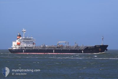
JIPRO NEFTIS
Oil/Chemical Tanker
Current Trip
| Time Travelled | 7 days |
|---|---|
| Remaining Time | --- |
| Distance Travelled | 2272.98 nm |
| Remaining Distance | --- |
| AVG Speed | 12.8 Knop |
| MAX Speed | 17.3 Knop |
| AVG Wind | 6.3 knots |
| MAX Wind | 17.1 knots |
| MIN Temp | 22.9°C / 73.22°F |
| MAX Temp | 30.5°C / 86.9°F |
| Djupgående | 11.5 m |
| Position mottagen | 2 d sen |
Current Position
| Longitud | 103.50276° |
|---|---|
| Latitude | 1.22323° |
| Status | Under way using engine |
| Fart | 15.6 Knop |
| Kurs | 283.3° |
| Område | Singapore Strait |
| Station | T-AIS |
| Position mottagen | 2 d sen |
Info
Information
The current position of JIPRO NEFTIS is in Singapore Strait with coordinates 1.22323° / 103.50276° as reported on 2024-05-07 07:16 by AIS to our vessel tracker app. The vessel's current speed is 15.6 Knop and is heading at the port of JORF LASFAR. The estimated time of arrival as calculated by MyShipTracking vessel tracking app is 2024-06-10 04:00 LT
The vessel JIPRO NEFTIS (IMO: 9459292, MMSI: 370328000) is a Oil/Chemical Tanker that was built in 2011 ( 13 År gammal ). It's sailing under the flag of [PA] Panama.
In this page you can find informations about the vessels current position, last detected port calls, and current voyage information. If the vessels is not in coverage by AIS you will find the latest position.
The current position of JIPRO NEFTIS is detected by our AIS receivers and we are not responsible for the reliability of the data. The last position was recorded while the vessel was in Coverage by the Ais receivers of our vessel tracking app.
The current draught of JIPRO NEFTIS as reported by AIS is 11.5 meters
Weather
| Temperature | 29.9°C / 85.82°F |
|---|---|
| Wind Speed | 9 knots |
| Direction | 315° NW |
| Pressure | 1010 hPa |
| Humidity | 73.7 % |
| Cloud Coverage | 25 % |
Featured Company
Most Visited Ports (Last year)
| Port | Arrivals | |
|---|---|---|
| 8 | ||
| 5 | ||
| 4 | ||
| 3 | ||
| 3 | ||
| 2 |
Events
| Tid | Event | Detaljer | Position / Dest | Information |
|---|---|---|---|---|
| 2024-05-09 08:41 | STARTAR förflyttning |
5.24013 / 94.04263
SG SIN>MA JFL
|
Fart: 9.9 kn Kurs: 221° |
|
| 2024-05-09 06:46 | STOPPAR förflyttning |
5.23909 / 94.05058
SG SIN>MA JFL
|
Fart: 0.1 kn Kurs: 139° |
|
| 2024-05-07 07:20 | Status ändrad | Default Under way using engine |
1.22818 / 103.48294
SG SIN>MA JFL
|
Fart: 15.6 kn Kurs: 283.3° |
| 2024-05-07 07:16 | UTANFÖR täckningsområde |
1.22323 / 103.50276
Singapore Strait
|
Fart: 15.6 kn Kurs: 283.3° |
|
| 2024-05-07 06:55 | Byter havsområde | Malaysian part of the Singapore Strait Indonesian part of the Singapore Strait |
1.20285 / 103.58660
Singapore Strait
|
Fart: 15.1 kn Kurs: 283.4° |
| 2024-05-07 06:48 | ETA ändrat | 2024/06/10 04:00 2024/06/11 06:00 |
1.19511 / 103.61759
SG SIN>MA JFL
|
Fart: 14.8 kn Kurs: 287.3° |
| 2024-05-07 06:34 | Byter havsområde | Indonesian part of the Singapore Strait Singaporean part of the Singapore Strait |
1.18051 / 103.66639
Singapore Strait
|
Fart: 12.4 kn Kurs: 286.1° |
| 2024-05-07 06:06 | STARTAR förflyttning | 4.58 nm, South West of BUKOM ISLAND |
1.17306 / 103.71067
SG SIN>MA JFL
|
Fart: 3.1 kn Kurs: 251° |
| 2024-05-07 06:03 | ETA ändrat | 2024/06/11 06:00 2024/06/11 16:00 |
1.17417 / 103.71274
SG SIN>MA JFL
|
Fart: 2.3 kn Kurs: 240° |
| 2024-05-07 05:53 | Status ändrad | Under way using engine At anchor |
1.17526 / 103.71406
SG SIN>MA JFL
|
Fart: 0.1 kn Kurs: 227° |