
ID PIONEER
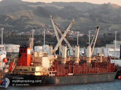
Bulk Carrier
Current Trip
| Trip Time | 23 mins |
|---|---|
| Trip Distance | 0.89 nm |
| AVG Speed | 2.2 Knop |
| MAX Speed | 2.2 Knop |
| Djupgående | 8.4 m |
| AVG Wind | 5.6 knots |
| MAX Wind | 5.8 knots |
| MIN Temp | 28.8°C / 83.84°F |
| MAX Temp | 28.8°C / 83.84°F |
| Position mottagen | 3 m sen |
Current Position
| Longitud | -80.12083° |
|---|---|
| Latitude | 26.07467° |
| Status | Moored |
| Fart | 0.1 Knop |
| Kurs | 270° |
| Område | North Atlantic Ocean |
| Station | T-AIS |
| Position mottagen | 3 m sen |
Info
Information
The current position of ID PIONEER is in North Atlantic Ocean with coordinates 26.07467° / -80.12083° as reported on 2024-05-18 01:16 by AIS to our vessel tracker app. The vessel's current speed is 0.1 Knop and is currently inside the port of FORT LAUDERDALE.
The vessel ID PIONEER (IMO: 9665700, MMSI: 229969000) is a Bulk Carrier that was built in 2012 ( 12 År gammal ). It's sailing under the flag of [MT] Malta.
In this page you can find informations about the vessels current position, last detected port calls, and current voyage information. If the vessels is not in coverage by AIS you will find the latest position.
The current position of ID PIONEER is detected by our AIS receivers and we are not responsible for the reliability of the data. The last position was recorded while the vessel was in Coverage by the Ais receivers of our vessel tracking app.
The current draught of ID PIONEER as reported by AIS is 8.4 meters
Weather
| Temperature | 28.2°C / 82.76°F |
|---|---|
| Wind Speed | 14 knots |
| Direction | 179° S |
| Pressure | 1013.3 hPa |
| Humidity | 85.8 % |
| Cloud Coverage | 2 % |
Featured Company
Last Port Calls
| Port | Arrival | Departure | Time In Port |
|---|---|---|---|
| 2024-05-17 02:55 | |||
| 2024-05-17 02:21 | 2024-05-17 02:32 | 11 m | |
| 2024-05-11 17:34 | 2024-05-12 12:21 | 18 h | |
| 2024-05-01 20:58 | 2024-05-11 14:45 | 9 d | |
| 2024-05-01 17:34 | 2024-05-01 17:54 | 20 m | |
| 2024-04-08 15:01 | |||
| 2024-03-11 06:23 | 2024-03-11 13:20 | 6 h | |
| 2024-03-07 00:22 | 2024-03-10 17:47 | 3 d | |
| 2024-03-06 07:38 | 2024-03-06 19:33 | 11 h | |
| 2024-03-03 14:13 | 2024-03-04 19:29 | 1 d |
Most Visited Ports (Last year)
| Port | Arrivals | |
|---|---|---|
| 5 | ||
| 2 | ||
| 2 | ||
| 2 | ||
| 2 | ||
| 2 |
Last Trips
| Origin | Departure | Destination | Arrival | Distance | |
|---|---|---|---|---|---|
| 2024-05-17 02:32 | 2024-05-17 02:55 | 0.89 nm | |||
| 2024-05-12 12:21 | 2024-05-17 02:21 | 969.12 nm | |||
| 2024-05-11 14:45 | 2024-05-11 17:34 | 2.70 nm | |||
| 2024-05-01 17:54 | 2024-05-01 20:58 | 22.97 nm | |||
| 2024-04-08 15:01 | 2024-05-01 17:34 | 5253.46 nm | |||
| 2024-03-10 17:47 | 2024-03-11 06:23 | 121.03 nm | |||
| 2024-03-06 19:33 | 2024-03-07 00:22 | 53.93 nm | |||
| 2024-03-04 19:29 | 2024-03-06 07:38 | 396.40 nm | |||
| 2024-02-27 23:53 | 2024-03-03 14:13 | 1309.65 nm |
Events
| Tid | Event | Detaljer | Position / Dest | Information |
|---|---|---|---|---|
| 2024-05-17 07:25 | Status ändrad | Moored Under way using engine |
26.07467 / -80.12083
[US] FORT LAUDERDALE
|
Fart: 0.1 kn Kurs: 270° |
| 2024-05-17 06:57 | STOPPAR förflyttning |
26.07467 / -80.12017
[US] FORT LAUDERDALE
|
Fart: 0.3 kn Kurs: 270° |
|
| 2024-05-17 06:55 | ANLÄNDER HAMN |
|
26.07467 / -80.12000
[US] FORT LAUDERDALE
|
Fart: 0.6 kn Kurs: 269° |
| 2024-05-17 06:32 | AVGÅTT HAMN |
|
26.08417 / -80.11383
US PEF
|
Fart: 4.8 kn Kurs: 186° |
| 2024-05-17 06:21 | ANLÄNDER HAMN |
|
26.09367 / -80.11067
[US] PORT EVERGLADES
|
Fart: 5.5 kn Kurs: 271° |
| 2024-05-17 05:21 | STARTAR förflyttning | 1.95 nm, East of FORT LAUDERDALE |
26.12283 / -80.07333
US PEF
|
Fart: 3.2 kn Kurs: 113° |
| 2024-05-17 05:17 | Status ändrad | Under way using engine At anchor |
26.12500 / -80.07417
US PEF
|
Fart: 0.5 kn Kurs: 190° |
| 2024-05-16 20:16 | Status ändrad | At anchor Under way using engine |
26.12633 / -80.07283
US PEF
|
Fart: 0.2 kn Kurs: 208° |
| 2024-05-16 20:02 | STOPPAR förflyttning | 1.98 nm, East of FORT LAUDERDALE |
26.12483 / -80.07317
US PEF
|
Fart: 0.2 kn Kurs: 225° |
| 2024-05-16 18:56 | ETA ändrat | 2024/05/16 15:00 2024/05/16 02:00 |
26.17850 / -79.98250
US PEF
|
Fart: 8.9 kn Kurs: 235° |