
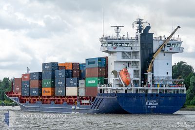
ELBSTAR
Container Ship
Current Trip
| Time Travelled | 17 h, 18 mins |
|---|---|
| Remaining Time | --- |
| Distance Travelled | 229.18 nm |
| Remaining Distance | --- |
| AVG Speed | 13.1 Knop |
| MAX Speed | 15.5 Knop |
| AVG Wind | 17.8 knots |
| MAX Wind | 23 knots |
| MIN Temp | 16.3°C / 61.34°F |
| MAX Temp | 20.6°C / 69.08°F |
| Djupgående | 7.5 m |
| Position mottagen | 1 m sen |
Current Position
| Longitud | 8.24396° |
|---|---|
| Latitude | 53.99538° |
| Status | Under way using engine |
| Fart | 13.9 Knop |
| Kurs | 93.6° |
| Område | North Sea |
| Station | T-AIS |
| Position mottagen | 1 m sen |
Info
Information
The current position of ELBSTAR is in North Sea with coordinates 53.99538° / 8.24396° as reported on 2024-09-01 05:02 by AIS to our vessel tracker app. The vessel's current speed is 13.9 Knop and is heading at the port of HELSINKI. The estimated time of arrival as calculated by MyShipTracking vessel tracking app is 2024-09-03 17:00 LT
The vessel ELBSTAR (IMO: 9387592, MMSI: 305978000) is a Container Ship that was built in 2009 ( 15 År gammal ). It's sailing under the flag of [AG] Antigua Barbuda.
In this page you can find informations about the vessels current position, last detected port calls, and current voyage information. If the vessels is not in coverage by AIS you will find the latest position.
The current position of ELBSTAR is detected by our AIS receivers and we are not responsible for the reliability of the data. The last position was recorded while the vessel was in Coverage by the Ais receivers of our vessel tracking app.
The current draught of ELBSTAR as reported by AIS is 7.5 meters
Weather
| Temperature | 16.6°C / 61.88°F |
|---|---|
| Wind Speed | 16 knots |
| Direction | 91° E |
| Pressure | 1022.6 hPa |
| Humidity | 70.9 % |
| Cloud Coverage | 3 % |
Featured Company
Last Port Calls
| Port | Arrival | Departure | Time In Port |
|---|---|---|---|
| 2024-08-30 07:03 | 2024-08-31 13:46 | 1 d | |
| 2024-08-30 05:31 | 2024-08-30 05:42 | 11 m | |
| 2024-08-30 05:18 | |||
| 2024-08-29 11:29 | |||
| 2024-08-28 20:05 | 2024-08-29 09:46 | 13 h | |
| 2024-08-28 15:49 | 2024-08-28 20:03 | 4 h | |
| 2024-08-26 14:54 | 2024-08-27 06:30 | 15 h | |
| 2024-08-26 01:01 | 2024-08-26 02:07 | 1 h | |
| 2024-08-21 07:16 | 2024-08-21 11:31 | 4 h | |
| 2024-08-20 20:20 | 2024-08-21 03:56 | 7 h |
Most Visited Ports (Last year)
| Port | Arrivals | |
|---|---|---|
| 27 | ||
| 20 | ||
| 18 | ||
| 17 | ||
| 16 | ||
| 16 |
Last Trips
| Origin | Departure | Destination | Arrival | Distance | |
|---|---|---|---|---|---|
| 2024-08-30 05:42 | 2024-08-30 07:03 | 15.48 nm | |||
| 2024-08-29 09:46 | 2024-08-30 05:31 | 16.57 nm | |||
| 2024-08-29 09:46 | 2024-08-30 05:18 | 16.35 nm | |||
| 2024-08-29 09:46 | 2024-08-29 11:29 | 16.22 nm | |||
| 2024-08-28 20:03 | 2024-08-28 20:05 | 1.20 nm | |||
| 2024-08-27 06:30 | 2024-08-28 15:49 | 325.86 nm | |||
| 2024-08-26 02:07 | 2024-08-26 14:54 | 89.13 nm | |||
| 2024-08-21 11:31 | 2024-08-26 01:01 | 1093.47 nm | |||
| 2024-08-21 03:56 | 2024-08-21 07:16 | 4.41 nm | |||
| 2024-08-19 12:27 | 2024-08-20 20:20 | 419.20 nm |
Events
| Tid | Event | Detaljer | Position / Dest | Information |
|---|---|---|---|---|
| 2024-09-01 04:06 | Status ändrad | Under way using engine Default |
53.96922 / 7.90654
FIHEL
|
Fart: 13.3 kn Kurs: 74° |
| 2024-09-01 04:05 | Status ändrad | Default Under way using engine |
53.96769 / 7.89754
FIHEL
|
Fart: 13 kn Kurs: 74° |
| 2024-09-01 03:38 | Status ändrad | Under way using engine Default |
53.94486 / 7.73816
FIHEL
|
Fart: 12.8 kn Kurs: 78° |
| 2024-09-01 03:37 | Status ändrad | Default Under way using engine |
53.94387 / 7.73038
FIHEL
|
Fart: 13 kn Kurs: 77.4° |
| 2024-09-01 00:50 | Status ändrad | Under way using engine Default |
53.81723 / 6.77859
FIHEL
|
Fart: 12.3 kn Kurs: 76° |
| 2024-09-01 00:49 | Status ändrad | Default Under way using engine |
53.81625 / 6.77211
FIHEL
|
Fart: 12.3 kn Kurs: 78.9° |
| 2024-09-01 00:47 | Status ändrad | Under way using engine Default |
53.81462 / 6.75976
FIHEL
|
Fart: 12.4 kn Kurs: 79° |
| 2024-09-01 00:37 | Status ändrad | Default Under way using engine |
53.80585 / 6.70335
FIHEL
|
Fart: 12.4 kn Kurs: 73.4° |
| 2024-09-01 00:34 | Status ändrad | Under way using engine Default |
53.80340 / 6.68945
FIHEL
|
Fart: 12.4 kn Kurs: 74° |
| 2024-09-01 00:33 | Status ändrad | Default Under way using engine |
53.80200 / 6.68203
FIHEL
|
Fart: 12.5 kn Kurs: 75.8° |