
DETECTOR
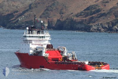
Anchor Handling Vessel
Current Trip
| Time Travelled | --- |
|---|---|
| Remaining Time | 4 h, 59 mins |
| Distance Travelled | --- |
| Remaining Distance | 65.65 nm |
| AVG Speed | --- |
| MAX Speed | --- |
| AVG Wind | --- |
| MAX Wind | --- |
| MIN Temp | --- |
| MAX Temp | --- |
| Djupgående | 6 m |
| Position mottagen | 6 h, 50 m sen |
Current Position
| Longitud | --- |
|---|---|
| Latitude | --- |
| Status | Restricted manoeuverability |
| Fart | 5.5 Knop |
| Kurs | 348.6° |
| Område | North Sea |
| Station | T-AIS |
| Position mottagen | 6 h, 50 m sen |
Info
Information
The current position of DETECTOR is in North Sea with coordinates 56.15716° / -1.28536° as reported on 2025-12-14 16:03 by AIS to our vessel tracker app. The vessel's current speed is 5.5 Knop and is heading at the port of ABERDEEN. The estimated time of arrival as calculated by MyShipTracking vessel tracking app is 2025-12-15 03:53 LT
The vessel DETECTOR (IMO: 9298911, MMSI: 219032869) is a Anchor Handling Vessel that was built in 2006 ( 19 År gammal ). It's sailing under the flag of [DK] Denmark.
In this page you can find informations about the vessels current position, last detected port calls, and current voyage information. If the vessels is not in coverage by AIS you will find the latest position.
The current position of DETECTOR is detected by our AIS receivers and we are not responsible for the reliability of the data. The last position was recorded while the vessel was in Coverage by the Ais receivers of our vessel tracking app.
The current draught of DETECTOR as reported by AIS is 6 meters
Weather
| Temperature | 11.2°C / 52.16°F |
|---|---|
| Wind Speed | 29 knots |
| Direction | 202° SSW |
| Pressure | 999.1 hPa |
| Humidity | 84.2 % |
| Cloud Coverage | 100 % |
Featured Company
Last Port Calls
Most Visited Ports (Last year)
| Port | Arrivals | |
|---|---|---|
| 15 | ||
| 4 | ||
| 3 | ||
| 3 | ||
| 2 | ||
| 2 |
Last Trips
| Origin | Departure | Destination | Arrival | Distance | |
|---|---|---|---|---|---|
| 2025-11-02 12:00 | 2025-11-04 08:35 | 336.13 nm | |||
| 2025-10-29 16:14 | 2025-11-02 10:07 | 390.39 nm | |||
| 2025-10-21 17:24 | 2025-10-22 06:01 | 101.23 nm | |||
| 2025-10-20 00:24 | 2025-10-20 12:51 | 102.17 nm | |||
| 2025-09-27 13:24 | 2025-10-02 09:59 | 243.31 nm |
Events
| Tid | Event | Detaljer | Position / Dest | Information |
|---|---|---|---|---|
| 2025-12-14 16:03 | UTANFÖR täckningsområde |
56.15716 / -1.28536
North Sea
ABERDEEN
|
Fart: 5.5 kn Kurs: 348.6° |
|
| 2025-12-14 08:18 | Destination ändrad | ABERDEEN DKTHYBORON |
55.54339 / -1.04789
ABERDEEN
|
Fart: 4.5 kn Kurs: 348° |
| 2025-12-14 08:18 | ETA ändrat | 2025/12/15 11:00 2025/11/28 07:00 |
55.54339 / -1.04789
ABERDEEN
|
Fart: 4.5 kn Kurs: 348° |
| 2025-12-14 08:05 | I täckningsområde |
55.52694 / -1.04197
North Sea
|
Fart: 4.5 kn Kurs: 339.1° |
|
| 2025-12-14 04:33 | UTANFÖR täckningsområde |
55.29940 / -.80706
North Sea
|
Fart: 4.8 kn Kurs: 342.3° |
|
| 2025-12-14 02:11 | Upptäckt i hav | United Kingdom part of the North Sea |
55.19706 / -.77242
North Sea
|
Fart: 2.5 kn Kurs: 297.2° |
| 2025-12-14 02:11 | I täckningsområde |
55.19706 / -.77242
North Sea
|
Fart: 2.5 kn Kurs: 297.2° |
|
| 2025-12-05 14:19 | UTANFÖR täckningsområde |
56.69521 / 8.22099
North Sea
[DK] THYBORON
|
Fart: Kurs: 281.3° |
|
| 2025-12-05 13:22 | I täckningsområde |
56.69523 / 8.22095
North Sea
[DK] THYBORON
|
Fart: Kurs: 282.3° |
|
| 2025-12-05 07:13 | UTANFÖR täckningsområde |
56.69521 / 8.22095
North Sea
[DK] THYBORON
|
Fart: Kurs: 236.7° |