
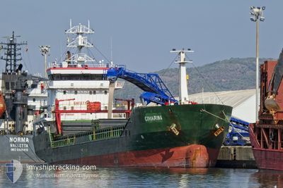
CIVARINA
General Cargo
Current Trip
Current Position
| Longitud | 29.09050° |
|---|---|
| Latitude | 41.18753° |
| Status | Under way using engine |
| Fart | 11.4 Knop |
| Kurs | 220° |
| Område | Sea of Marmara |
| Station | T-AIS |
| Position mottagen | Nu |
Info
Information
The current position of CIVARINA is in Sea of Marmara with coordinates 41.18753° / 29.09050° as reported on 2024-05-10 18:00 by AIS to our vessel tracker app. The vessel's current speed is 11.4 Knop and is currently inside the port of ISTANBUL.
The vessel CIVARINA (IMO: 9396440, MMSI: 377602000) is a General Cargo that was built in 2008 ( 16 År gammal ). It's sailing under the flag of [VC] St Vincent Grenadines.
In this page you can find informations about the vessels current position, last detected port calls, and current voyage information. If the vessels is not in coverage by AIS you will find the latest position.
The current position of CIVARINA is detected by our AIS receivers and we are not responsible for the reliability of the data. The last position was recorded while the vessel was in Coverage by the Ais receivers of our vessel tracking app.
The current draught of CIVARINA as reported by AIS is 6 meters
Weather
| Temperature | 14°C / 57.2°F |
|---|---|
| Wind Speed | 19 knots |
| Direction | 37° NE |
| Pressure | 1012.6 hPa |
| Humidity | 79.1 % |
| Cloud Coverage | 100 % |
Featured Company
Last Port Calls
| Port | Arrival | Departure | Time In Port |
|---|---|---|---|
| 2024-05-10 20:53 | |||
| 2024-05-07 23:42 | 2024-05-09 17:10 | 1 d | |
| 2024-04-29 11:18 | 2024-05-01 15:17 | 2 d | |
| 2024-04-20 04:38 | 2024-04-21 21:20 | 1 d | |
| 2024-04-16 23:20 | |||
| 2024-04-08 06:37 | 2024-04-10 21:54 | 2 d | |
| 2024-04-02 09:53 | 2024-04-04 02:10 | 1 d | |
| 2024-03-27 20:39 | |||
| 2024-03-19 09:24 | 2024-03-21 09:16 | 1 d | |
| 2024-03-11 07:00 | 2024-03-13 11:33 | 2 d |
Last Trips
| Origin | Departure | Destination | Arrival | Distance | |
|---|---|---|---|---|---|
| 2024-05-09 17:10 | 2024-05-10 20:53 | 178.87 nm | |||
| 2024-05-01 15:17 | 2024-05-07 23:42 | 1384.49 nm | |||
| 2024-04-21 21:20 | 2024-04-29 11:18 | 1018.06 nm | |||
| 2024-04-10 21:54 | 2024-04-16 23:20 | 1218.68 nm | |||
| 2024-04-04 02:10 | 2024-04-08 06:37 | 276.26 nm | |||
| 2024-03-27 20:39 | 2024-04-02 09:53 | 766.71 nm | |||
| 2024-03-13 11:33 | 2024-03-19 09:24 | 704.50 nm | |||
| 2024-03-01 13:09 | 2024-03-11 07:00 | 1320.05 nm |
Events
| Tid | Event | Detaljer | Position / Dest | Information |
|---|---|---|---|---|
| 2024-05-10 17:53 | ANLÄNDER HAMN |
|
41.20290 / 29.10850
[TR] ISTANBUL
|
Fart: 10.9 kn Kurs: 216° |
| 2024-05-10 17:44 | Byter havsområde | Turkish part of the Sea of Marmara Turkish part of the Black Sea |
41.22737 / 29.12650
Sea of Marmara
|
Fart: 9.7 kn Kurs: 195° |
| 2024-05-10 16:51 | STARTAR förflyttning | 3.09 nm, North West of RUMELI FENERI |
41.27178 / 29.07100
TRIST
|
Fart: 3.2 kn Kurs: 48° |
| 2024-05-10 16:29 | Status ändrad | Under way using engine At anchor |
41.26802 / 29.06820
TRIST
|
Fart: 0.2 kn Kurs: 6° |
| 2024-05-10 09:23 | Status ändrad | At anchor Under way using engine |
41.26823 / 29.07037
TRIST
|
Fart: 0.1 kn Kurs: 342° |
| 2024-05-10 09:18 | STOPPAR förflyttning | 2.95 nm, North West of RUMELI FENERI |
41.26837 / 29.07018
TRIST
|
Fart: 0.1 kn Kurs: 347° |
| 2024-05-10 07:34 | Byter havsområde | Turkish part of the Black Sea Romanian part of the Black Sea |
41.48917 / 29.08155
Black Sea
TRIST
|
Fart: 9 kn Kurs: 177° |
| 2024-05-10 07:34 | Status ändrad | Under way using engine Default |
41.48917 / 29.08155
TRIST
|
Fart: 9.1 kn Kurs: 177° |
| 2024-05-10 07:34 | I täckningsområde |
41.48917 / 29.08155
Black Sea
TRIST
|
Fart: 9 kn Kurs: 177° |
|
| 2024-05-09 14:26 | UTANFÖR täckningsområde |
44.05832 / 28.72280
Black Sea
TRIST
|
Fart: 9 kn Kurs: 159° |