
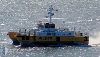
CETUS (PILOTS)
Pilot Ship
Current Trip
| Trip Time | 1 day |
|---|---|
| Trip Distance | 264.33 nm |
| AVG Speed | 10.3 Knop |
| MAX Speed | 10.3 Knop |
| Djupgående | 3 m |
| AVG Wind | 9.3 knots |
| MAX Wind | 12.9 knots |
| MIN Temp | 13.1°C / 55.58°F |
| MAX Temp | 18°C / 64.4°F |
| Position mottagen | 1 m sen |
Current Position
| Longitud | 3.59859° |
|---|---|
| Latitude | 51.44349° |
| Status | Moored |
| Fart | |
| Kurs | 296° |
| Område | North Sea |
| Station | T-AIS |
| Position mottagen | 1 m sen |
Info
Information
The current position of CETUS (PILOTS) is in North Sea with coordinates 51.44349° / 3.59859° as reported on 2024-05-14 01:39 by AIS to our vessel tracker app. The vessel's current speed is 0 Knop and is currently inside the port of VLISSINGEN STATION.
The vessel CETUS (PILOTS) (IMO: 9367102, MMSI: 246380000) is a Pilot Ship that was built in 2005 ( 19 År gammal ). It's sailing under the flag of [NL] Netherlands.
In this page you can find informations about the vessels current position, last detected port calls, and current voyage information. If the vessels is not in coverage by AIS you will find the latest position.
The current position of CETUS (PILOTS) is detected by our AIS receivers and we are not responsible for the reliability of the data. The last position was recorded while the vessel was in Coverage by the Ais receivers of our vessel tracking app.
The current draught of CETUS (PILOTS) as reported by AIS is 3 meters
Weather
| Temperature | 14.8°C / 58.64°F |
|---|---|
| Wind Speed | 8 knots |
| Direction | 129° SE |
| Pressure | 1004.5 hPa |
| Humidity | 88.6 % |
| Cloud Coverage | 5 % |
Featured Company
Last Port Calls
| Port | Arrival | Departure | Time In Port |
|---|---|---|---|
| 2024-05-13 19:57 | |||
| 2024-05-12 05:30 | 2024-05-12 08:08 | 2 h | |
| 2024-05-10 03:49 | 2024-05-10 05:15 | 1 h | |
| 2024-05-03 15:24 | 2024-05-09 07:13 | 5 d | |
| 2024-05-02 03:07 | 2024-05-03 11:33 | 1 d | |
| 2024-04-29 03:07 | 2024-04-29 08:04 | 4 h | |
| 2024-04-25 03:11 | 2024-04-25 16:20 | 13 h | |
| 2024-04-24 04:30 | 2024-04-24 04:50 | 19 m | |
| 2024-04-22 03:49 | 2024-04-22 04:52 | 1 h | |
| 2024-04-21 11:20 | 2024-04-21 15:29 | 4 h |
Most Visited Ports (Last year)
| Port | Arrivals | |
|---|---|---|
| 188 |
Last Trips
| Origin | Departure | Destination | Arrival | Distance | |
|---|---|---|---|---|---|
| 2024-05-12 10:08 | 2024-05-13 21:57 | 264.33 nm | |||
| 2024-05-10 07:15 | 2024-05-12 07:30 | 342.90 nm | |||
| 2024-05-09 09:13 | 2024-05-10 05:49 | 168.57 nm | |||
| 2024-05-03 13:33 | 2024-05-03 17:24 | 54.57 nm | |||
| 2024-04-29 10:04 | 2024-05-02 05:07 | 460.52 nm | |||
| 2024-04-25 18:20 | 2024-04-29 05:07 | 570.34 nm | |||
| 2024-04-24 06:50 | 2024-04-25 05:11 | 191.65 nm | |||
| 2024-04-22 06:52 | 2024-04-24 06:30 | 340.75 nm | |||
| 2024-04-21 17:29 | 2024-04-22 05:49 | 114.84 nm | |||
| 2024-04-20 21:54 | 2024-04-21 13:20 | 105.16 nm |
Events
| Tid | Event | Detaljer | Position / Dest | Information |
|---|---|---|---|---|
| 2024-05-13 20:01 | Status ändrad | Moored Under way using engine |
51.44349 / 3.59859
[NL] VLISSINGEN STATION
|
Fart: Kurs: 295° |
| 2024-05-13 19:58 | STOPPAR förflyttning |
51.44351 / 3.59858
[NL] VLISSINGEN STATION
|
Fart: 0.1 kn Kurs: 286° |
|
| 2024-05-13 19:57 | ANLÄNDER HAMN |
|
51.44351 / 3.59858
[NL] VLISSINGEN STATION
|
Fart: 0.6 kn Kurs: 289° |
| 2024-05-13 15:27 | STARTAR förflyttning | 17.06 nm, West of NEELTJE JANS |
51.73597 / 3.28251
PILOT BOARDING AREA
|
Fart: 8.7 kn Kurs: 6.6° |
| 2024-05-13 15:23 | STOPPAR förflyttning | 17.08 nm, West of NEELTJE JANS |
51.73429 / 3.28083
PILOT BOARDING AREA
|
Fart: 0.2 kn Kurs: 63° |
| 2024-05-13 15:08 | STARTAR förflyttning | 17.45 nm, North West of JACOBAHAVEN |
51.72197 / 3.26341
PILOT BOARDING AREA
|
Fart: 5.7 kn Kurs: 161.4° |
| 2024-05-13 15:03 | STOPPAR förflyttning | 17.54 nm, West of NEELTJE JANS |
51.72357 / 3.26172
PILOT BOARDING AREA
|
Fart: 0.3 kn Kurs: 131° |
| 2024-05-13 14:47 | STARTAR förflyttning | 16.89 nm, West of NEELTJE JANS |
51.71960 / 3.27791
PILOT BOARDING AREA
|
Fart: 12.6 kn Kurs: 25° |
| 2024-05-13 14:37 | STOPPAR förflyttning | 16.89 nm, North West of JACOBAHAVEN |
51.71788 / 3.27660
PILOT BOARDING AREA
|
Fart: 0.3 kn Kurs: 12° |
| 2024-05-13 12:56 | STARTAR förflyttning | 18.5 nm, North West of OOSTWATERING |
51.71373 / 3.22260
PILOT BOARDING AREA
|
Fart: 3.6 kn Kurs: 15° |