
C.EPSILON
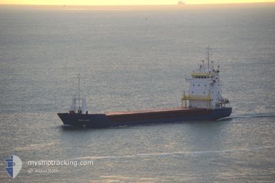
General Cargo
Current Trip
| Time Travelled | 4 days |
|---|---|
| Remaining Time | 15 h, 30 mins |
| Distance Travelled | 1143.48 nm |
| Remaining Distance | 222.21 nm |
| AVG Speed | 9.3 Knop |
| MAX Speed | 13 Knop |
| AVG Wind | 17.6 knots |
| MAX Wind | 24.5 knots |
| MIN Temp | 13.5°C / 56.3°F |
| MAX Temp | 19.1°C / 66.38°F |
| Djupgående | 4 m |
| Position mottagen | 18 h, 14 m sen |
Current Position
| Longitud | --- |
|---|---|
| Latitude | --- |
| Status | Under way using engine |
| Fart | 10.2 Knop |
| Kurs | 85° |
| Område | Mediterranean Sea - Eastern Basin |
| Station | T-AIS |
| Position mottagen | 18 h, 14 m sen |
Info
Information
The current position of C.EPSILON is in Mediterranean Sea - Eastern Basin with coordinates 36.09100° / 29.70308° as reported on 2025-12-10 23:41 by AIS to our vessel tracker app. The vessel's current speed is 10.2 Knop and is heading at the port of ISKENDERUN. The estimated time of arrival as calculated by MyShipTracking vessel tracking app is 2025-12-12 12:25 LT
The vessel C.EPSILON (IMO: 9130212, MMSI: 314470000) is a General Cargo that was built in 1997 ( 28 År gammal ). It's sailing under the flag of [BB] Barbados.
In this page you can find informations about the vessels current position, last detected port calls, and current voyage information. If the vessels is not in coverage by AIS you will find the latest position.
The current position of C.EPSILON is detected by our AIS receivers and we are not responsible for the reliability of the data. The last position was recorded while the vessel was in Coverage by the Ais receivers of our vessel tracking app.
The current draught of C.EPSILON as reported by AIS is 4 meters
Weather
| Temperature | 17.1°C / 62.78°F |
|---|---|
| Wind Speed | 17 knots |
| Direction | 46° NE |
| Pressure | 1014.4 hPa |
| Humidity | 51 % |
| Cloud Coverage | 5 % |
Featured Company
Last Port Calls
| Port | Arrival | Departure | Time In Port |
|---|---|---|---|
| 2025-12-04 21:21 | 2025-12-06 21:25 | 2 d | |
| 2025-10-28 21:02 | 2025-10-31 02:54 | 2 d | |
| 2025-10-23 09:24 | 2025-10-26 15:31 | 3 d | |
| 2025-10-20 18:28 | 2025-10-21 13:32 | 19 h | |
| 2025-10-15 18:27 | 2025-10-17 18:56 | 2 d | |
| 2025-10-07 20:44 | 2025-10-10 13:08 | 2 d |
Most Visited Ports (Last year)
| Port | Arrivals | |
|---|---|---|
| 3 | ||
| 3 | ||
| 2 | ||
| 2 | ||
| 2 | ||
| 2 |
Last Trips
| Origin | Departure | Destination | Arrival | Distance | |
|---|---|---|---|---|---|
| 2025-10-31 02:54 | 2025-12-04 21:21 | 5453.33 nm | |||
| 2025-10-26 15:31 | 2025-10-28 21:02 | 43.96 nm | |||
| 2025-10-21 13:32 | 2025-10-23 09:24 | 256.87 nm | |||
| 2025-10-17 18:56 | 2025-10-20 18:28 | 664.05 nm | |||
| 2025-10-10 13:08 | 2025-10-15 18:27 | 592.89 nm | |||
| 2025-09-25 07:16 | 2025-10-07 20:44 | 1705.21 nm |
Events
| Tid | Event | Detaljer | Position / Dest | Information |
|---|---|---|---|---|
| 2025-12-11 00:01 | Status ändrad | Default Under way using engine |
36.09298 / 29.77467
TRISK
|
Fart: 10.2 kn Kurs: 85° |
| 2025-12-10 23:41 | UTANFÖR täckningsområde |
36.09100 / 29.70308
Mediterranean Sea - Eastern Basin
TRISK
|
Fart: 10.2 kn Kurs: 85° |
|
| 2025-12-10 23:17 | Byter havsområde | Turkish part of the Mediterranean Sea - Eastern Basin Greek part of the Mediterranean Sea - Eastern Basin |
36.08927 / 29.62113
Mediterranean Sea - Eastern Basin
TRISK
|
Fart: 9.6 kn Kurs: 92.4° |
| 2025-12-10 23:08 | ETA ändrat | 2025/12/12 10:30 2025/12/12 02:00 |
36.09115 / 29.58927
TRISK
|
Fart: 9.9 kn Kurs: 110.4° |
| 2025-12-10 23:05 | Byter havsområde | Greek part of the Mediterranean Sea - Eastern Basin Greek part of the Aegean Sea |
36.09317 / 29.58118
Mediterranean Sea - Eastern Basin
TRISK
|
Fart: 9.8 kn Kurs: 107.2° |
| 2025-12-10 23:03 | I täckningsområde |
36.09317 / 29.58118
Mediterranean Sea - Eastern Basin
TRISK
|
Fart: 9.8 kn Kurs: 107.2° |
|
| 2025-12-10 12:07 | Status ändrad | Default Under way using engine |
36.33780 / 27.48268
TRISK
|
Fart: 9.8 kn Kurs: 87° |
| 2025-12-10 11:55 | UTANFÖR täckningsområde |
36.33233 / 27.44072
Aegean Sea
TRISK
|
Fart: 9.8 kn Kurs: 87° |
|
| 2025-12-10 11:22 | Status ändrad | Under way using engine Default |
36.31992 / 27.33398
TRISK
|
Fart: 9.8 kn Kurs: 80° |
| 2025-12-10 11:13 | Status ändrad | Default Under way using engine |
36.31522 / 27.30373
TRISK
|
Fart: 10 kn Kurs: 70.8° |