
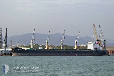
CARIBOO
Cargo
Current Trip
KEMBLA AU
| Time Travelled | 40 days |
|---|---|
| Remaining Time | --- |
| Distance Travelled | 5411.07 nm |
| Remaining Distance | --- |
| AVG Speed | 10.3 Knop |
| MAX Speed | 14.2 Knop |
| AVG Wind | 10.9 knots |
| MAX Wind | 22 knots |
| MIN Temp | 26.4°C / 79.52°F |
| MAX Temp | 31.9°C / 89.42°F |
| Djupgående | 10.2 m |
| Position mottagen | 7 d sen |
Current Position
| Longitud | 104.30540° |
|---|---|
| Latitude | 1.27227° |
| Status | Under way using engine |
| Fart | 12.7 Knop |
| Kurs | 81° |
| Område | Singapore Strait |
| Station | T-AIS |
| Position mottagen | 7 d sen |
Info
Information
The current position of CARIBOO is in Singapore Strait with coordinates 1.27227° / 104.30540° as reported on 2024-05-07 05:28 by AIS to our vessel tracker app. The vessel's current speed is 12.7 Knop
The vessel CARIBOO (IMO: 9524695, MMSI: 538004800) is a Cargo It's sailing under the flag of [MH] Marshall Is.
In this page you can find informations about the vessels current position, last detected port calls, and current voyage information. If the vessels is not in coverage by AIS you will find the latest position.
The current position of CARIBOO is detected by our AIS receivers and we are not responsible for the reliability of the data. The last position was recorded while the vessel was in Coverage by the Ais receivers of our vessel tracking app.
The current draught of CARIBOO as reported by AIS is 10.2 meters
Weather
| Temperature | 27.1°C / 80.78°F |
|---|---|
| Wind Speed | 16 knots |
| Direction | 119° ESE |
| Pressure | 1011.6 hPa |
| Humidity | 83 % |
| Cloud Coverage | 100 % |
Featured Company
Events
| Tid | Event | Detaljer | Position / Dest | Information |
|---|---|---|---|---|
| 2024-05-07 05:37 | Status ändrad | Default Under way using engine |
1.28245 / 104.33296
KEMBLA AU
|
Fart: 12.7 kn Kurs: 81° |
| 2024-05-07 05:28 | UTANFÖR täckningsområde |
1.27227 / 104.30540
Singapore Strait
KEMBLA AU
|
Fart: 12.7 kn Kurs: 81° |
|
| 2024-05-07 04:58 | Byter havsområde | Malaysian part of the Singapore Strait Indonesian part of the Singapore Strait |
1.25730 / 104.20277
Singapore Strait
KEMBLA AU
|
Fart: 12.6 kn Kurs: 83.6° |
| 2024-05-07 03:49 | Byter havsområde | Indonesian part of the Singapore Strait Singaporean part of the Singapore Strait |
1.24792 / 103.99251
Singapore Strait
KEMBLA AU
|
Fart: 7.6 kn Kurs: 115.1° |
| 2024-05-07 03:15 | STARTAR förflyttning | 4.57 nm, West of TANAH MERAH |
1.28343 / 103.94744
KEMBLA AU
|
Fart: 3.6 kn Kurs: 147° |
| 2024-05-07 02:51 | Destination ändrad | KEMBLA AU SINGAPORE |
1.28528 / 103.94654
KEMBLA AU
|
Fart: 0.1 kn Kurs: 62° |
| 2024-05-07 02:51 | ETA ändrat | 2024/05/21 01:00 2024/05/06 13:45 |
1.28528 / 103.94654
KEMBLA AU
|
Fart: 0.1 kn Kurs: 62° |
| 2024-05-07 02:48 | Status ändrad | Under way using engine At anchor |
1.28528 / 103.94657
SINGAPORE
|
Fart: Kurs: 61° |
| 2024-05-07 00:52 | Djupgående ändrat | 10.2 10.1 |
1.28539 / 103.94634
SINGAPORE
|
Fart: Kurs: 89° |
| 2024-05-06 14:50 | STOPPAR förflyttning | 4.57 nm, West of TANAH MERAH |
1.28515 / 103.94679
SINGAPORE
|
Fart: 0.3 kn Kurs: 45° |