
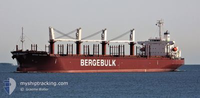
BERGE HALLASAN
Cargo
Current Trip
| Time Travelled | 3 days |
|---|---|
| Remaining Time | --- |
| Distance Travelled | 889.37 nm |
| Remaining Distance | --- |
| AVG Speed | 10.8 Knop |
| MAX Speed | 12.7 Knop |
| AVG Wind | 7.5 knots |
| MAX Wind | 17.3 knots |
| MIN Temp | 26.2°C / 79.16°F |
| MAX Temp | 31°C / 87.8°F |
| Djupgående | 9.2 m |
| Position mottagen | 1 d sen |
Current Position
| Longitud | 57.27875° |
|---|---|
| Latitude | 24.86643° |
| Status | Under way using engine |
| Fart | 11.9 Knop |
| Kurs | 118.1° |
| Område | Gulf of Oman |
| Station | T-AIS |
| Position mottagen | 1 d sen |
Info
Information
The current position of BERGE HALLASAN is in Gulf of Oman with coordinates 24.86643° / 57.27875° as reported on 2024-05-15 07:57 by AIS to our vessel tracker app. The vessel's current speed is 11.9 Knop and is heading at the port of PORT LINCOLN. The estimated time of arrival as calculated by MyShipTracking vessel tracking app is 2024-06-06 00:30 LT
The vessel BERGE HALLASAN (IMO: 9755749, MMSI: 374922000) is a Cargo It's sailing under the flag of [PA] Panama.
In this page you can find informations about the vessels current position, last detected port calls, and current voyage information. If the vessels is not in coverage by AIS you will find the latest position.
The current position of BERGE HALLASAN is detected by our AIS receivers and we are not responsible for the reliability of the data. The last position was recorded while the vessel was in Coverage by the Ais receivers of our vessel tracking app.
The current draught of BERGE HALLASAN as reported by AIS is 9.2 meters
Weather
| Temperature | 28.4°C / 83.12°F |
|---|---|
| Wind Speed | 5 knots |
| Direction | 257° WSW |
| Pressure | 1011.2 hPa |
| Humidity | 71.6 % |
| Cloud Coverage | --- |
Featured Company
Last Port Calls
| Port | Arrival | Departure | Time In Port |
|---|---|---|---|
| 2024-04-28 18:30 | 2024-05-13 01:19 | 14 d | |
| 2024-04-25 04:33 | 2024-04-25 15:19 | 10 h | |
| 2024-04-22 02:25 | 2024-04-23 16:00 | 1 d | |
| 2024-04-15 12:02 | |||
| 2024-03-28 22:28 | |||
| 2024-03-11 22:53 | 2024-03-22 09:04 | 10 d | |
| 2024-03-10 06:24 |
Last Trips
Events
| Tid | Event | Detaljer | Position / Dest | Information |
|---|---|---|---|---|
| 2024-05-15 08:05 | Status ändrad | Default Under way using engine |
24.85416 / 57.30463
AU PLO
|
Fart: 11.9 kn Kurs: 118.1° |
| 2024-05-15 08:01 | ETA ändrat | 2024/06/06 00:30 2024/06/06 20:00 |
24.86643 / 57.27875
AU PLO
|
Fart: 11.9 kn Kurs: 118.1° |
| 2024-05-15 07:57 | UTANFÖR täckningsområde |
24.86643 / 57.27875
Gulf of Oman
AU PLO
|
Fart: 11.9 kn Kurs: 118.1° |
|
| 2024-05-15 05:50 | Byter havsområde | Omani part of the Gulf of Oman United Arab Emirates part of the Gulf of Oman |
25.06040 / 56.87910
Gulf of Oman
AU PLO
|
Fart: 11.6 kn Kurs: 118.7° |
| 2024-05-15 03:49 | STARTAR förflyttning | 10.71 nm, East of FUJAIRAH |
25.20076 / 56.55266
AU PLO
|
Fart: 3.1 kn Kurs: 118° |
| 2024-05-15 03:27 | Destination ändrad | AU PLO AE FUJ |
25.20465 / 56.54992
AU PLO
|
Fart: 0.5 kn Kurs: 182° |
| 2024-05-15 03:22 | Djupgående ändrat | 9.2 8.9 |
25.20502 / 56.54999
AE FUJ
|
Fart: 0.1 kn Kurs: 183° |
| 2024-05-15 03:22 | ETA ändrat | 2024/06/06 20:00 2024/05/14 19:30 |
25.20502 / 56.54999
AE FUJ
|
Fart: 0.1 kn Kurs: 183° |
| 2024-05-15 03:21 | Status ändrad | Under way using engine Default |
25.20504 / 56.55001
AE FUJ
|
Fart: 0.1 kn Kurs: 185° |
| 2024-05-15 03:18 | Status ändrad | Default At anchor |
25.20506 / 56.55006
AE FUJ
|
Fart: 0.1 kn Kurs: 188° |