
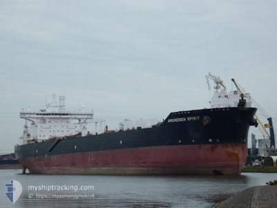
AMUNDSEN SPIRIT
Oil Products Tanker
Current Trip
CATCHER OF
| Time Travelled | 19 days |
|---|---|
| Remaining Time | --- |
| Distance Travelled | 1877.85 nm |
| Remaining Distance | --- |
| AVG Speed | 11.8 Knop |
| MAX Speed | 15.7 Knop |
| AVG Wind | 12.7 knots |
| MAX Wind | 25 knots |
| MIN Temp | 6.6°C / 43.88°F |
| MAX Temp | 15.7°C / 60.26°F |
| Djupgående | 9.2 m |
| Position mottagen | 1 h, 16 m sen |
Current Position
| Longitud | -2.50365° |
|---|---|
| Latitude | 57.69473° |
| Status | At anchor |
| Fart | |
| Kurs | 75° |
| Område | North Sea |
| Station | T-AIS |
| Position mottagen | 1 h, 16 m sen |
Info
Information
The current position of AMUNDSEN SPIRIT is in North Sea with coordinates 57.69473° / -2.50365° as reported on 2024-05-21 14:25 by AIS to our vessel tracker app. The vessel's current speed is 0 Knop
The vessel AMUNDSEN SPIRIT (IMO: 9438858, MMSI: 311027700) is a Oil Products Tanker that was built in 2010 ( 14 År gammal ). It's sailing under the flag of [BS] Bahamas.
In this page you can find informations about the vessels current position, last detected port calls, and current voyage information. If the vessels is not in coverage by AIS you will find the latest position.
The current position of AMUNDSEN SPIRIT is detected by our AIS receivers and we are not responsible for the reliability of the data. The last position was recorded while the vessel was in Coverage by the Ais receivers of our vessel tracking app.
The current draught of AMUNDSEN SPIRIT as reported by AIS is 9.2 meters
Weather
| Temperature | 14.4°C / 57.92°F |
|---|---|
| Wind Speed | 14 knots |
| Direction | 117° ESE |
| Pressure | 1012.1 hPa |
| Humidity | 84.8 % |
| Cloud Coverage | 71 % |
Featured Company
Last Port Calls
| Port | Arrival | Departure | Time In Port |
|---|---|---|---|
| 2024-04-30 17:16 | 2024-05-01 23:01 | 1 d | |
| 2024-04-26 00:17 | 2024-04-26 23:32 | 23 h | |
| 2024-04-21 13:13 | 2024-04-22 15:56 | 1 d | |
| 2024-04-11 06:45 | 2024-04-12 19:28 | 1 d | |
| 2024-03-24 22:48 | 2024-03-25 22:44 | 23 h |
Most Visited Ports (Last year)
| Port | Arrivals | |
|---|---|---|
| 7 | ||
| 3 | ||
| 2 | ||
| 2 | ||
| 1 | ||
| 1 |
Last Trips
| Origin | Departure | Destination | Arrival | Distance | |
|---|---|---|---|---|---|
| 2024-04-27 01:32 | 2024-04-30 19:16 | 941.09 nm | |||
| 2024-04-22 17:56 | 2024-04-26 02:17 | 604.61 nm | |||
| 2024-04-12 20:28 | 2024-04-21 15:13 | 1635.57 nm | |||
| 2024-03-25 22:44 | 2024-04-11 07:45 | 2058.54 nm | |||
| 2024-02-29 23:49 | 2024-03-24 22:48 | 1425.06 nm |
Events
| Tid | Event | Detaljer | Position / Dest | Information |
|---|---|---|---|---|
| 2024-05-21 14:28 | Status ändrad | Default At anchor |
57.69478 / -2.50356
CATCHER OF
|
Fart: Kurs: 75° |
| 2024-05-21 14:25 | Status ändrad | At anchor Default |
57.69473 / -2.50365
CATCHER OF
|
Fart: Kurs: 76° |
| 2024-05-21 14:25 | UTANFÖR täckningsområde |
57.69473 / -2.50365
North Sea
CATCHER OF
|
Fart: Kurs: 123.8° |
|
| 2024-05-21 14:16 | Status ändrad | Default At anchor |
57.69483 / -2.50368
CATCHER OF
|
Fart: Kurs: 77° |
| 2024-05-21 13:55 | Status ändrad | At anchor Default |
57.69462 / -2.50360
CATCHER OF
|
Fart: Kurs: -1° |
| 2024-05-21 13:40 | Status ändrad | Default At anchor |
57.69466 / -2.50352
CATCHER OF
|
Fart: Kurs: 70° |
| 2024-05-21 13:37 | Status ändrad | At anchor Default |
57.69463 / -2.50350
CATCHER OF
|
Fart: Kurs: 71° |
| 2024-05-21 13:13 | Status ändrad | Default At anchor |
57.69333 / -2.50333
CATCHER OF
|
Fart: Kurs: 73° |
| 2024-05-21 13:07 | Status ändrad | At anchor Default |
57.69468 / -2.50360
CATCHER OF
|
Fart: Kurs: 76° |
| 2024-05-21 12:16 | Status ändrad | Default At anchor |
57.69489 / -2.50360
CATCHER OF
|
Fart: Kurs: 80° |