
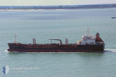
AMMOLIT
Oil/Chemical Tanker
Current Trip
RU PKC
| Time Travelled | 3 days |
|---|---|
| Remaining Time | --- |
| Distance Travelled | 286.75 nm |
| Remaining Distance | --- |
| AVG Speed | 12.6 Knop |
| MAX Speed | 14.2 Knop |
| AVG Wind | 6.7 knots |
| MAX Wind | 19 knots |
| MIN Temp | 5.6°C / 42.08°F |
| MAX Temp | 12.5°C / 54.5°F |
| Djupgående | 6.8 m |
| Position mottagen | 13 h, 3 m sen |
Current Position
| Longitud | 133.81943° |
|---|---|
| Latitude | 42.73010° |
| Status | Under way using engine |
| Fart | 13.7 Knop |
| Kurs | 52.3° |
| Område | Japan Sea |
| Station | T-AIS |
| Position mottagen | 13 h, 3 m sen |
Info
Information
The current position of AMMOLIT is in Japan Sea with coordinates 42.73010° / 133.81943° as reported on 2024-04-27 16:54 by AIS to our vessel tracker app. The vessel's current speed is 13.7 Knop
The vessel AMMOLIT (IMO: 9016870, MMSI: 273213390) is a Oil/Chemical Tanker that was built in 1995 ( 29 År gammal ). It's sailing under the flag of [RU] Russia.
In this page you can find informations about the vessels current position, last detected port calls, and current voyage information. If the vessels is not in coverage by AIS you will find the latest position.
The current position of AMMOLIT is detected by our AIS receivers and we are not responsible for the reliability of the data. The last position was recorded while the vessel was in Coverage by the Ais receivers of our vessel tracking app.
The current draught of AMMOLIT as reported by AIS is 6.8 meters
Weather
| Temperature | 6.8°C / 44.24°F |
|---|---|
| Wind Speed | 16 knots |
| Direction | 203° SSW |
| Pressure | 1013.1 hPa |
| Humidity | 78.4 % |
| Cloud Coverage | 100 % |
Featured Company
Last Port Calls
Most Visited Ports (Last year)
| Port | Arrivals | |
|---|---|---|
| 14 | ||
| 5 | ||
| 2 | ||
| 1 |
Last Trips
| Origin | Departure | Destination | Arrival | Distance | |
|---|---|---|---|---|---|
| 2024-04-22 17:24 | 2024-04-24 09:59 | 110.79 nm | |||
| 2024-03-31 18:42 | 2024-04-22 00:20 | 4325.05 nm | |||
| 2024-02-17 16:14 | 2024-03-29 15:36 | 4629.20 nm | |||
| 2024-02-15 16:29 | 2024-02-16 21:18 | 5.10 nm | |||
| 2023-12-19 14:40 | 2024-02-06 07:45 | 2388.11 nm |
Events
| Tid | Event | Detaljer | Position / Dest | Information |
|---|---|---|---|---|
| 2024-04-28 04:31 | STARTAR förflyttning | 15.66 nm, East of RUDNAYA PRISTAN |
44.37833 / 136.20500
RU PKC
|
Fart: 9 kn Kurs: 44° |
| 2024-04-28 03:37 | STOPPAR förflyttning | 15.14 nm, East of RUDNAYA PRISTAN |
44.36666 / 136.19333
RU PKC
|
Fart: Kurs: -1° |
| 2024-04-27 17:07 | Status ändrad | Default Under way using engine |
42.76167 / 133.87334
RU PKC
|
Fart: 13.7 kn Kurs: 52.3° |
| 2024-04-27 16:54 | UTANFÖR täckningsområde |
42.73010 / 133.81943
Japan Sea
|
Fart: 13.7 kn Kurs: 52.3° |
|
| 2024-04-27 08:05 | STARTAR förflyttning | 2.41 nm, North West of ISLYAMOVA |
43.07601 / 131.78564
RU PKC
|
Fart: 4.1 kn Kurs: 342° |
| 2024-04-27 08:01 | Djupgående ändrat | 6.8 6.4 |
43.07325 / 131.78443
RU PKC
|
Fart: 0.5 kn Kurs: 45° |
| 2024-04-27 08:01 | ETA ändrat | 2024/04/01 18:00 2024/04/25 14:00 |
43.07325 / 131.78443
RU PKC
|
Fart: 0.5 kn Kurs: 45° |
| 2024-04-27 07:54 | Status ändrad | Under way using engine At anchor |
43.07236 / 131.78375
RU PKC
|
Fart: Kurs: 41° |
| 2024-04-27 07:53 | Destination ändrad | RU PKC RU NJK |
43.07232 / 131.78376
RU PKC
|
Fart: Kurs: 41° |
| 2024-04-26 12:17 | Status ändrad | At anchor Default |
43.07276 / 131.78560
RU NJK
|
Fart: Kurs: -1° |