
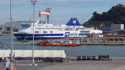
AF MIA
Ro-Ro/Passenger Ship
Current Trip
| Trip Time | 16 h, 6 mins |
|---|---|
| Trip Distance | 306.58 nm |
| AVG Speed | 17.4 Knop |
| MAX Speed | 20 Knop |
| Djupgående | 6.8 m |
| AVG Wind | 6.7 knots |
| MAX Wind | 14 knots |
| MIN Temp | 17.4°C / 63.32°F |
| MAX Temp | 19.1°C / 66.38°F |
| Position mottagen | 3 m sen |
Current Position
| Longitud | 19.45465° |
|---|---|
| Latitude | 41.31282° |
| Status | Moored |
| Fart | |
| Kurs | 202° |
| Område | Adriatic Sea |
| Station | T-AIS |
| Position mottagen | 3 m sen |
Info
Information
The current position of AF MIA is in Adriatic Sea with coordinates 41.31282° / 19.45465° as reported on 2024-05-12 09:01 by AIS to our vessel tracker app. The vessel's current speed is 0 Knop and is currently inside the port of DURRES.
The vessel AF MIA (IMO: 9144811, MMSI: 247343200) is a Ro-Ro/Passenger Ship that was built in 1997 ( 27 År gammal ). It's sailing under the flag of [IT] Italy.
In this page you can find informations about the vessels current position, last detected port calls, and current voyage information. If the vessels is not in coverage by AIS you will find the latest position.
The current position of AF MIA is detected by our AIS receivers and we are not responsible for the reliability of the data. The last position was recorded while the vessel was in Coverage by the Ais receivers of our vessel tracking app.
The current draught of AF MIA as reported by AIS is 6.8 meters
Weather
| Temperature | 19.5°C / 67.1°F |
|---|---|
| Wind Speed | 2 knots |
| Direction | 287° WNW |
| Pressure | 1017.9 hPa |
| Humidity | 61.7 % |
| Cloud Coverage | 100 % |
Featured Company
Last Port Calls
| Port | Arrival | Departure | Time In Port |
|---|---|---|---|
| 2024-05-12 07:21 | |||
| 2024-05-11 07:29 | 2024-05-11 15:15 | 7 h | |
| 2024-05-10 09:33 | 2024-05-10 15:23 | 5 h | |
| 2024-05-09 09:08 | 2024-05-09 17:16 | 8 h | |
| 2024-05-08 09:18 | 2024-05-08 17:15 | 7 h | |
| 2024-05-06 09:14 | 2024-05-07 17:18 | 1 d | |
| 2024-05-05 07:02 | 2024-05-05 17:15 | 10 h | |
| 2024-05-04 07:20 | 2024-05-04 15:04 | 7 h | |
| 2024-05-03 09:02 | 2024-05-03 15:20 | 6 h | |
| 2024-05-02 09:13 | 2024-05-02 17:12 | 7 h |
Most Visited Ports (Last year)
| Port | Arrivals | |
|---|---|---|
| 77 | ||
| 75 | ||
| 73 | ||
| 70 |
Last Trips
| Origin | Departure | Destination | Arrival | Distance | |
|---|---|---|---|---|---|
| 2024-05-11 17:15 | 2024-05-12 09:21 | 306.58 nm | |||
| 2024-05-10 17:23 | 2024-05-11 09:29 | 308.82 nm | |||
| 2024-05-09 19:16 | 2024-05-10 11:33 | 306.53 nm | |||
| 2024-05-08 19:15 | 2024-05-09 11:08 | 309.93 nm | |||
| 2024-05-07 19:18 | 2024-05-08 11:18 | 306.29 nm | |||
| 2024-05-05 19:15 | 2024-05-06 11:14 | 308.79 nm | |||
| 2024-05-04 17:04 | 2024-05-05 09:02 | 306.30 nm | |||
| 2024-05-03 17:20 | 2024-05-04 09:20 | 308.76 nm | |||
| 2024-05-02 19:12 | 2024-05-03 11:02 | 306.61 nm | |||
| 2024-05-01 19:19 | 2024-05-02 11:13 | 309.17 nm |
Events
| Tid | Event | Detaljer | Position / Dest | Information |
|---|---|---|---|---|
| 2024-05-12 07:40 | Status ändrad | Moored Under way using engine |
41.31287 / 19.45467
[AL] DURRES
|
Fart: Kurs: 202° |
| 2024-05-12 07:37 | STOPPAR förflyttning |
41.31288 / 19.45458
[AL] DURRES
|
Fart: 0.2 kn Kurs: 204° |
|
| 2024-05-12 07:21 | ANLÄNDER HAMN |
|
41.30313 / 19.45650
[AL] DURRES
|
Fart: 10.8 kn Kurs: 334° |
| 2024-05-12 05:47 | Byter havsområde | Albanian part of the Adriatic Sea Montenegrin part of the Adriatic Sea |
41.48282 / 18.91480
Adriatic Sea
ALDRZ
|
Fart: 19 kn Kurs: 120° |
| 2024-05-12 03:49 | Byter havsområde | Montenegrin part of the Adriatic Sea Croatian part of the Adriatic Sea |
41.79398 / 18.19262
Adriatic Sea
ALDRZ
|
Fart: 19.1 kn Kurs: 119° |
| 2024-05-12 02:17 | I täckningsområde |
42.04042 / 17.61345
Adriatic Sea
ALDRZ
|
Fart: 19.3 kn Kurs: 119° |
|
| 2024-05-12 02:14 | Status ändrad | Under way using engine Default |
42.04780 / 17.59605
ALDRZ
|
Fart: 19.1 kn Kurs: 119° |
| 2024-05-11 22:15 | Status ändrad | Default Under way using engine |
42.68704 / 16.11132
ALDRZ
|
Fart: 19 kn Kurs: 118° |
| 2024-05-11 22:08 | UTANFÖR täckningsområde |
42.70252 / 16.07360
Adriatic Sea
ALDRZ
|
Fart: 19 kn Kurs: 118° |
|
| 2024-05-11 18:34 | Byter havsområde | Croatian part of the Adriatic Sea Italian part of the Adriatic Sea |
43.26350 / 14.73447
Adriatic Sea
ALDRZ
|
Fart: 18.8 kn Kurs: 119° |