
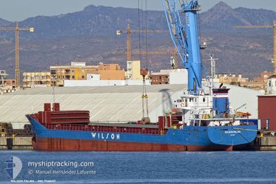
WILSON PALMA
General Cargo
Current Trip
| Time Travelled | 11 h, 35 mins |
|---|---|
| Remaining Time | 1 day |
| Distance Travelled | 128.69 морская миля |
| Remaining Distance | 300.37 морская миля |
| AVG Speed | 11.3 Узлы |
| MAX Speed | 14.2 Узлы |
| AVG Wind | 6.2 knots |
| MAX Wind | 9 knots |
| MIN Temp | 12.5°C / 54.5°F |
| MAX Temp | 21.5°C / 70.7°F |
| Осадка | 4.3 м |
| Позиция Получена | 2 m тому назад |
Current Position
| Долгота | 3.15380° |
|---|---|
| Широта | 52.13926° |
| Статус | Under way using engine |
| Скорость | 12.7 Узлы |
| Курс | 44.2° |
| Район | North Sea |
| Станция | T-AIS |
| Позиция Получена | 2 m тому назад |
Info
Information
The current position of WILSON PALMA is in North Sea with coordinates 52.13926° / 3.15380° as reported on 2024-05-10 02:04 by AIS to our vessel tracker app. The vessel's current speed is 12.7 Узлы and is heading at the port of HAMBURG. The estimated time of arrival as calculated by MyShipTracking vessel tracking app is 2024-05-11 03:40 LT
The vessel WILSON PALMA (IMO: 9368417, MMSI: 257237000) is a General Cargo that was built in 2009 ( 15 лет ). It's sailing under the flag of [NO] Norway.
In this page you can find informations about the vessels current position, last detected port calls, and current voyage information. If the vessels is not in coverage by AIS you will find the latest position.
The current position of WILSON PALMA is detected by our AIS receivers and we are not responsible for the reliability of the data. The last position was recorded while the vessel was in Coverage by the Ais receivers of our vessel tracking app.
The current draught of WILSON PALMA as reported by AIS is 4.3 meters
Weather
| Temperature | 12.5°C / 54.5°F |
|---|---|
| Wind Speed | 3 knots |
| Direction | 69° ENE |
| Pressure | 1024.5 hPa |
| Humidity | 75.2 % |
| Cloud Coverage | 42 % |
Featured Company
Last Port Calls
| Port | Arrival | Departure | Time In Port |
|---|---|---|---|
| 2024-05-06 17:48 | 2024-05-09 14:31 | 2 d | |
| 2024-05-01 20:48 | 2024-05-02 17:58 | 21 h | |
| 2024-04-26 15:50 | 2024-04-30 18:17 | 4 d | |
| 2024-04-18 01:23 | 2024-04-19 15:41 | 1 d | |
| 2024-04-16 16:40 | 2024-04-17 18:21 | 1 d | |
| 2024-03-27 06:41 | 2024-04-11 02:57 | 14 d | |
| 2024-03-19 10:06 | 2024-03-20 12:46 | 1 d | |
| 2024-03-13 18:51 | 2024-03-18 19:14 | 5 d | |
| 2024-03-06 23:51 | 2024-03-07 16:42 | 16 h | |
| 2024-03-04 04:27 | 2024-03-05 17:34 | 1 d |
Last Trips
| Origin | Departure | Destination | Arrival | Distance | |
|---|---|---|---|---|---|
| 2024-05-02 18:58 | 2024-05-06 18:48 | 905.10 морская миля | |||
| 2024-04-30 19:17 | 2024-05-01 21:48 | 213.98 морская миля | |||
| 2024-04-19 16:41 | 2024-04-26 16:50 | 1083.85 морская миля | |||
| 2024-04-17 19:21 | 2024-04-18 02:23 | 73.27 морская миля | |||
| 2024-04-11 04:57 | 2024-04-16 17:40 | 1165.63 морская миля | |||
| 2024-03-20 12:46 | 2024-03-27 07:41 | 1516.48 морская миля | |||
| 2024-03-18 19:14 | 2024-03-19 10:06 | 158.31 морская миля | |||
| 2024-03-07 17:42 | 2024-03-13 18:51 | 1423.60 морская миля | |||
| 2024-03-05 18:34 | 2024-03-07 00:51 | 125.64 морская миля | |||
| 2024-02-13 20:38 | 2024-03-04 05:27 | 3330.56 морская миля |
Events
| Время | Событие | Детали | Позиция / Направление | Информация |
|---|---|---|---|---|
| 2024-05-09 23:47 | Обнаружено в море | Dutch part of the North Sea |
51.81294 / 2.63868
North Sea
GBNFT => DEHAM
|
Скорость: 10.7 kn Курс: 41.1° |
| 2024-05-09 21:35 | Обнаружено в море | Belgian part of the North Sea |
51.54047 / 2.25088
North Sea
GBNFT => DEHAM
|
Скорость: 9.2 kn Курс: 40° |
| 2024-05-09 20:29 | Изменение морского района | French part of the North Sea United Kingdom part of the North Sea |
51.41292 / 2.07935
North Sea
GBNFT => DEHAM
|
Скорость: 8.9 kn Курс: 38.8° |
| 2024-05-09 14:32 | Начало движения | 0.21 nm, North of NORTHFLEET |
51.45463 / .32979
GBNFT => DEHAM
|
Скорость: 5.5 kn Курс: 112.3° |
| 2024-05-09 14:31 | ПОРТ ОТПРАВЛЕНИЯ |
|
51.45471 / .32948
GBNFT => DEHAM
|
Скорость: 5 kn Курс: 112° |
| 2024-05-09 14:24 | Статус изменился | Under way using engine Moored |
51.45387 / .32690
[GB] NORTHFLEET
|
Скорость: Курс: 326° |
| 2024-05-09 14:13 | Осадка изменилась | 4.3 5.8 |
51.45383 / .32681
[GB] NORTHFLEET
|
Скорость: Курс: 325° |
| 2024-05-09 13:58 | Пункт назначения изменился | GBNFT => DEHAM PTLEI => GBNFT |
51.45389 / .32687
[GB] NORTHFLEET
|
Скорость: Курс: 326° |
| 2024-05-09 13:58 | ETA изменился | 2024/05/11 02:00 2024/05/06 15:00 |
51.45389 / .32687
[GB] NORTHFLEET
|
Скорость: Курс: 326° |
| 2024-05-06 18:10 | Статус изменился | Moored Under way using engine |
51.45387 / .32686
[GB] NORTHFLEET
|
Скорость: Курс: 327° |