
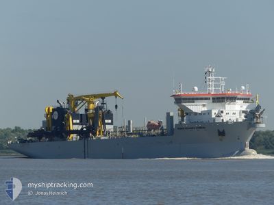
PEDRO ALVARES CABRAL
Trailing Suction Hopper Dredger
Current Trip
HORNSEA PROJECT
| Time Travelled | 15 days |
|---|---|
| Remaining Time | --- |
| Distance Travelled | 952.20 морская миля |
| Remaining Distance | --- |
| AVG Speed | 7.1 Узлы |
| MAX Speed | 17.1 Узлы |
| AVG Wind | 19.2 knots |
| MAX Wind | 34 knots |
| MIN Temp | 4.4°C / 39.92°F |
| MAX Temp | 11.8°C / 53.24°F |
| Осадка | 7.3 м |
| Позиция Получена | Сейчас |
Current Position
| Долгота | --- |
|---|---|
| Широта | --- |
| Статус | Restricted manoeuverability |
| Скорость | 16.2 Узлы |
| Курс | 87° |
| Район | North Sea |
| Станция | T-AIS |
| Позиция Получена | Сейчас |
Info
Information
The current position of PEDRO ALVARES CABRAL is in North Sea with coordinates 53.08525° / 1.41958° as reported on 2025-12-06 05:08 by AIS to our vessel tracker app. The vessel's current speed is 16.2 Узлы
The vessel PEDRO ALVARES CABRAL (IMO: 9606132, MMSI: 253365000) is a Trailing Suction Hopper Dredger that was built in 2012 ( 13 лет ). It's sailing under the flag of [LU] Luxembourg.
In this page you can find informations about the vessels current position, last detected port calls, and current voyage information. If the vessels is not in coverage by AIS you will find the latest position.
The current position of PEDRO ALVARES CABRAL is detected by our AIS receivers and we are not responsible for the reliability of the data. The last position was recorded while the vessel was in Coverage by the Ais receivers of our vessel tracking app.
The current draught of PEDRO ALVARES CABRAL as reported by AIS is 7.3 meters
Weather
| Temperature | 9.6°C / 49.28°F |
|---|---|
| Wind Speed | 18 knots |
| Direction | 195° SSW |
| Pressure | 991.7 hPa |
| Humidity | 89.1 % |
| Cloud Coverage | 91 % |
Featured Company
Most Visited Ports (Last year)
| Port | Arrivals | |
|---|---|---|
| 66 | ||
| 24 | ||
| 3 | ||
| 2 | ||
| 1 | ||
| 1 |
Events
| Время | Событие | Детали | Позиция / Направление | Информация |
|---|---|---|---|---|
| 2025-12-06 04:15 | Начало движения | 9.54 nm, North East of WELLS-NEXT-THE-SEA |
53.04205 / 1.08949
HORNSEA PROJECT
|
Скорость: 3.1 kn Курс: 230° |
| 2025-12-06 03:42 | Окончание движения | 9.72 nm, North East of WELLS-NEXT-THE-SEA |
53.04572 / 1.09218
HORNSEA PROJECT
|
Скорость: 0.3 kn Курс: 92° |
| 2025-12-06 03:07 | Начало движения | 9.52 nm, North East of WELLS-NEXT-THE-SEA |
53.04573 / 1.08607
HORNSEA PROJECT
|
Скорость: 3.4 kn Курс: 184° |
| 2025-12-06 01:17 | Окончание движения | 9.29 nm, North East of WELLS-NEXT-THE-SEA |
53.04494 / 1.07941
HORNSEA PROJECT
|
Скорость: 0.3 kn Курс: 46° |
| 2025-12-06 01:11 | Начало движения | 9.36 nm, North East of WELLS-NEXT-THE-SEA |
53.04178 / 1.08445
HORNSEA PROJECT
|
Скорость: 3.1 kn Курс: 28° |
| 2025-12-05 22:37 | Окончание движения | 9.34 nm, North East of WELLS-NEXT-THE-SEA |
53.03996 / 1.08512
HORNSEA PROJECT
|
Скорость: 0.2 kn Курс: 130° |
| 2025-12-05 22:07 | Начало движения | 9.5 nm, North East of WELLS-NEXT-THE-SEA |
53.04563 / 1.08556
HORNSEA PROJECT
|
Скорость: 3.1 kn Курс: 196° |
| 2025-12-05 21:07 | Статус изменился | Restricted manoeuverability Default |
53.04470 / 1.08515
HORNSEA PROJECT
|
Скорость: 0.9 kn Курс: 215° |
| 2025-12-05 20:57 | Статус изменился | Default Restricted manoeuverability |
53.04528 / 1.08579
HORNSEA PROJECT
|
Скорость: Курс: 235° |
| 2025-12-05 20:41 | Статус изменился | Restricted manoeuverability Default |
53.04536 / 1.08562
HORNSEA PROJECT
|
Скорость: 0.8 kn Курс: 224° |