
NORDBORG
General Cargo
Current Trip
| Time Travelled | 1 day |
|---|---|
| Remaining Time | 2 days |
| Distance Travelled | 343.48 морская миля |
| Remaining Distance | 630.18 морская миля |
| AVG Speed | 9.9 Узлы |
| MAX Speed | 10.4 Узлы |
| AVG Wind | 7.6 knots |
| MAX Wind | 16 knots |
| MIN Temp | 7.9°C / 46.22°F |
| MAX Temp | 15.5°C / 59.9°F |
| Осадка | 6.3 м |
| Позиция Получена | 1 m тому назад |
Current Position
| Долгота | 12.70811° |
|---|---|
| Широта | 55.30534° |
| Статус | Under way using engine |
| Скорость | 10.2 Узлы |
| Курс | 293.4° |
| Район | Baltic Sea |
| Станция | T-AIS |
| Позиция Получена | 1 m тому назад |
Info
Information
The current position of NORDBORG is in Baltic Sea with coordinates 55.30534° / 12.70811° as reported on 2024-05-15 06:11 by AIS to our vessel tracker app. The vessel's current speed is 10.2 Узлы and is heading at the port of NEW HOLLAND. The estimated time of arrival as calculated by MyShipTracking vessel tracking app is 2024-05-17 21:30 LT
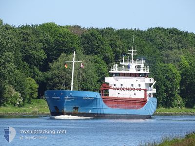
The vessel NORDBORG (IMO: 9148180, MMSI: 245157000) is a General Cargo that was built in 1999 ( 25 лет ). It's sailing under the flag of [NL] Netherlands.
In this page you can find informations about the vessels current position, last detected port calls, and current voyage information. If the vessels is not in coverage by AIS you will find the latest position.
The current position of NORDBORG is detected by our AIS receivers and we are not responsible for the reliability of the data. The last position was recorded while the vessel was in Coverage by the Ais receivers of our vessel tracking app.
The current draught of NORDBORG as reported by AIS is 6.3 meters
Weather
| Temperature | 10.9°C / 51.62°F |
|---|---|
| Wind Speed | 16 knots |
| Direction | 95° E |
| Pressure | 1016.4 hPa |
| Humidity | 88 % |
| Cloud Coverage | 16 % |
Featured Company
Last Port Calls
| Port | Arrival | Departure | Time In Port |
|---|---|---|---|
| 2024-05-06 17:22 | 2024-05-13 21:29 | 7 d | |
| 2024-05-03 21:32 | 2024-05-04 21:28 | 23 h | |
| 2024-05-01 10:16 | 2024-05-02 17:47 | 1 d | |
| 2024-04-25 05:32 | 2024-04-26 13:30 | 1 d | |
| 2024-04-23 11:50 | 2024-04-25 02:54 | 1 d | |
| 2024-04-16 11:47 | 2024-04-18 12:23 | 2 d | |
| 2024-04-12 08:57 | 2024-04-15 22:13 | 3 d | |
| 2024-04-10 08:37 | 2024-04-11 08:10 | 23 h | |
| 2024-04-09 19:19 | 2024-04-09 19:57 | 38 m | |
| 2024-04-06 17:40 | 2024-04-09 14:17 | 2 d |
Last Trips
| Origin | Departure | Destination | Arrival | Distance | |
|---|---|---|---|---|---|
| 2024-05-04 21:28 | 2024-05-06 17:22 | 470.18 морская миля | |||
| 2024-05-02 17:47 | 2024-05-03 21:32 | 271.94 морская миля | |||
| 2024-04-26 13:30 | 2024-05-01 10:16 | 1203.09 морская миля | |||
| 2024-04-25 02:54 | 2024-04-25 05:32 | 26.66 морская миля | |||
| 2024-04-18 12:23 | 2024-04-23 11:50 | 1075.48 морская миля | |||
| 2024-04-15 22:13 | 2024-04-16 11:47 | 127.74 морская миля | |||
| 2024-04-11 08:10 | 2024-04-12 08:57 | 225.40 морская миля | |||
| 2024-04-09 19:57 | 2024-04-10 08:37 | 89.81 морская миля | |||
| 2024-04-09 14:17 | 2024-04-09 19:19 | 48.60 морская миля | |||
| 2024-04-06 12:58 | 2024-04-06 17:40 | 48.38 морская миля |
Events
| Время | Событие | Детали | Позиция / Направление | Информация |
|---|---|---|---|---|
| 2024-05-14 22:53 | Изменение морского района | Swedish part of the Baltic Sea Danish part of the Kattegat |
55.45332 / 14.67496
Baltic Sea
GBNHO
|
Скорость: 10 kn Курс: 239.1° |
| 2024-05-14 20:38 | Изменение морского района | Danish part of the Kattegat Swedish part of the Baltic Sea |
55.64236 / 15.23919
Kattegat
GBNHO
|
Скорость: 9.8 kn Курс: 239.3° |
| 2024-05-14 14:52 | Статус изменился | Under way using engine Default |
56.14838 / 16.69843
GBNHO
|
Скорость: 10.2 kn Курс: 231° |
| 2024-05-14 14:48 | Статус изменился | Default Under way using engine |
56.15405 / 16.71088
GBNHO
|
Скорость: 10.1 kn Курс: 230.9° |
| 2024-05-14 14:33 | Статус изменился | Under way using engine Default |
56.18071 / 16.76932
GBNHO
|
Скорость: 10.1 kn Курс: 231° |
| 2024-05-14 14:33 | В покрытии |
56.18071 / 16.76932
Baltic Sea
GBNHO
|
Скорость: 10.1 kn Курс: 230.6° |
|
| 2024-05-14 13:37 | Статус изменился | Default Under way using engine |
56.31419 / 16.89702
GBNHO
|
Скорость: 10.1 kn Курс: 196.3° |
| 2024-05-14 13:30 | Статус изменился | Under way using engine Default |
56.33170 / 16.90593
GBNHO
|
Скорость: 10.1 kn Курс: 196° |
| 2024-05-14 13:30 | Вне покрытия |
56.33170 / 16.90593
Baltic Sea
GBNHO
|
Скорость: 10.1 kn Курс: 196.3° |
|
| 2024-05-14 13:16 | Статус изменился | Default Under way using engine |
56.36841 / 16.92407
GBNHO
|
Скорость: 10 kn Курс: 195.8° |