
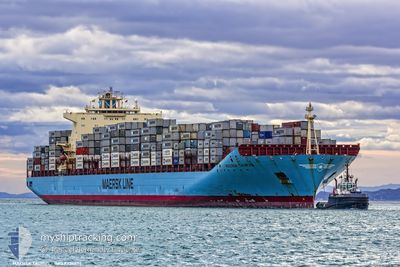
MAERSK TANJONG
Container Ship
Current Trip
| Time Travelled | 28 days |
|---|---|
| Remaining Time | --- |
| Distance Travelled | 11194.01 морская миля |
| Remaining Distance | 127.91 морская миля |
| AVG Speed | 17.2 Узлы |
| MAX Speed | 20.2 Узлы |
| AVG Wind | 13.8 knots |
| MAX Wind | 28.5 knots |
| MIN Temp | 5.8°C / 42.44°F |
| MAX Temp | 28.2°C / 82.76°F |
| Осадка | 13.5 м |
| Позиция Получена | 9 d тому назад |
Current Position
| Долгота | --- |
|---|---|
| Широта | --- |
| Статус | Under way using engine |
| Скорость | 18.7 Узлы |
| Курс | 128.2° |
| Район | South Atlantic Ocean |
| Станция | T-AIS |
| Позиция Получена | 9 d тому назад |
Info
Information
The current position of MAERSK TANJONG is in South Atlantic Ocean with coordinates -34.51390° / 17.63041° as reported on 2025-11-29 00:38 by AIS to our vessel tracker app. The vessel's current speed is 18.7 Узлы and is heading at the port of COLOMBO. The estimated time of arrival as calculated by MyShipTracking vessel tracking app is 2025-12-09 06:00 LT
The vessel MAERSK TANJONG (IMO: 9332511, MMSI: 477178400) is a Container Ship that was built in 2007 ( 18 лет ). It's sailing under the flag of [HK] Hong Kong.
In this page you can find informations about the vessels current position, last detected port calls, and current voyage information. If the vessels is not in coverage by AIS you will find the latest position.
The current position of MAERSK TANJONG is detected by our AIS receivers and we are not responsible for the reliability of the data. The last position was recorded while the vessel was in Coverage by the Ais receivers of our vessel tracking app.
The current draught of MAERSK TANJONG as reported by AIS is 13.5 meters
Weather
| Temperature | 27.3°C / 81.14°F |
|---|---|
| Wind Speed | 20 knots |
| Direction | 15° NNE |
| Pressure | 1011.5 hPa |
| Humidity | 80 % |
| Cloud Coverage | 41 % |
Featured Company
Last Port Calls
Most Visited Ports (Last year)
| Port | Arrivals | |
|---|---|---|
| 6 | ||
| 5 | ||
| 4 | ||
| 3 | ||
| 3 | ||
| 3 |
Last Trips
| Origin | Departure | Destination | Arrival | Distance | |
|---|---|---|---|---|---|
| 2025-11-05 23:47 | 2025-11-09 06:22 | 530.44 морская миля | |||
| 2025-11-04 03:21 | 2025-11-04 12:37 | 149.72 морская миля | |||
| 2025-10-28 03:09 | 2025-11-02 16:56 | 1430.87 морская миля | |||
| 2025-10-04 11:19 | 2025-10-27 12:57 | 9605.52 морская миля | |||
| 2025-09-29 01:42 | 2025-10-02 08:25 | 703.78 морская миля |
Events
| Время | Событие | Детали | Позиция / Направление | Информация |
|---|---|---|---|---|
| 2025-12-01 12:27 | Начало движения |
-30.20580 / 37.91635
LKCMB
|
Скорость: 5.4 kn Курс: 95° |
|
| 2025-12-01 12:20 | Окончание движения |
-30.20167 / 37.91000
LKCMB
|
Скорость: Курс: -1° |
|
| 2025-11-29 00:41 | Статус изменился | Default Under way using engine |
-34.52356 / 17.64512
LKCMB
|
Скорость: 18.7 kn Курс: 128.2° |
| 2025-11-29 00:38 | Вне покрытия |
-34.51390 / 17.63041
South Atlantic Ocean
LKCMB
|
Скорость: 18.7 kn Курс: 128.2° |
|
| 2025-11-29 00:35 | Обнаружено в море | South African part of the South Atlantic Ocean |
-34.50356 / 17.61469
South Atlantic Ocean
LKCMB
|
Скорость: 18.7 kn Курс: 128.4° |
| 2025-11-29 00:35 | Статус изменился | Under way using engine Default |
-34.50356 / 17.61469
LKCMB
|
Скорость: 18.7 kn Курс: 129° |
| 2025-11-29 00:30 | В покрытии |
-34.50356 / 17.61469
South Atlantic Ocean
LKCMB
|
Скорость: 18.7 kn Курс: 128.4° |