
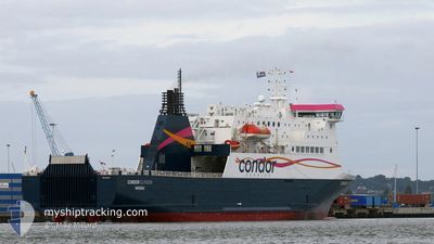
CONDOR ISLANDER
Ro-Ro/Passenger Ship
Current Trip
| Trip Time | 2 h, 53 mins |
|---|---|
| Trip Distance | 11.59 морская миля |
| AVG Speed | 9.4 Узлы |
| MAX Speed | 15.9 Узлы |
| Осадка | 5.2 м |
| AVG Wind | 14 knots |
| MAX Wind | 14.6 knots |
| MIN Temp | 10.1°C / 50.18°F |
| MAX Temp | 10.7°C / 51.26°F |
| Позиция Получена | Сейчас |
Current Position
| Долгота | -1.09451° |
|---|---|
| Широта | 50.81239° |
| Статус | Under way using engine |
| Скорость | |
| Курс | 218° |
| Район | English Channel |
| Станция | T-AIS |
| Позиция Получена | Сейчас |
Info
Information
The current position of CONDOR ISLANDER is in English Channel with coordinates 50.81239° / -1.09451° as reported on 2024-04-28 23:07 by AIS to our vessel tracker app. The vessel's current speed is 0 Узлы and is currently inside the port of PORTSMOUTH.
The vessel CONDOR ISLANDER (IMO: 9323704, MMSI: 311001287) is a Ro-Ro/Passenger Ship that was built in 2005 ( 19 лет ). It's sailing under the flag of [BS] Bahamas.
In this page you can find informations about the vessels current position, last detected port calls, and current voyage information. If the vessels is not in coverage by AIS you will find the latest position.
The current position of CONDOR ISLANDER is detected by our AIS receivers and we are not responsible for the reliability of the data. The last position was recorded while the vessel was in Coverage by the Ais receivers of our vessel tracking app.
The current draught of CONDOR ISLANDER as reported by AIS is 5.2 meters
Weather
| Temperature | 9.4°C / 48.92°F |
|---|---|
| Wind Speed | 11 knots |
| Direction | 229° SW |
| Pressure | 1014.2 hPa |
| Humidity | 80.7 % |
| Cloud Coverage | 8 % |
Featured Company
Last Port Calls
| Port | Arrival | Departure | Time In Port |
|---|---|---|---|
| 2024-04-28 18:21 | |||
| 2024-04-28 05:34 | 2024-04-28 15:28 | 9 h | |
| 2024-04-27 18:30 | 2024-04-27 21:19 | 2 h | |
| 2024-04-27 15:05 | 2024-04-27 16:27 | 1 h | |
| 2024-04-27 05:05 | 2024-04-27 09:09 | 4 h | |
| 2024-04-26 18:42 | 2024-04-26 21:12 | 2 h | |
| 2024-04-26 15:07 | 2024-04-26 17:05 | 1 h | |
| 2024-04-26 05:14 | 2024-04-26 09:00 | 3 h | |
| 2024-04-25 18:50 | 2024-04-25 21:30 | 2 h | |
| 2024-04-25 14:56 | 2024-04-25 17:12 | 2 h |
Most Visited Ports (Last year)
| Port | Arrivals | |
|---|---|---|
| 146 | ||
| 125 | ||
| 87 | ||
| 4 | ||
| 1 | ||
| 1 |
Last Trips
| Origin | Departure | Destination | Arrival | Distance | |
|---|---|---|---|---|---|
| 2024-04-28 16:28 | 2024-04-28 19:21 | 11.59 морская миля | |||
| 2024-04-27 22:19 | 2024-04-28 06:34 | 121.91 морская миля | |||
| 2024-04-27 17:27 | 2024-04-27 19:30 | 27.80 морская миля | |||
| 2024-04-27 10:09 | 2024-04-27 16:05 | 106.50 морская миля | |||
| 2024-04-26 22:12 | 2024-04-27 06:05 | 123.59 морская миля | |||
| 2024-04-26 18:05 | 2024-04-26 19:42 | 27.80 морская миля | |||
| 2024-04-26 10:00 | 2024-04-26 16:07 | 107.95 морская миля | |||
| 2024-04-25 22:30 | 2024-04-26 06:14 | 123.70 морская миля | |||
| 2024-04-25 18:12 | 2024-04-25 19:50 | 27.88 морская миля | |||
| 2024-04-25 09:51 | 2024-04-25 15:56 | 108.02 морская миля |
Events
| Время | Событие | Детали | Позиция / Направление | Информация |
|---|---|---|---|---|
| 2024-04-28 18:32 | Окончание движения |
50.81238 / -1.09462
[GB] PORTSMOUTH
|
Скорость: 0.3 kn Курс: 220° |
|
| 2024-04-28 18:21 | Порт |
|
50.81092 / -1.10657
[GB] PORTSMOUTH
|
Скорость: 8.3 kn Курс: 66.2° |
| 2024-04-28 18:09 | Статус изменился | Under way using engine At anchor |
50.78328 / -1.10400
PORTSMOUTH
|
Скорость: 9 kn Курс: 323.1° |
| 2024-04-28 17:42 | Начало движения | 2.53 nm, North East of ST HELENS |
50.72286 / -1.05966
PORTSMOUTH
|
Скорость: 5 kn Курс: 345.2° |
| 2024-04-28 16:21 | Статус изменился | At anchor Moored |
50.72223 / -1.05705
PORTSMOUTH
|
Скорость: 0.7 kn Курс: 272° |
| 2024-04-28 16:12 | Окончание движения | 2.56 nm, North East of ST HELENS |
50.72175 / -1.05719
PORTSMOUTH
|
Скорость: 0.3 kn Курс: 233° |
| 2024-04-28 15:28 | ПОРТ ОТПРАВЛЕНИЯ |
|
50.78605 / -1.10725
PORTSMOUTH
|
Скорость: 10.4 kn Курс: 155° |
| 2024-04-28 15:15 | Начало движения |
50.81076 / -1.09947
[GB] PORTSMOUTH
|
Скорость: 4 kn Курс: 274° |
|
| 2024-04-28 06:01 | Статус изменился | Moored Under way using engine |
50.81094 / -1.09654
[GB] PORTSMOUTH
|
Скорость: Курс: 261° |
| 2024-04-28 05:48 | Окончание движения |
50.81091 / -1.09661
[GB] PORTSMOUTH
|
Скорость: 0.3 kn Курс: 260° |