
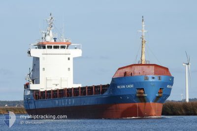
WILSON CADIZ
General Cargo
Current Trip
| Time Travelled | 2 days |
|---|---|
| Remaining Time | 10 h, 26 mins |
| Distance Travelled | 691.44 nm |
| Remaining Distance | 118.37 nm |
| AVG Speed | 10.3 Knopen |
| MAX Speed | 14.2 Knopen |
| AVG Wind | 9.5 knots |
| MAX Wind | 20.9 knots |
| MIN Temp | 1.9°C / 35.42°F |
| MAX Temp | 10.9°C / 51.62°F |
| Diepgang | 5.9 M |
| Positie ontvangen | 1 h, 14 m geleden |
Current Position
| Lengtegraad | -5.87902° |
|---|---|
| Breedtegraat | 50.29011° |
| Status | Under way using engine |
| Snelheid | 11.2 Knopen |
| Koers | 355.6° |
| Gebied | Celtic Sea |
| Station | T-AIS |
| Positie ontvangen | 1 h, 14 m geleden |
Info
Information
The current position of WILSON CADIZ is in Celtic Sea with coordinates 50.29011° / -5.87902° as reported on 2024-04-27 14:56 by AIS to our vessel tracker app. The vessel's current speed is 11.2 Knopen and is heading at the port of WATERFORD. The estimated time of arrival as calculated by MyShipTracking vessel tracking app is 2024-04-28 02:36 LT
The vessel WILSON CADIZ (IMO: 9192612, MMSI: 314216000) is a General Cargo that was built in 2000 ( 24 Jaar oud ). It's sailing under the flag of [BB] Barbados.
In this page you can find informations about the vessels current position, last detected port calls, and current voyage information. If the vessels is not in coverage by AIS you will find the latest position.
The current position of WILSON CADIZ is detected by our AIS receivers and we are not responsible for the reliability of the data. The last position was recorded while the vessel was in Coverage by the Ais receivers of our vessel tracking app.
The current draught of WILSON CADIZ as reported by AIS is 5.9 meters
Weather
| Temperature | 9.3°C / 48.74°F |
|---|---|
| Wind Speed | 17 knots |
| Direction | 43° NE |
| Pressure | 1002.4 hPa |
| Humidity | 79 % |
| Cloud Coverage | 98 % |
Featured Company
Last Port Calls
| Port | Arrival | Departure | Time In Port |
|---|---|---|---|
| 2024-04-24 19:59 | 2024-04-24 20:59 | 1 h | |
| 2024-04-21 08:56 | 2024-04-23 00:09 | 1 d | |
| 2024-04-15 20:45 | 2024-04-21 07:50 | 5 d | |
| 2024-03-27 16:50 | 2024-04-15 07:12 | 18 d | |
| 2024-03-24 09:41 | 2024-03-26 15:04 | 2 d | |
| 2024-03-21 19:11 | 2024-03-21 23:44 | 4 h | |
| 2024-03-14 03:25 | 2024-03-19 17:51 | 5 d | |
| 2024-03-10 01:15 | 2024-03-14 00:45 | 3 d | |
| 2024-03-04 10:42 | 2024-03-06 18:47 | 2 d | |
| 2024-02-28 21:27 | 2024-03-03 10:20 | 3 d |
Most Visited Ports (Last year)
| Port | Arrivals | |
|---|---|---|
| 5 | ||
| 3 | ||
| 3 | ||
| 3 | ||
| 3 | ||
| 3 |
Last Trips
| Origin | Departure | Destination | Arrival | Distance | |
|---|---|---|---|---|---|
| 2024-04-23 02:09 | 2024-04-24 21:59 | 409.48 nm | |||
| 2024-04-21 09:50 | 2024-04-21 10:56 | 11.21 nm | |||
| 2024-04-15 09:12 | 2024-04-15 22:45 | 129.57 nm | |||
| 2024-03-26 16:04 | 2024-03-27 17:50 | 301.88 nm | |||
| 2024-03-22 00:44 | 2024-03-24 10:41 | 516.60 nm | |||
| 2024-03-19 18:51 | 2024-03-21 20:11 | 553.01 nm | |||
| 2024-03-14 01:45 | 2024-03-14 04:25 | 28.69 nm | |||
| 2024-03-06 18:47 | 2024-03-10 02:15 | 787.83 nm | |||
| 2024-03-03 11:20 | 2024-03-04 10:42 | 233.55 nm | |||
| 2024-02-26 08:57 | 2024-02-28 22:27 | 444.06 nm |
Events
| Tijd | Evenement | Details | Positie / Bestemming | Info |
|---|---|---|---|---|
| 2024-04-27 15:02 | Status Changed | Default Under way using engine |
50.30992 / -5.88128
WATERFORD
|
Snelheid: 11.2 kn Koers: 355.6° |
| 2024-04-27 14:56 | Status Changed | Under way using engine Default |
50.29011 / -5.87902
WATERFORD
|
Snelheid: 11.3 kn Koers: 356° |
| 2024-04-27 14:56 | Buitenbereik |
50.29011 / -5.87902
Celtic Sea
WATERFORD
|
Snelheid: 11.2 kn Koers: 355.6° |
|
| 2024-04-27 14:47 | Status Changed | Default Under way using engine |
50.26118 / -5.87579
WATERFORD
|
Snelheid: 11.4 kn Koers: 354.7° |
| 2024-04-27 14:22 | Status Changed | Under way using engine Default |
50.18310 / -5.86962
WATERFORD
|
Snelheid: 11.4 kn Koers: 1° |
| 2024-04-27 14:02 | Status Changed | Default Under way using engine |
50.12169 / -5.87325
WATERFORD
|
Snelheid: 11.4 kn Koers: 359.5° |
| 2024-04-27 13:54 | Status Changed | Under way using engine Default |
50.09546 / -5.87394
WATERFORD
|
Snelheid: 11.3 kn Koers: 2° |
| 2024-04-27 13:42 | Status Changed | Default Under way using engine |
50.05937 / -5.87465
WATERFORD
|
Snelheid: 11.2 kn Koers: 359.7° |
| 2024-04-27 13:35 | Wijzig zee gebeid | United Kingdom part of the Celtic Sea United Kingdom part of the English Channel |
50.03448 / -5.87499
Celtic Sea
WATERFORD
|
Snelheid: 11.3 kn Koers: 0.3° |
| 2024-04-27 13:35 | Status Changed | Under way using engine Default |
50.03448 / -5.87499
WATERFORD
|
Snelheid: 11.3 kn Koers: 0° |