
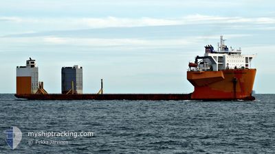
WHITE MARLIN
Cargo
Current Trip
| Time Travelled | 32 days |
|---|---|
| Remaining Time | 20 days |
| Distance Travelled | 6055.14 nm |
| Remaining Distance | 4960.73 nm |
| AVG Speed | 9.6 Knopen |
| MAX Speed | 12.2 Knopen |
| AVG Wind | 13.1 knots |
| MAX Wind | 24.9 knots |
| MIN Temp | 14.5°C / 58.1°F |
| MAX Temp | 31.6°C / 88.88°F |
| Diepgang | 7.8 M |
| Positie ontvangen | 2 d geleden |
Current Position
| Lengtegraad | 19.12890° |
|---|---|
| Breedtegraat | -34.91038° |
| Status | Under way using engine |
| Snelheid | 11.6 Knopen |
| Koers | 110.2° |
| Gebied | South Atlantic Ocean |
| Station | T-AIS |
| Positie ontvangen | 2 d geleden |
Info
Information
The current position of WHITE MARLIN is in South Atlantic Ocean with coordinates -34.91038° / 19.12890° as reported on 2024-05-01 02:39 by AIS to our vessel tracker app. The vessel's current speed is 11.6 Knopen and is heading at the port of SINGAPORE. The estimated time of arrival as calculated by MyShipTracking vessel tracking app is 2024-05-24 04:24 LT
The vessel WHITE MARLIN (IMO: 9670224, MMSI: 248750000) is a Cargo It's sailing under the flag of [MT] Malta.
In this page you can find informations about the vessels current position, last detected port calls, and current voyage information. If the vessels is not in coverage by AIS you will find the latest position.
The current position of WHITE MARLIN is detected by our AIS receivers and we are not responsible for the reliability of the data. The last position was recorded while the vessel was in Coverage by the Ais receivers of our vessel tracking app.
The current draught of WHITE MARLIN as reported by AIS is 7.8 meters
Weather
| Temperature | 23.9°C / 75.02°F |
|---|---|
| Wind Speed | 22 knots |
| Direction | 19° NNE |
| Pressure | 1021.3 hPa |
| Humidity | 83.1 % |
| Cloud Coverage | --- |
Featured Company
Last Port Calls
| Port | Arrival | Departure | Time In Port |
|---|---|---|---|
| 2024-04-01 19:27 |
Most Visited Ports (Last year)
| Port | Arrivals | |
|---|---|---|
| 7 | ||
| 3 | ||
| 2 | ||
| 1 | ||
| 1 |
Last Trips
| Origin | Departure | Destination | Arrival | Distance |
|---|
Events
| Tijd | Evenement | Details | Positie / Bestemming | Info |
|---|---|---|---|---|
| 2024-05-01 02:46 | Status Changed | Default Under way using engine |
-34.91772 / 19.15293
SG SIN
|
Snelheid: 11.6 kn Koers: 110.2° |
| 2024-05-01 02:39 | Buitenbereik |
-34.91038 / 19.12890
South Atlantic Ocean
SG SIN
|
Snelheid: 11.6 kn Koers: 110.2° |
|
| 2024-05-01 01:44 | Status Changed | Under way using engine Default |
-34.84875 / 18.92750
SG SIN
|
Snelheid: 11 kn Koers: 110° |
| 2024-05-01 01:09 | Status Changed | Default Under way using engine |
-34.81162 / 18.80602
SG SIN
|
Snelheid: 10.8 kn Koers: 109.3° |
| 2024-05-01 01:06 | Status Changed | Under way using engine Default |
-34.80826 / 18.79493
SG SIN
|
Snelheid: 11 kn Koers: 109° |
| 2024-05-01 00:14 | Status Changed | Default Under way using engine |
-34.75167 / 18.61167
SG SIN
|
Snelheid: 10.9 kn Koers: 110.4° |
| 2024-04-30 20:39 | Status Changed | Under way using engine Default |
-34.43585 / 17.96188
SG SIN
|
Snelheid: 9 kn Koers: 130° |
| 2024-04-30 20:21 | Status Changed | Default Under way using engine |
-34.40561 / 17.91747
SG SIN
|
Snelheid: 9.8 kn Koers: 127.7° |
| 2024-04-30 20:06 | Status Changed | Under way using engine Default |
-34.37852 / 17.87792
SG SIN
|
Snelheid: 9 kn Koers: 130° |
| 2024-04-30 19:50 | Status Changed | Default Under way using engine |
-34.35002 / 17.83573
SG SIN
|
Snelheid: 9.8 kn Koers: 129.9° |