
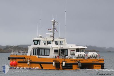
TSM WINDCAT 49
High speed craft
Current Trip
LEZARDRIEUX / SB OWF
| Time Travelled | --- |
|---|---|
| Remaining Time | --- |
| Distance Travelled | 2036.23 nm |
| Remaining Distance | --- |
| AVG Speed | 18.7 Knopen |
| MAX Speed | 18.7 Knopen |
| AVG Wind | 12.3 knots |
| MAX Wind | 25.8 knots |
| MIN Temp | 6.1°C / 42.98°F |
| MAX Temp | 19.3°C / 66.74°F |
| Diepgang | 2.5 M |
| Positie ontvangen | 6 m geleden |
Current Position
| Lengtegraad | -2.58221° |
|---|---|
| Breedtegraat | 48.87877° |
| Status | Under way using engine |
| Snelheid | 25.5 Knopen |
| Koers | 72.5° |
| Gebied | English Channel |
| Station | T-AIS |
| Positie ontvangen | 6 m geleden |
Info
Information
The current position of TSM WINDCAT 49 is in English Channel with coordinates 48.87877° / -2.58221° as reported on 2024-06-16 14:40 by AIS to our vessel tracker app. The vessel's current speed is 25.5 Knopen
The vessel TSM WINDCAT 49 (IMO: 9945760, MMSI: 228414700) is a High speed craft It's sailing under the flag of [FR] France.
In this page you can find informations about the vessels current position, last detected port calls, and current voyage information. If the vessels is not in coverage by AIS you will find the latest position.
The current position of TSM WINDCAT 49 is detected by our AIS receivers and we are not responsible for the reliability of the data. The last position was recorded while the vessel was in Coverage by the Ais receivers of our vessel tracking app.
The current draught of TSM WINDCAT 49 as reported by AIS is 2.5 meters
Weather
| Temperature | 14.7°C / 58.46°F |
|---|---|
| Wind Speed | 11 knots |
| Direction | 278° W |
| Pressure | 1006.6 hPa |
| Humidity | 76.8 % |
| Cloud Coverage | 44 % |
Featured Company
Last Port Calls
Most Visited Ports (Last year)
| Port | Arrivals | |
|---|---|---|
| 18 |
Last Trips
| Origin | Departure | Destination | Arrival | Distance |
|---|
Events
| Tijd | Evenement | Details | Positie / Bestemming | Info |
|---|---|---|---|---|
| 2024-06-16 14:38 | Start beweging | 16.3 nm, North East of SAINT QUAY PORTRIEUX |
48.87556 / -2.59573
LEZARDRIEUX / SB OWF
|
Snelheid: 12 kn Koers: 59.8° |
| 2024-06-16 14:38 | Status Changed | Under way using engine Default |
48.87444 / -2.59809
LEZARDRIEUX / SB OWF
|
Snelheid: Koers: 323° |
| 2024-06-16 14:35 | Status Changed | Default Under way using engine |
48.87460 / -2.59825
LEZARDRIEUX / SB OWF
|
Snelheid: Koers: 319° |
| 2024-06-16 14:25 | Stop beweging | 16.19 nm, North East of SAINT QUAY PORTRIEUX |
48.87458 / -2.59822
LEZARDRIEUX / SB OWF
|
Snelheid: 0.2 kn Koers: 321° |
| 2024-06-16 14:15 | Start beweging | 14.69 nm, North East of SAINT QUAY PORTRIEUX |
48.83172 / -2.57474
LEZARDRIEUX / SB OWF
|
Snelheid: 24.7 kn Koers: 340.7° |
| 2024-06-16 14:13 | Status Changed | Under way using engine Default |
48.82299 / -2.57098
LEZARDRIEUX / SB OWF
|
Snelheid: Koers: 323° |
| 2024-06-16 14:07 | Status Changed | Default Under way using engine |
48.82330 / -2.57129
LEZARDRIEUX / SB OWF
|
Snelheid: 18.3 kn Koers: 310.2° |
| 2024-06-16 14:07 | Stop beweging | 14.41 nm, North East of SAINT QUAY PORTRIEUX |
48.82330 / -2.57129
LEZARDRIEUX / SB OWF
|
Snelheid: Koers: 322° |
| 2024-06-16 14:00 | Start beweging | 14.38 nm, North East of SAINT QUAY PORTRIEUX |
48.81397 / -2.55781
LEZARDRIEUX / SB OWF
|
Snelheid: 18.3 kn Koers: 310.2° |
| 2024-06-16 13:53 | Gevonden in zee | French part of the English Channel |
48.81031 / -2.54940
English Channel
|
Snelheid: Koers: 5.7° |