
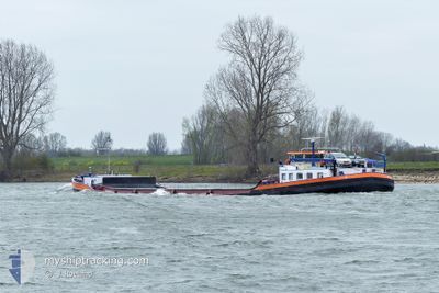
TAURUS
Cargo
Current Trip
| Time Travelled | 8 h, 27 mins |
|---|---|
| Remaining Time | 6 mins |
| Distance Travelled | 36.31 nm |
| Remaining Distance | 5.36 nm |
| AVG Speed | 6.9 Knopen |
| MAX Speed | 9.2 Knopen |
| AVG Wind | 14.4 knots |
| MAX Wind | 16 knots |
| MIN Temp | 10.4°C / 50.72°F |
| MAX Temp | 12.3°C / 54.14°F |
| Diepgang | 3.5 M |
| Positie ontvangen | 3 m geleden |
Current Position
| Lengtegraad | --- |
|---|---|
| Breedtegraat | --- |
| Status | Moored |
| Snelheid | 0.1 Knopen |
| Koers | 173° |
| Gebied | North Sea |
| Station | T-AIS |
| Positie ontvangen | 3 m geleden |
Info
Information
The current position of TAURUS is in North Sea with coordinates 52.58888° / 5.40914° as reported on 2025-12-10 16:30 by AIS to our vessel tracker app. The vessel's current speed is 0.1 Knopen and is heading at the port of LELYSTAD. The estimated time of arrival as calculated by MyShipTracking vessel tracking app is 2025-12-10 17:39 LT
The vessel TAURUS (MMSI: 244660225) is a Cargo It's sailing under the flag of [NL] Netherlands.
In this page you can find informations about the vessels current position, last detected port calls, and current voyage information. If the vessels is not in coverage by AIS you will find the latest position.
The current position of TAURUS is detected by our AIS receivers and we are not responsible for the reliability of the data. The last position was recorded while the vessel was in Coverage by the Ais receivers of our vessel tracking app.
The current draught of TAURUS as reported by AIS is 3.5 meters
Weather
| Temperature | 10.4°C / 50.72°F |
|---|---|
| Wind Speed | 16 knots |
| Direction | 228° SW |
| Pressure | 1016.8 hPa |
| Humidity | 83.1 % |
| Cloud Coverage | 99 % |
Featured Company
Last Port Calls
| Port | Arrival | Departure | Time In Port |
|---|---|---|---|
| 2025-12-10 07:53 | 2025-12-10 09:06 | 1 h | |
| 2025-12-04 14:21 | 2025-12-08 06:17 | 3 d | |
| 2025-11-27 23:24 | 2025-12-01 07:43 | 3 d | |
| 2025-11-27 11:51 | 2025-11-27 12:26 | 35 m | |
| 2025-11-27 07:57 | 2025-11-27 08:30 | 32 m | |
| 2025-11-26 12:15 | 2025-11-26 12:54 | 38 m | |
| 2025-11-26 07:33 | 2025-11-26 08:08 | 34 m | |
| 2025-11-25 11:46 | 2025-11-25 12:24 | 37 m | |
| 2025-11-25 07:29 | 2025-11-25 08:02 | 33 m | |
| 2025-11-24 10:05 | 2025-11-24 10:43 | 37 m |
Most Visited Ports (Last year)
| Port | Arrivals | |
|---|---|---|
| 65 | ||
| 29 | ||
| 27 | ||
| 18 | ||
| 16 | ||
| 16 |
Last Trips
| Origin | Departure | Destination | Arrival | Distance | |
|---|---|---|---|---|---|
| 2025-12-08 06:17 | 2025-12-10 07:53 | 128.42 nm | |||
| 2025-12-01 07:43 | 2025-12-04 14:21 | 233.63 nm | |||
| 2025-11-27 12:26 | 2025-11-27 23:24 | 21.14 nm | |||
| 2025-11-27 08:30 | 2025-11-27 11:51 | 8.10 nm | |||
| 2025-11-26 12:54 | 2025-11-27 07:57 | 50.31 nm | |||
| 2025-11-26 08:08 | 2025-11-26 12:15 | 8.13 nm | |||
| 2025-11-25 12:24 | 2025-11-26 07:33 | 49.81 nm | |||
| 2025-11-25 08:02 | 2025-11-25 11:46 | 7.75 nm | |||
| 2025-11-24 10:43 | 2025-11-25 07:29 | 49.70 nm | |||
| 2025-11-24 06:33 | 2025-11-24 10:05 | 7.03 nm |
Events
| Tijd | Evenement | Details | Positie / Bestemming | Info |
|---|---|---|---|---|
| 2025-12-10 16:08 | Status Changed | Moored Under way using engine |
52.58877 / 5.40930
LELYSTAD
|
Snelheid: 0.2 kn Koers: 180° |
| 2025-12-10 16:03 | Stop beweging | 2.83 nm, North West of FLEVO MARINA |
52.58878 / 5.40895
LELYSTAD
|
Snelheid: 0.3 kn Koers: 156° |
| 2025-12-10 15:56 | Start beweging | 3.16 nm, North West of FLEVO MARINA |
52.59368 / 5.40431
LELYSTAD
|
Snelheid: 5 kn Koers: 136° |
| 2025-12-10 15:51 | Stop beweging | 3.27 nm, North West of FLEVO MARINA |
52.59523 / 5.40282
LELYSTAD
|
Snelheid: 0.3 kn Koers: 151° |
| 2025-12-10 14:46 | Status Changed | Under way using engine Moored |
52.49844 / 5.33832
LELYSTAD
|
Snelheid: 7.6 kn Koers: 34° |
| 2025-12-10 12:43 | Start beweging | 0.14 nm, South West of SCHELLINGWOUDE |
52.37937 / 4.96203
LELYSTAD
|
Snelheid: 4.4 kn Koers: 111° |
| 2025-12-10 12:34 | Stop beweging | 0.21 nm, West of SCHELLINGWOUDE |
52.38012 / 4.95909
LELYSTAD
|
Snelheid: Koers: 113° |
| 2025-12-10 11:24 | Start beweging | 0.82 nm, South East of NAUERNA |
52.42862 / 4.76765
LELYSTAD
|
Snelheid: 4.2 kn Koers: 115° |
| 2025-12-10 08:40 | Status Changed | Moored Under way using engine |
52.42887 / 4.76594
LELYSTAD
|
Snelheid: Koers: 101° |
| 2025-12-10 08:32 | Stop beweging | 0.75 nm, South East of NAUERNA |
52.42853 / 4.76465
LELYSTAD
|
Snelheid: 0.3 kn Koers: 340° |