
TAMESIS
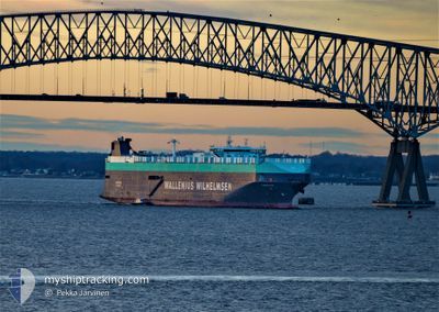
Vehicles Carrier
Current Trip
JP HIC
| Time Travelled | 8 h, 59 mins |
|---|---|
| Remaining Time | --- |
| Distance Travelled | 66.19 nm |
| Remaining Distance | --- |
| AVG Speed | 13.8 Knopen |
| MAX Speed | 17 Knopen |
| AVG Wind | 18.6 knots |
| MAX Wind | 23.4 knots |
| MIN Temp | 17.1°C / 62.78°F |
| MAX Temp | 17.8°C / 64.04°F |
| Diepgang | 10.4 M |
| Positie ontvangen | 2 d geleden |
Current Position
| Lengtegraad | 141.01181° |
|---|---|
| Breedtegraat | 35.81014° |
| Status | Under way using engine |
| Snelheid | 6.8 Knopen |
| Koers | 354° |
| Gebied | North Pacific Ocean |
| Station | T-AIS |
| Positie ontvangen | 2 d geleden |
Info
Information
The current position of TAMESIS is in North Pacific Ocean with coordinates 35.81014° / 141.01181° as reported on 2024-05-26 17:11 by AIS to our vessel tracker app. The vessel's current speed is 6.8 Knopen
The vessel TAMESIS (IMO: 9191307, MMSI: 257565000) is a Vehicles Carrier that was built in 2000 ( 24 Jaar oud ). It's sailing under the flag of [NO] Norway.
In this page you can find informations about the vessels current position, last detected port calls, and current voyage information. If the vessels is not in coverage by AIS you will find the latest position.
The current position of TAMESIS is detected by our AIS receivers and we are not responsible for the reliability of the data. The last position was recorded while the vessel was in Coverage by the Ais receivers of our vessel tracking app.
The current draught of TAMESIS as reported by AIS is 10.4 meters
Weather
| Temperature | 18.8°C / 65.84°F |
|---|---|
| Wind Speed | 14 knots |
| Direction | 351° N |
| Pressure | 1009.3 hPa |
| Humidity | 73.6 % |
| Cloud Coverage | 100 % |
Featured Company
Last Port Calls
| Port | Arrival | Departure | Time In Port |
|---|---|---|---|
| 2024-05-27 22:57 | 2024-05-28 20:32 | 21 h | |
| 2024-05-24 00:20 | 2024-05-24 23:47 | 23 h | |
| 2024-05-22 22:32 | 2024-05-23 09:41 | 11 h | |
| 2024-05-20 21:40 | 2024-05-21 09:26 | 11 h | |
| 2024-05-18 21:08 | 2024-05-19 10:42 | 13 h | |
| 2024-04-03 04:40 | 2024-04-03 17:40 | 13 h | |
| 2024-03-28 09:13 | 2024-03-31 17:02 | 3 d | |
| 2024-03-24 06:45 | 2024-03-25 13:48 | 1 d | |
| 2024-03-19 02:19 | 2024-03-19 21:10 | 18 h | |
| 2024-03-19 01:57 |
Most Visited Ports (Last year)
| Port | Arrivals | |
|---|---|---|
| 5 | ||
| 4 | ||
| 4 | ||
| 4 | ||
| 3 | ||
| 3 |
Last Trips
| Origin | Departure | Destination | Arrival | Distance | |
|---|---|---|---|---|---|
| 2024-05-25 08:47 | 2024-05-28 07:57 | 368.34 nm | |||
| 2024-05-23 18:41 | 2024-05-24 09:20 | 205.77 nm | |||
| 2024-05-21 18:26 | 2024-05-23 07:32 | 367.06 nm | |||
| 2024-05-19 19:42 | 2024-05-21 06:40 | 492.46 nm | |||
| 2024-04-03 13:40 | 2024-05-19 06:08 | 15865.89 nm | |||
| 2024-03-31 13:02 | 2024-04-03 00:40 | 507.99 nm | |||
| 2024-03-25 09:48 | 2024-03-28 05:13 | 557.93 nm | |||
| 2024-03-19 16:10 | 2024-03-24 02:45 | 1554.03 nm | |||
| 2024-02-26 05:23 | 2024-03-18 21:19 | 8428.45 nm | |||
| 2024-02-26 05:23 | 2024-03-18 20:57 | 8428.39 nm |
Events
| Tijd | Evenement | Details | Positie / Bestemming | Info |
|---|---|---|---|---|
| 2024-05-28 20:32 | Vertrekhaven |
|
36.39494 / 140.63646
JP HIC
|
Snelheid: 8.8 kn Koers: 160° |
| 2024-05-28 20:18 | Start beweging |
36.42590 / 140.63194
[JP] HITACHINAKA
|
Snelheid: 4.2 kn Koers: 177° |
|
| 2024-05-27 23:33 | Stop beweging |
36.43063 / 140.62462
[JP] HITACHINAKA
|
Snelheid: 0.2 kn Koers: 273° |
|
| 2024-05-27 22:57 | Aankomsthaven |
|
36.40331 / 140.63245
[JP] HITACHINAKA
|
Snelheid: 11.6 kn Koers: 335° |
| 2024-05-27 21:08 | Start beweging | 16.09 nm, East of NAKAMINATO |
36.25718 / 140.91585
JP HIC
|
Snelheid: 4.1 kn Koers: 353° |
| 2024-05-27 19:57 | Stop beweging | 16.12 nm, East of NAKAMINATO |
36.23950 / 140.90869
JP HIC
|
Snelheid: 0.3 kn Koers: 129° |
| 2024-05-27 16:41 | Start beweging | 18.93 nm, East of NAKAMINATO |
36.22290 / 140.96295
JP HIC
|
Snelheid: 3.2 kn Koers: 18° |
| 2024-05-27 14:53 | Stop beweging | 18.07 nm, South East of NAKAMINATO |
36.21955 / 140.94208
JP HIC
|
Snelheid: 0.1 kn Koers: 155° |
| 2024-05-26 17:17 | Status Changed | Default Under way using engine |
35.82109 / 141.01019
JP HIC
|
Snelheid: 6.8 kn Koers: 354° |
| 2024-05-26 17:11 | Buitenbereik |
35.81014 / 141.01181
North Pacific Ocean
JP HIC
|
Snelheid: 6.8 kn Koers: 354° |