
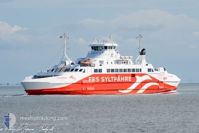
SYLT EXPRESS
Ro-Ro/Passenger Ship
Current Trip
HAVNEBY-LIST-HAVNEBY
| Time Travelled | 1 h, 7 mins |
|---|---|
| Remaining Time | --- |
| Distance Travelled | 6.48 nm |
| Remaining Distance | --- |
| AVG Speed | 11.4 Knopen |
| MAX Speed | 13.5 Knopen |
| AVG Wind | 7 knots |
| MAX Wind | 7 knots |
| MIN Temp | 6.7°C / 44.06°F |
| MAX Temp | 6.8°C / 44.24°F |
| Diepgang | 3.5 M |
| Positie ontvangen | 1 m geleden |
Current Position
| Lengtegraad | --- |
|---|---|
| Breedtegraat | --- |
| Status | Under way using engine |
| Snelheid | |
| Koers | 252° |
| Gebied | North Sea |
| Station | T-AIS |
| Positie ontvangen | 1 m geleden |
Info
Information
The current position of SYLT EXPRESS is in North Sea with coordinates 55.08633° / 8.57081° as reported on 2025-12-20 15:39 by AIS to our vessel tracker app. The vessel's current speed is 0 Knopen
The vessel SYLT EXPRESS (IMO: 9321823, MMSI: 209392000) is a Ro-Ro/Passenger Ship that was built in 2005 ( 20 Jaar oud ). It's sailing under the flag of [CY] Cyprus.
In this page you can find informations about the vessels current position, last detected port calls, and current voyage information. If the vessels is not in coverage by AIS you will find the latest position.
The current position of SYLT EXPRESS is detected by our AIS receivers and we are not responsible for the reliability of the data. The last position was recorded while the vessel was in Coverage by the Ais receivers of our vessel tracking app.
The current draught of SYLT EXPRESS as reported by AIS is 3.5 meters
Weather
| Temperature | 6.7°C / 44.06°F |
|---|---|
| Wind Speed | 7 knots |
| Direction | 208° SSW |
| Pressure | 1017.3 hPa |
| Humidity | 95.1 % |
| Cloud Coverage | 100 % |
Featured Company
Last Port Calls
| Port | Arrival | Departure | Time In Port |
|---|---|---|---|
| 2025-12-20 15:09 | 2025-12-20 15:33 | 24 m | |
| 2025-12-20 13:11 | 2025-12-20 13:37 | 25 m | |
| 2025-12-20 11:12 | 2025-12-20 11:37 | 24 m | |
| 2025-12-20 09:07 | 2025-12-20 09:36 | 28 m | |
| 2025-12-19 18:12 | 2025-12-19 18:28 | 15 m | |
| 2025-12-19 15:06 | 2025-12-19 15:33 | 27 m | |
| 2025-12-19 13:19 | 2025-12-19 13:39 | 19 m | |
| 2025-12-19 11:13 | 2025-12-19 11:37 | 23 m | |
| 2025-12-19 09:10 | 2025-12-19 09:35 | 25 m | |
| 2025-12-19 07:25 | 2025-12-19 07:37 | 12 m |
Last Trips
| Origin | Departure | Destination | Arrival | Distance | |
|---|---|---|---|---|---|
| 2025-12-20 13:37 | 2025-12-20 15:09 | 12.35 nm | |||
| 2025-12-20 11:37 | 2025-12-20 13:11 | 13.71 nm | |||
| 2025-12-20 09:36 | 2025-12-20 11:12 | 13.60 nm | |||
| 2025-12-19 18:28 | 2025-12-20 09:07 | 13.71 nm | |||
| 2025-12-19 15:33 | 2025-12-19 18:12 | 13.93 nm | |||
| 2025-12-19 13:39 | 2025-12-19 15:06 | 13.26 nm | |||
| 2025-12-19 11:37 | 2025-12-19 13:19 | 13.60 nm | |||
| 2025-12-19 09:35 | 2025-12-19 11:13 | 13.94 nm | |||
| 2025-12-19 07:37 | 2025-12-19 09:10 | 13.86 nm | |||
| 2025-12-19 06:04 | 2025-12-19 07:25 | 13.81 nm |
Events
| Tijd | Evenement | Details | Positie / Bestemming | Info |
|---|---|---|---|---|
| 2025-12-20 15:05 | Stop beweging | 6.17 nm, North East of LIST SYLT |
55.08632 / 8.57080
HAVNEBY-LIST-HAVNEBY
|
Snelheid: 0.1 kn Koers: 253° |
| 2025-12-20 14:43 | Wijzig zee gebeid | Danish part of the North Sea German part of the North Sea |
55.05152 / 8.48065
North Sea
HAVNEBY-LIST-HAVNEBY
|
Snelheid: 14.3 kn Koers: 57.6° |
| 2025-12-20 14:33 | Vertrekhaven |
|
55.01788 / 8.44852
HAVNEBY-LIST-HAVNEBY
|
Snelheid: 13.6 kn Koers: 30° |
| 2025-12-20 14:31 | Start beweging |
55.01353 / 8.44114
[DE] LIST SYLT
|
Snelheid: 6.5 kn Koers: 97° |
|
| 2025-12-20 14:14 | Stop beweging |
55.01514 / 8.43971
[DE] LIST SYLT
|
Snelheid: 0.3 kn Koers: 0° |
|
| 2025-12-20 14:09 | Aankomsthaven |
|
55.01541 / 8.44605
[DE] LIST SYLT
|
Snelheid: 10.6 kn Koers: 206.8° |
| 2025-12-20 13:55 | Wijzig zee gebeid | German part of the North Sea Danish part of the North Sea |
55.05023 / 8.47927
North Sea
HAVNEBY-LIST-HAVNEBY
|
Snelheid: 11.4 kn Koers: 243.5° |
| 2025-12-20 13:31 | Start beweging | 6.26 nm, North East of LIST SYLT |
55.08640 / 8.57400
HAVNEBY-LIST-HAVNEBY
|
Snelheid: 7.2 kn Koers: 103.6° |
| 2025-12-20 13:14 | Stop beweging | 6.18 nm, North East of LIST SYLT |
55.08633 / 8.57083
HAVNEBY-LIST-HAVNEBY
|
Snelheid: 0.2 kn Koers: 254° |
| 2025-12-20 12:51 | Wijzig zee gebeid | Danish part of the North Sea German part of the North Sea |
55.05380 / 8.48921
North Sea
HAVNEBY-LIST-HAVNEBY
|
Snelheid: 12.2 kn Koers: 78.2° |