
SCHELDT RIVER
Dredging or underwater ops
Current Trip
DREDGING SCHELDE
| Time Travelled | 2 days |
|---|---|
| Remaining Time | --- |
| Distance Travelled | 493.61 nm |
| Remaining Distance | --- |
| AVG Speed | 9.9 Knopen |
| MAX Speed | 16.8 Knopen |
| AVG Wind | 15.7 knots |
| MAX Wind | 31 knots |
| MIN Temp | 5.2°C / 41.36°F |
| MAX Temp | 14.4°C / 57.92°F |
| Diepgang | 5.2 M |
| Positie ontvangen | 1 m geleden |
Current Position
| Lengtegraad | --- |
|---|---|
| Breedtegraat | --- |
| Status | Restricted manoeuverability |
| Snelheid | 12.3 Knopen |
| Koers | 110.5° |
| Gebied | North Sea |
| Station | T-AIS |
| Positie ontvangen | 1 m geleden |
Info
Information
The current position of SCHELDT RIVER is in North Sea with coordinates 51.43818° / 3.66800° as reported on 2025-12-08 17:20 by AIS to our vessel tracker app. The vessel's current speed is 12.3 Knopen
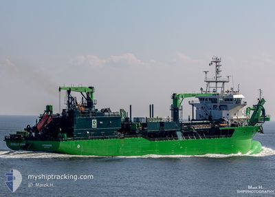
The vessel SCHELDT RIVER (IMO: 9778143, MMSI: 205708000) is a Dredging or underwater ops It's sailing under the flag of [BE] Belgium.
In this page you can find informations about the vessels current position, last detected port calls, and current voyage information. If the vessels is not in coverage by AIS you will find the latest position.
The current position of SCHELDT RIVER is detected by our AIS receivers and we are not responsible for the reliability of the data. The last position was recorded while the vessel was in Coverage by the Ais receivers of our vessel tracking app.
The current draught of SCHELDT RIVER as reported by AIS is 5.2 meters
Weather
| Temperature | 13.3°C / 55.94°F |
|---|---|
| Wind Speed | 12 knots |
| Direction | 230° SW |
| Pressure | 1012.3 hPa |
| Humidity | 87 % |
| Cloud Coverage | 100 % |
Featured Company
Last Port Calls
| Port | Arrival | Departure | Time In Port |
|---|---|---|---|
| 2025-12-05 05:48 | 2025-12-05 20:40 | 14 h | |
| 2025-12-04 20:57 | 2025-12-04 21:15 | 18 m | |
| 2025-12-04 14:19 | 2025-12-04 14:44 | 24 m | |
| 2025-12-04 07:34 | 2025-12-04 08:08 | 34 m | |
| 2025-12-04 01:18 | 2025-12-04 01:40 | 21 m | |
| 2025-12-03 19:00 | 2025-12-03 19:26 | 26 m | |
| 2025-12-03 12:51 | 2025-12-03 13:10 | 18 m | |
| 2025-12-03 06:44 | 2025-12-03 07:09 | 25 m | |
| 2025-12-02 20:24 | 2025-12-02 20:51 | 26 m | |
| 2025-12-02 13:47 | 2025-12-02 14:17 | 29 m |
Most Visited Ports (Last year)
| Port | Arrivals | |
|---|---|---|
| 43 | ||
| 11 | ||
| 1 |
Last Trips
| Origin | Departure | Destination | Arrival | Distance | |
|---|---|---|---|---|---|
| 2025-12-04 21:15 | 2025-12-05 05:48 | 54.07 nm | |||
| 2025-12-04 14:44 | 2025-12-04 20:57 | 26.05 nm | |||
| 2025-12-04 08:08 | 2025-12-04 14:19 | 28.00 nm | |||
| 2025-12-04 01:40 | 2025-12-04 07:34 | 22.67 nm | |||
| 2025-12-03 19:26 | 2025-12-04 01:18 | 28.88 nm | |||
| 2025-12-03 13:10 | 2025-12-03 19:00 | 23.92 nm | |||
| 2025-12-03 07:09 | 2025-12-03 12:51 | 26.19 nm | |||
| 2025-12-02 20:51 | 2025-12-03 06:44 | 44.63 nm | |||
| 2025-12-02 14:17 | 2025-12-02 20:24 | 26.44 nm | |||
| 2025-12-02 07:37 | 2025-12-02 13:47 | 24.07 nm |
Events
| Tijd | Evenement | Details | Positie / Bestemming | Info |
|---|---|---|---|---|
| 2025-12-08 17:09 | Start beweging | 2.15 nm, South East of VLISSINGEN STATION |
51.42040 / 3.62798
DREDGING SCHELDE
|
Snelheid: 5.9 kn Koers: 336° |
| 2025-12-08 16:57 | Stop beweging | 2.26 nm, South East of VLISSINGEN STATION |
51.41902 / 3.63012
DREDGING SCHELDE
|
Snelheid: 0.3 kn Koers: 139° |
| 2025-12-08 16:20 | Start beweging | 1.47 nm, South of ZEELAND REFINERY |
51.38927 / 3.71635
DREDGING SCHELDE
|
Snelheid: 3.2 kn Koers: 337° |
| 2025-12-08 16:03 | Stop beweging | 1.85 nm, South of ZEELAND REFINERY |
51.38200 / 3.72316
DREDGING SCHELDE
|
Snelheid: 0.3 kn Koers: 1° |
| 2025-12-08 15:37 | Start beweging | 1.81 nm, South East of VLISSINGEN STATION |
51.42247 / 3.61738
DREDGING SCHELDE
|
Snelheid: 3.6 kn Koers: 127° |
| 2025-12-08 15:31 | Stop beweging | 1.77 nm, South East of VLISSINGEN STATION |
51.42211 / 3.61448
DREDGING SCHELDE
|
Snelheid: 0.3 kn Koers: 256° |
| 2025-12-08 14:58 | Start beweging | 1.26 nm, South West of ZEELAND REFINERY |
51.39378 / 3.71351
DREDGING SCHELDE
|
Snelheid: 5.2 kn Koers: 344.8° |
| 2025-12-08 14:51 | Stop beweging | 1.34 nm, South of ZEELAND REFINERY |
51.39202 / 3.71463
DREDGING SCHELDE
|
Snelheid: 0.3 kn Koers: 334° |
| 2025-12-08 14:02 | Start beweging | 2.05 nm, South East of VLISSINGEN STATION |
51.42054 / 3.62405
DREDGING SCHELDE
|
Snelheid: 7.9 kn Koers: 45.4° |
| 2025-12-08 13:53 | Stop beweging | 2.12 nm, South East of VLISSINGEN STATION |
51.41869 / 3.62330
DREDGING SCHELDE
|
Snelheid: 0.2 kn Koers: 272° |