
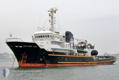
SALVAGE ACE
Tug
Current Trip
TW KHH
| Time Travelled | 15 days |
|---|---|
| Remaining Time | --- |
| Distance Travelled | 24.56 nm |
| Remaining Distance | --- |
| AVG Speed | 8.3 Knopen |
| MAX Speed | 9.9 Knopen |
| AVG Wind | 7.2 knots |
| MAX Wind | 16.6 knots |
| MIN Temp | 22°C / 71.6°F |
| MAX Temp | 30.4°C / 86.72°F |
| Diepgang | 6 M |
| Positie ontvangen | 5 m geleden |
Current Position
| Lengtegraad | 120.23839° |
|---|---|
| Breedtegraat | 22.64761° |
| Status | At anchor |
| Snelheid | 0.1 Knopen |
| Koers | 188° |
| Gebied | South China Sea |
| Station | T-AIS |
| Positie ontvangen | 5 m geleden |
Info
Information
The current position of SALVAGE ACE is in South China Sea with coordinates 22.64761° / 120.23839° as reported on 2024-04-27 09:01 by AIS to our vessel tracker app. The vessel's current speed is 0.1 Knopen
The vessel SALVAGE ACE (IMO: 7626841, MMSI: 376513000) is a Tug that was built in 1976 ( 48 Jaar oud ). It's sailing under the flag of [VC] St Vincent Grenadines.
In this page you can find informations about the vessels current position, last detected port calls, and current voyage information. If the vessels is not in coverage by AIS you will find the latest position.
The current position of SALVAGE ACE is detected by our AIS receivers and we are not responsible for the reliability of the data. The last position was recorded while the vessel was in Coverage by the Ais receivers of our vessel tracking app.
The current draught of SALVAGE ACE as reported by AIS is 6 meters
Weather
| Temperature | 26.9°C / 80.42°F |
|---|---|
| Wind Speed | 7 knots |
| Direction | 170° S |
| Pressure | 1009 hPa |
| Humidity | 70.7 % |
| Cloud Coverage | 34 % |
Featured Company
Events
| Tijd | Evenement | Details | Positie / Bestemming | Info |
|---|---|---|---|---|
| 2024-04-27 09:01 | Status Changed | At anchor Default |
22.64761 / 120.23839
TW KHH
|
Snelheid: Koers: 177° |
| 2024-04-27 08:49 | Status Changed | Default At anchor |
22.64761 / 120.23839
TW KHH
|
Snelheid: 0.1 kn Koers: 170° |
| 2024-04-27 07:43 | Status Changed | At anchor Default |
22.64762 / 120.23852
TW KHH
|
Snelheid: 0.1 kn Koers: 180° |
| 2024-04-27 07:31 | Status Changed | Default At anchor |
22.64761 / 120.23850
TW KHH
|
Snelheid: 0.1 kn Koers: 180° |
| 2024-04-27 06:25 | Status Changed | At anchor Default |
22.64758 / 120.23837
TW KHH
|
Snelheid: 0.7 kn Koers: 179° |
| 2024-04-27 06:16 | Status Changed | Default At anchor |
22.64751 / 120.23825
TW KHH
|
Snelheid: 0.6 kn Koers: 202° |
| 2024-04-27 05:25 | Status Changed | At anchor Default |
22.64761 / 120.23845
TW KHH
|
Snelheid: 0.2 kn Koers: 174° |
| 2024-04-27 05:19 | Status Changed | Default At anchor |
22.64748 / 120.23823
TW KHH
|
Snelheid: 0.5 kn Koers: 188° |
| 2024-04-27 02:01 | Status Changed | At anchor Default |
22.64752 / 120.23858
TW KHH
|
Snelheid: 0.2 kn Koers: 206° |
| 2024-04-27 01:49 | Status Changed | Default At anchor |
22.64753 / 120.23856
TW KHH
|
Snelheid: 0.1 kn Koers: 207° |